Rapid GIS Deployment: New Mexico Gas Company Starts from Scratch
By Jessica Wyland, Esri Writer
When New Mexico public utilities company PNM sold its gas assets this year to Continental Energy Systems, the newly formed New Mexico Gas Company faced a significant hurdle: maintain existing service levels for its 500,000 customers while building an operations and engineering platform from scratch.
 Task assistant tools have empowered New Mexico Gas Company designers with the ability to map designs for new construction and maintenance. |
The utility needed its distribution information-related to pipes, valves, meters, work orders, and customers-in one place where it could be stored, managed, and accessed by everyone on staff. A legacy geographic information system (GIS) and various computer-aided drafting (CAD) and paper mapping systems had to be converted to one GIS. The company also needed a core technology solution to facilitate engineering work and field access to data.
New Mexico Gas Company selected Esri's ArcGIS Desktop technology as its GIS platform, giving the utility the ability to use, share, and edit data for operations, maintenance, and engineering functions. Within three months, the utility had consolidated asset, customer, and historical data into one place and deployed GIS tools throughout the company. The GIS launch was speedy, budget constraints were met, and employees were trained in time to use the new technology.
"With GIS-based maps, we can see our entire state at once," said Curtis Winner, New Mexico Gas Company manager of land services. "I turn on the aerial imagery, and all of a sudden, I can see what is going on in Carlsbad, a five-hour drive from our Albuquerque office. It really helps staff evaluate projects and saves on travel. Using GIS tools such as bookmarks, we can jump all over the state without leaving the office."
The first step in implementing New Mexico Gas Company's GIS platform was to migrate existing applications to the GIS. The second step was to focus on the data stored in AMIGO, the utility's homegrown database for gas distribution. Information-such as construction orders, asset data, and leak and repair reports-was pulled into the GIS by linking each piece to relevant points, lines, and polygons.
"We looked at what we had, and we knew we could tie in the AMIGO data with attributes in GIS to improve data accuracy in the database," Winner said.
To enhance the geodatabase, New Mexico Gas Company brought in aerial photography and county street, parcel, and environmental data. The utility built specific applications for both mapping and design of distribution pipelines and other assets.
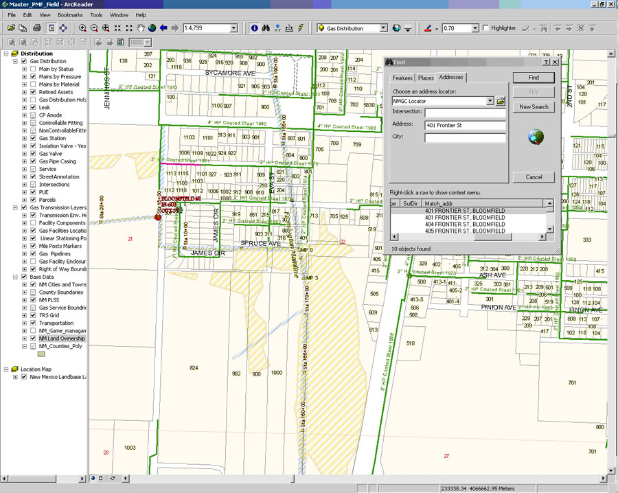 By building a combined address locator of street data and parcels, New Mexico Gas Company is able to quickly locate areas of interest. |
With GIS-based utility maps, the operations staff is able to view county assessor and parcel data, along with topography, aerial images, and customer information, and see how that data relates to the company's transmission lines.
Field crews use Global Positioning System (GPS) data to locate facilities and update asset information. Because all the data is geospatially enabled, the utility can quickly create work orders for new construction and maintenance. Using GIS-based spatial analysis, the company performs least-cost analysis to site potential pipeline corridors. These routes also can be imported into the utility's hydraulic modeling software, ensuring accurate and timely model runs.
"Potential routes can be identified quickly, and we know the exact pipe length for generating accurate cost estimates," Winner said. "We have taken a lot of the what-ifs out of the equation and can quantify our recommendations."
New Mexico Gas Company also uses GIS for environmental planning and permitting. The staff can view assets relative to groundwater discharge zones and other environmentally sensitive areas such as cultural sites and threatened and endangered species habitats.
"The GIS is running smoothly and being used company-wide. Without the support of Esri's staff to guide us through the process, this would not have been possible," said Deborah McDonald, GIS administrator, New Mexico Gas Company.
For more information about the utility's GIS project, contact Curtis Winner at Curtis.winner@nmgc.com.