ArcWatch: GIS News, Views, and Insights
November 2010
Web GIS: Principles and Applications
By Carolyn G. Schatz, Esri Press Editor
Web GIS: Principles and Applications is now available.
When Pinde Fu, senior developer and project lead at Esri Professional Services, talks about Web GIS, his eyes light up. "Web GIS is very exciting, it's fascinating—I like it," he says as if talking about a favorite electronic gadget. "I want other people to know this field."
His passion for the technology and love of the science shines through in Web GIS: Principles and Applications from Esri Press. The book, by Fu and Jiulin Sun—now available for purchase—explores the principles and concepts of one of the fastest growing fields in information technology: the use of GIS on the Web.
"The Web is the ideal platform for GIS," Fu says. Because they complement each other so well, the Web and GIS are a natural fit. Web GIS allows professionals, organizations, and the public to share and collaborate, making GIS eminently more accessible to a wide range of users—and at a much lower cost.
"Before Web GIS, data was very expensive," Fu says. Hardware, software, and data all had to be available on the same local area network, which meant it had to be locally owned. Putting GIS on the Web changes all that, allowing data to be shared in many ways.

Pinde Fu from Esri co-authored Web GIS.
"Nowadays, you can discover lots of resources from the Web or the cloud—data, maps, models," says Fu, speaking of cloud computing, one of the many new concepts that are detailed in the book. Fu, a specialist in software engineering and architectural design, effortlessly dots his conversation with new concepts and new technologies, sprinkling in the words "fun" and "easy to use" as he goes.
"Today is very different from before the Web," Fu says. "With Web GIS today, you can discover and search online and remix what's there or mash it up to build applications. In case it's not available online, you can mix your own content with that of others to create new value applications." The ability to share resources and mash them up to create ever more useful applications is of enormous benefit to government, business, and individuals—an important theme of the book.
It is that sense of boundless potential that excites Fu, who is enthusiastic about the societal implications of using GIS to solve world problems. "I like to work with people and see how GIS is applied in the real world to make real solutions," he says. It is why Fu enjoys working on the applications development services team in the Professional Services division at Esri—so he can work directly with customers and see how his applications can work for them. "GIS has tremendous value, but this was locked up to a limited number of professionals," Fu says. "The Web really unlocked GIS and made it available to everyone."
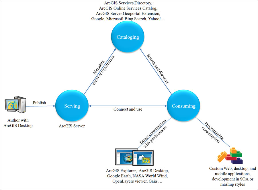
Web services are the core of Web GIS. Web GIS products have evolved to support geospatial Web services in authoring, publishing, cataloging, and using services.
Fu hopes his new book will do the same for readers—unlocking the door to a wide new world. Fu and Sun's book emphasizes the theories and concepts of the technology as well as the evolution and principles of Web GIS, yet Web GIS also manages to include plenty of practical applications, too.
Fu realized the need for such a book when Sun invited him to give a seminar on Web GIS three years ago at the Institute of Geographic Sciences and Natural Resources at the Chinese Academy of Sciences, where Sun is chief scientist. "Other than some product and programming tutorials, I discovered there was not much conceptual-level content out there, so I started looking at the big picture of Web GIS," Fu says.
"There are many software manuals and tutorials on how to do specific tasks. That doesn't give you the big picture. It lets you see the trees but not the whole forest—how Web GIS applies to real-world situations. Practice without theory is blind."
The book, based on a course Fu is teaching with Esri China (Beijing) Limited at Henan University in Kaifeng, China, is primarily designed as a university textbook, although it is chock-full of nuggets of solid information to appeal to a diverse audience.
"Web GIS provides concepts, methodology, principles—good not only for students but for a big audience," Fu says. "Researchers, government employees, and businesses can all use the book to see how Web GIS can help them in their work."
While the book is largely aimed at how Web GIS is used by government agencies and business entities, it also provides a touchstone for developers and individuals seeking general knowledge of Web GIS.
"It explains why there is this technology: How did it emerge and evolve? Where is it going? What are the impacts on GIS and users? What are the challenges and new research areas?" Fu says.
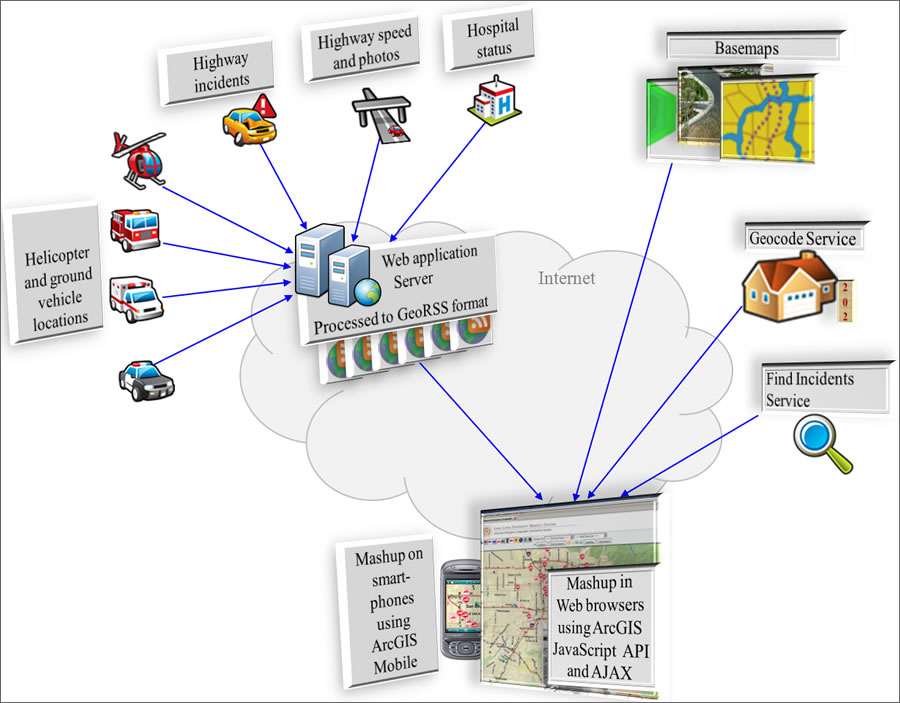
A geospatial mashup dynamically integrates disparate Web resources to create a new application with added value.
In the book, Fu delves into many hot topics—geospatial Web services, REST Web services, cloud computing, geoportals, mashups, mobile GIS, Gov 2.0, business intelligence, virtual reality, volunteered geographic information (VGI), geotagging, geotargeting, the sensor Web, Semantic Web, and many more. While he's at it, he deftly takes the mystery out of some of the new terminology, such as computing in the cloud.
"With the cloud, the computing tasks traditionally handled by individual computers locally will instead be tackled by large computer centers connected over the Internet and available as Web-based services," Fu explains. "Someone is doing this for you. You really don't know where it's coming from, but you don't have to worry about it." While this may be true for the average user, Fu points out that challenges remain in terms of ensuring data security and privacy as well as establishing standards among multiple clouds.
The complexity of such issues hasn't deterred the public's interest in GIS, however, as more people start to routinely collect geographic information and join in the VGI parade.
"VGI is so hot," Fu says. Indeed, the growing popularity of VGI, where Web users contribute geospatial information, is a theme of the book. The proliferation of consumer GPS devices, cell phones, cameras, and iPods has turned the public into "6 billion walking sensors," says Fu, who seems to relish the thought of enormous volumes of geospatial data now at developers' fingertips. "It is the food of GIS," he says.
VGI embodies the spirit of the Web, and the increased public participation in GIS lends itself to geocollaboration and sharing data. "Web GIS has become an extension of democracy," Fu says.
Geocollaboration is a big part of the Web GIS environment, and mashups facilitate the expansion of data sharing. "Mashups have been around for years, since Web services emerged in the late 1990s, but the browser-side mapping APIs, which emerged in 2005, have made mashups much easier," Fu says. "They are the main form of Web GIS now."
Mashups are used by a variety of organizations to take advantage of multiple resources, from Web services to data feeds. With Web GIS, agencies can take all the data from different organizations and "remix it, mash it up, analyze it, produce something new and invaluable, and share it across organizations, with those in the office and those out in the field. That's becoming common now," Fu says.
In his work as technical lead for the Advanced Emergency GIS project at Loma Linda University Medical Center in Loma Linda, California, and developing applications for emergency response, Fu has seen the value of Web GIS up close. Emergency operations centers need a variety of data that is comprehensive and accurate, and they need it fast.
So, how do authorities get all the basemaps, feeds, and geoprocessing services they need? From using the Web, of course.
"Without Web GIS, what else has the far reach of the Web, the power of spatially based information integration, the intelligence of geographic analysis, the intuitive visualization, and the real-time dissemination capabilities?" he asks matter-of-factly.

A variety of bottlenecks can challenge the quality of a Web GIS application.
Web GIS is a fast-changing field—indeed, the technology has gone through many iterations since Fu joined Esri China in 1994 and during his employment at Esri in Redlands, California, since 2000. It is a primary reason why Fu chose to go with a concept book over a step-by-step "button" approach or line-by-line programming guide.
"I found that if you tie the book to too many technical details, it'll be quickly outdated and in need of extensive updates," Fu says. "We do talk about technology in the book—from server side to client side, especially browser side, and from individual products to system architectures and design principles—but such contents are kept at the concept and philosophy level, which can support users for a longer time. The concept approach gives you a firm foundation to do a variety of tasks. Rather than click that certain button, it lets you see the whole forest, not just a leaf on the tree."
GIS is, after all, largely an application-driven technology. "We talk about many real-world examples of real applications in e-government and e-business, from individual projects to national and global spatial data infrastructure," Fu says. "This book tries to provide the big picture—the whole forest."
Fu and Sun hope that by unraveling the mystique of Web GIS in their new book, they will lure students to explore the technology's vast potential.
"This book uses an encouraging tone for two reasons," Fu says. "I really believe it, and to motivate readers—developers, managers, and especially students—to take the Web GIS opportunity. I want to let students use geospatial science to do something really useful and interesting."
And that is the big draw of Web GIS, Fu says. It is just sitting there, waiting to be used. "Web GIS is becoming ubiquitous—it is available on our desktops, laptops, cell phones, GPS navigators, and other mobile devices anywhere, anytime. It can eventually deliver the truly societal GIS, which is very exciting."