ArcWatch: GIS News, Views, and Insights
November 2012
Bug Wars
The Battle against Mosquito-Borne Illnesses Starts with Technicians Armed with GIS
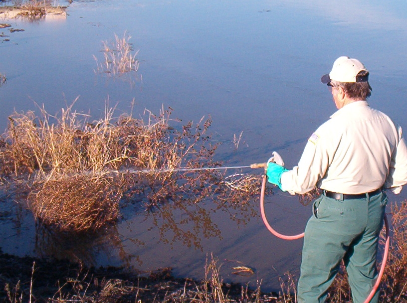
San Joaquin County mosquito control technician Richard Capuccini sprays insecticide into a dairy pond that contains mosquito larvae, a process called larviciding.
With the motto "Map, Track, and Attack," a suite of Esri-based software applications called Sentinel GIS is helping the San Joaquin County Mosquito and Vector Control District in California's Central Valley better manage mosquito control treatment, surveillance, and work orders.
Sentinel GIS, developed by Jerome, Idaho-based Electronic Data Solutions (Elecdata), is mainly a mobile solution that field technicians use to collect information about mosquitoes, keep track of how much and where chemical pesticides are applied, and record and manage requests for service and work orders.
By using Sentinel GIS and GPS coordinates that correspond to property ownership boundaries, mosquito control technicians can also easily identify exactly where to spray the chemicals and what areas are off-limits due to regulations or other restrictions. The software warns the workers about what areas to avoid such as organic farms and beehives. And when they return to the office, they can transfer the mosquito surveillance and treatment data on the mobile device into GIS desktop software.
"We can now download the work of the technician versus having to go through another data entry person back in the office," said Eddie Lucchesi, the district's assistant manager. Lucchesi recalls the days before GIS when mosquito control field technicians and their supervisors worked mostly with pencil and paper, hard-copy map books, and spreadsheets to keep track of where and how much chemical pesticide was dispersed in different areas. They did this to comply with operational and regulatory requirements.
"Of course it was all transcribed into a computer program, which meant job security for some, but it was much more laborious," Lucchesi said.
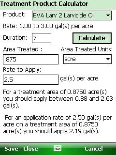
When a larval treatment is necessary, the Sentinel GIS mobile software's built-in calculator helps the field technician apply the proper amount of product according to EPA regulations.
More Precise Alternative Overdue
About five years ago, the district joined many other abatement agencies nationwide that began to use Sentinel GIS, an innovative, time-saving, and more precise technology that Elecdata developed using Esri ArcGIS and ArcPad software. The company, a distributor and system integrator of field data collection instruments, has specialized in mosquito abatement solutions since 2004 and is focused on improving its methods of collecting and recording mosquito control data.
The technology was long overdue. Worldwide, more than 1 million people die and 700 million more are infected each year by some type of disease that mosquitoes carry. In the United States, more than 200 deaths from the mosquito-borne West Nile virus have been reported to the Centers for Disease Control and Prevention so far this year.
To reduce people's chances of becoming ill, vector control agencies operate mosquito control programs that include pesticide spraying to get rid of the larvae, pupae, and adult insects. It's also important to monitor data related to mosquito control, which is why city, state, and federal public health officials are constantly on the lookout for the most effective and efficient solutions for data collection and management.
Sentinel GIS records and manages mosquito control and workflow data using four applications designed for mobile and desktop work that rely, respectively, on ArcPad and ArcGIS 10 for Desktop. The application modules include the following:
Larvicide to collect, record, and manage data related to treating mosquito larvae and pupae with pesticides. Field inspectors can download information about previous inspections, along with maps and GIS layers, into their mobile devices. In the field, they can map the sites being treated and record data about the application of chemicals, along with the efficacy dates. Once in ArcGIS, those dates can be used to schedule follow-up visits.
Adulticide to collect, record, and manage data related to spraying chemical pesticides to control adult mosquitoes. The application records the amount of chemical sprayed and where it's being applied. It also issues "no spray zone" warnings.
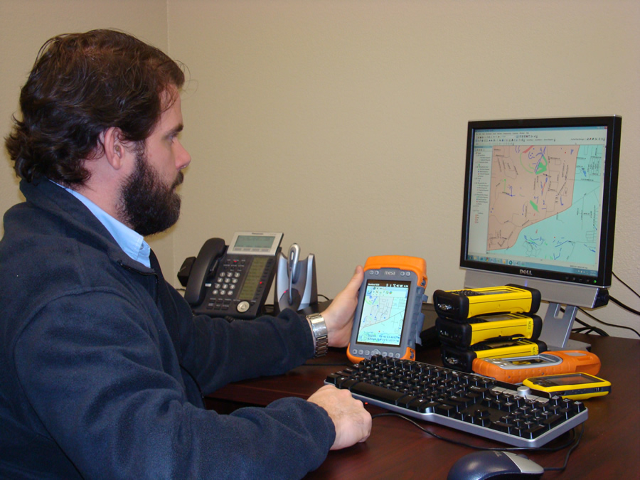
Chad Minteer, mobile GIS software solutions manager for Elecdata, works with the maps in Sentinel GIS.
Surveillance to collect information about mosquito populations. A mosquito disease distribution map layer displayed in the desktop application, which uses Esri ArcGIS for Desktop tools, helps managers prioritize and schedule mosquito control treatments.
Service Request to create, view, and track requests to treat mosquitoes and to map and schedule the requests.
Agencies can add modules as needed. All four applications use a similar process to prepare, collect, and report mosquito control data.
Recording data about where larvae and mosquitoes are found and where spraying occurs is important for several reasons. Besides using the information to comply with regulations from the Environmental Protection Agency (EPA) and other agencies, data collected and managed with Sentinel GIS can be used to better inform the public about what areas have been treated, said Chad Minteer, mobile GIS software solutions manager for Elecdata.
The system also makes the process of requesting service for mosquito problems and scheduling treatment more efficient. And once technicians are back at the office, maps and GIS databases can be immediately updated, reports quickly created, and important analyses performed. The information generated helps meet regulatory requirements.
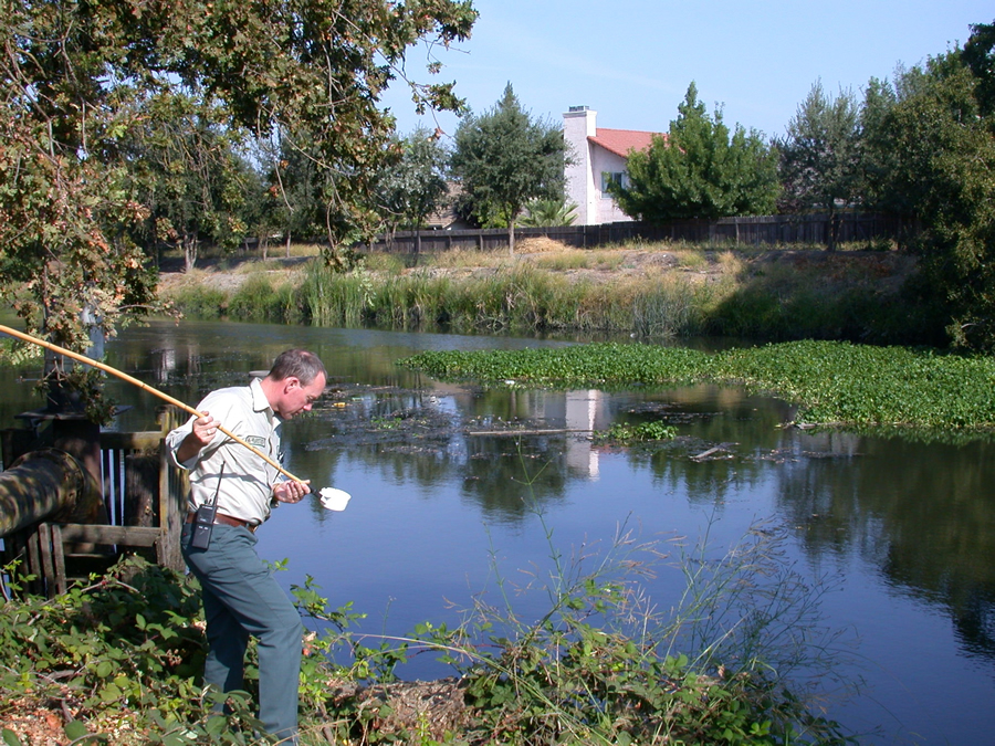
San Joaquin County mosquito control supervisor Brian Heine collects mosquito larvae samples from a lagoon that abuts a subdivision. Obtaining a larval count from water samples is part of conducting surveillance.
Less Paper, More Accuracy Needed
The federal Clean Water Act of 1972, passed to restore and maintain the chemical, physical, and biologic integrity of the nation's waters, spurred development of safer, integrated pest management programs that include information systems such as Sentinel GIS.
Authorized by this law, the National Pollutant Discharge Elimination System (NPDES) permit program called for more stringent reporting to the EPA and other government agencies about where, when, and how much of these chemicals are used on the land.
The Sentinel GIS Adulticide application module, for example, is compatible with a vehicle-mounted fogger that applies the chemicals that kill adult mosquitoes as the vehicle moves through an area. The application displays both the areas that need to be treated and the "no spray" zones and records the GPS positions of where the field technician has applied the chemicals. This helps minimize chemical usage, comply with regulations, and reduce costs.
Using Sentinel GIS saves time by eliminating paperwork and allows fieldwork to be a lot more precise, Lucchesi said. "We previously used [Public Land] Survey township/range and section identifiers as legal property descriptions for [applying] pesticide," he said. "But by using GPS coordinates that correspond to property ownership boundaries, we could identify exactly where that material went." This means that technicians can comply with federal and state reporting regulations and save on chemicals, he said.