IRS Uses GIS to Support Real Estate Decisions
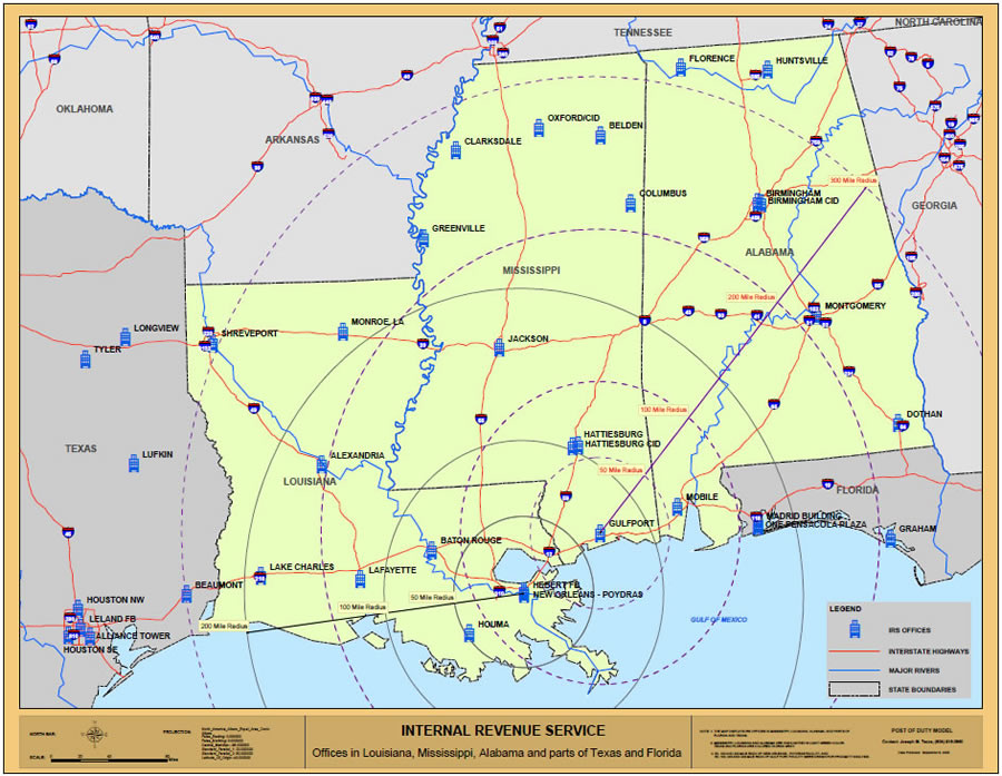 During Hurricane Katrina, several IRS facilities were seriously impacted. The Post of Duty Location Model Application helped the agency identify alternative locations where IRS employees could report. |
Part of the mission of the United States Internal Revenue Service (IRS) is to provide taxpayers with top quality service by helping them understand and meet their tax responsibilities. To support this mission, the IRS has taxpayer assistance centers (TACs) located across the United States so taxpayers can receive face-to-face help with their tax filing process. The IRS real estate portfolio includes more than 700 buildings, most of which are leased, including 14 territory offices.
To better manage its facilities, the IRS developed a GIS-based Post of Duty Location Model (PODLM) application that allows the agency to optimally analyze current office locations and evaluate proposed sites. Realty specialists in each of the territory offices continually monitor area facilities.
When a lease expires, upgrades are being considered for a facility, or a proposal is made to consolidate two facilities, the PODLM is utilized. Prior to this GIS application, the site selection process was decentralized and carried out primarily at the local level with paper maps and pushpins. The PODLM is centralized at the national level of the IRS and automated processes are used to analyze site suitability such as proximity to taxpayer and staff residences. In this way, the IRS can also more easily consider a facility in relations to its overall realty portfolio.
"We wanted a system that allows us to select a variety of study areas, such as ZIP codes within a 30 mile radius, a group of counties, metropolitan statistical areas, or a polygon that includes various IRS offices in the area," says Joseph Tezza, project manager for Post of Duty Location Model, IRS. "We had to have the ability to derive study areas from numerous perspectives, and GIS does that for us."
Convenience for Customers and Staff
As a result of the IRS Restructuring and Reform Act of 1998, the IRS was broken into four major operating divisions that are customer focused based on filer type: Large and mid-sized business, small business/self-employed, wage and investment, and tax exempt and government entities.
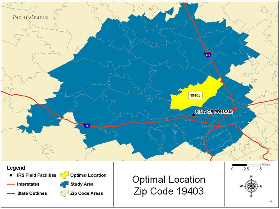 The Post of Duty Location Model analyzes the current IRS field facility and reveals the optimal location (shown here in yellow), which is placed it in the path customers most often use. |
At the national level, the IRS gathers data including filer type from business units and inputs it into Maximal MPL optimization software that's tied to ArcGIS Desktop software.
As the IRS moved toward operational function and addressed specific filers, they decided to use an optimization scenario to minimize distances traveled for particular customers. If the IRS wants to place an office tailored to small business owners, it has the combination of geographic data and filer data to accurately place the new office.
With the optimization software and GIS, the IRS can extract location-based data from tax files, which allows realty specialists to reduce costs involved in taxpayer or IRS employee travel. "By doing this analysis and placing our offices in locations that minimize travel, there are significant savings for both the taxpayers as they go into our offices to pick up forms and meet with our staff as well for the government when employees visit offices for compliance or educational visits," Tezza says.
The IRS can now show the geographic distribution of filers within a certain area. The staff can also visualize data including population projections, crime patterns, public transportation, congressional districts, and tax returns organized by return type. Additionally, the application provides a consistent process for justifying facility placement supported by extensive data collection and analysis over time.
During Hurricane Katrina, the IRS was able to perform buffer analysis showing where employees' residences and IRS offices were in the impacted areas. The application also showed offices that were still able to serve the public. This also helped impacted employees get back to work quickly in another office if their office was damaged.
Automating processes related to site selection ultimately save staff significant time and effort. "It usually only takes two to three hours to put together information that used to take weeks or even months for the local offices to put together," Tezza says.
For more information, contact, Joseph Tezza, project manager of post of duty model, IRS, at Joseph.Tezza@irs.gov.