Electric Company Easily Designs GIS Web Applications Using ArcGIS Server
By Barbara Shields, Esri Writer
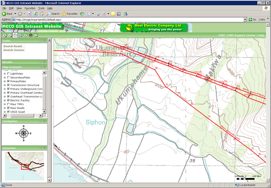 Asset map helps MECO's field personnel locate facilities within a transmission corridor. |
When Maui Electric Company, Limited (MECO), realized its old mapping methods lacked the functionality the utility needed, the search was on for a better system. The company's Information Services supervisors decided to revitalize MECO's mapping effort with Esri's ArcGIS software, and now server-based GIS technology delivers applications for many people to use throughout the company.
MECO's GIS assessment criteria included (1) functionality, (2) scalability, and (3) ease of use. Projects needed to be managed by the company's one-person GIS shop, which had to be able to create quality deliverables straight out of the box. For these reasons, MECO selected ArcGIS software.
Initially, product outputs included quality hard-copy maps showing MECO's transmission and distribution (T&D) systems and their relation to the surrounding geography. The application also needed to consolidate various available data sources. In 2006, the one-man GIS shop began using ArcGIS 9.1 to combine various types of data such as GPS-collected pole locations, county parcel information, county road information, CAD drawings, and aerial raster imagery. "The ArcGIS Desktop platform gave me the ability to take disparate pieces of spatial data and link and relate them geographically," said Eric Abe, MECO's GIS administrator. "I also used ArcGIS Desktop Energy Utilities Data Models that were available for download. These models provided a template in which I could store information about our T&D assets, and they gave me a quick start in developing our geodatabases."
With the desktop implementation, quality maps were produced. These GIS maps helped staff in the Engineering and Operations departments visualize MECO's T&D assets and make better and faster decisions for designing and operating the system. The maps also helped MECO communicate better with customers and the community regarding future developments and improvements to the company's infrastructure.
Seeing how GIS benefited the enterprise, Abe wanted to take the next step: share information through a Web browser. This meant implementing an internal Web application for the company. During this time, Esri was releasing ArcGIS 9.2, a major upgrade of its software that had a strong server GIS component. It would allow MECO to distribute its maps, models, and tools that would fit into the workflows of others in the company. Staff working in other departments would be able to query data with minimal training.
"I participated in several of the online Esri seminars demonstrating the new capabilities of ArcGIS Server 9.2, and it piqued my interest," said Abe. By the beginning of 2007, MECO was using ArcGIS 9.2 on its desktop and server. "I was amazed at the ease with which I could create a Web mapping application on the 9.2 platform," he added.
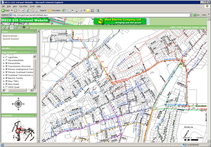 Parcel information and circuitry map is served on MECO's GIS intranet Web site. |
Using his basic knowledge of Microsoft Windows Server, Microsoft Internet Information Services (IIS), and Microsoft Active Server Pages (ASP) development, Abe created an application for sharing mapped assets information on the company's intranet. "I like delivering applications through the Web browser because it eliminates the need to install client software," Abe said. "The user just needs to point the browser to a particular URL and is instantly connected to the map."
Using an application wizard, Abe created a simple mapping application in which, after he provided a fifteen-minute training session, users could navigate through maps and data. He also customized the application to add a search-and-query capability for the underlying parcel and road GIS data.
"Following the initial implementation of ArcGIS Server, I could see the potential scalability of the product for storing and sharing GIS data within the enterprise," said Abe. "We took a systematic approach in selecting a product and developing the deliverables in this pilot phase of our GIS. ArcGIS has worked out as the ideal solution. When I took on this project, I knew very little about GIS, but with Esri training and support I feel that we have made considerable progress in getting our facilities mapped. Esri's Honolulu office, as well as Esri's utility and tech support staff, have been instrumental in our success to this point. I know that Esri has some very large electric customers, but they treat me as though I am just as important as the big guys."
MECO serves approximately 65,000 customers on the three islands that comprise the County of Maui (Maui, Molokai, and Lanai) in the state of Hawaii and is a wholly owned subsidiary of Hawaiian Electric Company, a public utility.