NOAA's GIS-Enabled Web Site Helps Resource Managers Navigate Legislation
By Matt Freeman, Esri Writer
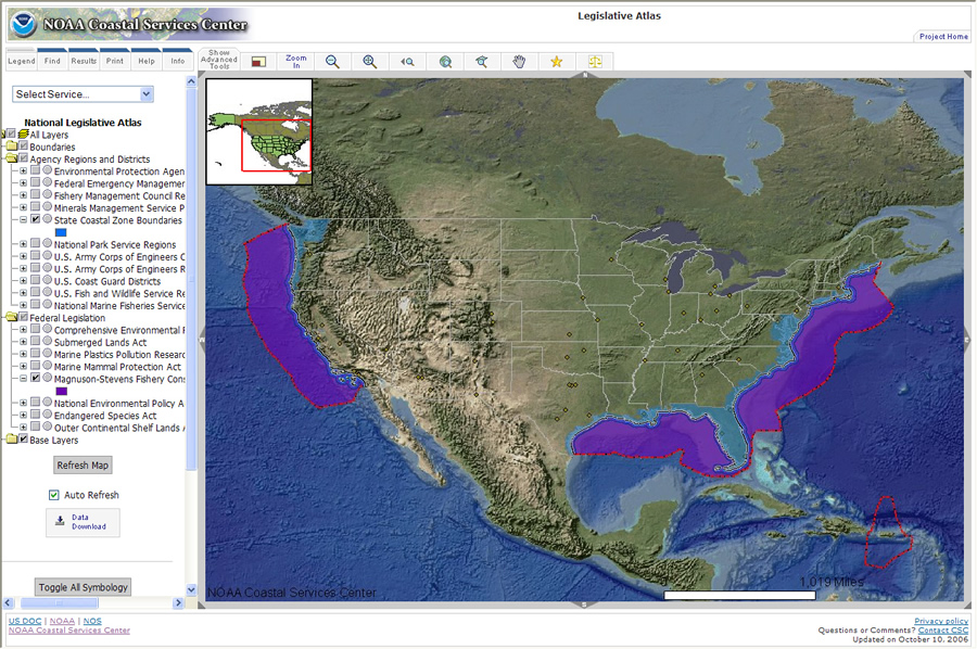 The Legislative Atlas searchable Federal Data Viewer returns State Coastal Zone Boundaries and their spatial relation to the Magnuson-Stevens Fishery Conservation Act. |
Ocean and coastal management involve a complex and multi layered system of laws, organizations, and strategies. Authority is fragmented among a variety of federal, state, and local agencies, which can result in redundant efforts, inefficiency, and confusion. In 2004, the U.S. Commission on Ocean Policy recommended a series of fundamental changes to improve the management of the United States' coastlines.
The commission, established under the Oceans Act of 2000 and with a membership appointed by the president, recommended revisions at the national level and established regional ocean councils to encourage regional collaboration. The commission also recommended forming regional ocean information programs to provide easy access to current research, ocean observations, and other information and tools to inform decision making.
Based on these recommendations, the National Oceanic and Atmospheric Administration's (NOAA) Coastal Services Center (which works with other federal agencies to bring information, services, and technology to the nation's coastal resource managers) set sail with the geographic information system (GIS)-based Digital Coast: Legislative Atlas (www.csc.noaa.gov/legislativeatlas/).
The innovative Web site allows resource managers to better understand the complex legal jurisdictions and regulatory framework of the nation's oceans and coasts by visualizing information in a dynamic, custom-built, Web-based mapping application.
Linking Maps and Laws
 From the Legislative Atlas' mapping application, users can navigate to a database of coastal and ocean laws, view detailed summaries of each law, or further refine their query with a number of search options. |
Created and managed by a team of six people at the Coastal Services Center, Legislative Atlas gives users the ability to view the geography associated with ocean and coastal laws and the potential relationships that exist between these laws. The atlas is available to the public but targets resource managers involved in regional ocean management and related initiatives at the federal, state, and local levels.
Legislative Atlas provides access to geospatial datasets that represent the spatial footprint of ocean and coastal laws. When using the atlas, resource managers can query and view the spatial relationships between legislation and other pertinent marine boundaries to analyze gaps and overlaps in a region's regulatory framework. The atlas also contains the regions, districts, and planning areas of federal management agencies with respect to ocean and coastal activities. The ability to visualize these planning areas helps resource managers identify contacts within federal agencies for a particular area of interest.
Using ArcIMS, the Coastal Services Center and Florida-based geospatial solutions company Photo Science created the atlas as an easy-to-use, dynamic mapping tool for managers with little or no exposure to desktop GIS technology. Resource managers with experience and access to desktop GIS software can download the spatial data presented online.
Legislative Atlas also features a database of relevant coastal and ocean laws that are geographically searchable. Using the mapping application, resource managers can search federal and state laws and read summaries of each law via links to the supporting U.S. codes or state statutes. The search can be refined by state, region, management issue, or federal agency of interest.
"We used to plow through piles of federal statutes in order to find the statute we were looking for and then match it to the appropriate boundary," explained Henry Norris, Fish and Wildlife Research Institute, Florida Fish and Wildlife Conservation Commission. "We have boundaries in our own GIS holdings, but we don't have the statute tied in with the boundary, and that is what Legislative Atlas offers. It's one-stop shopping. We find the area that the statute applies to and then the statute itself on the same Web site. The atlas also saves time by defining the statute. It's pretty quick."
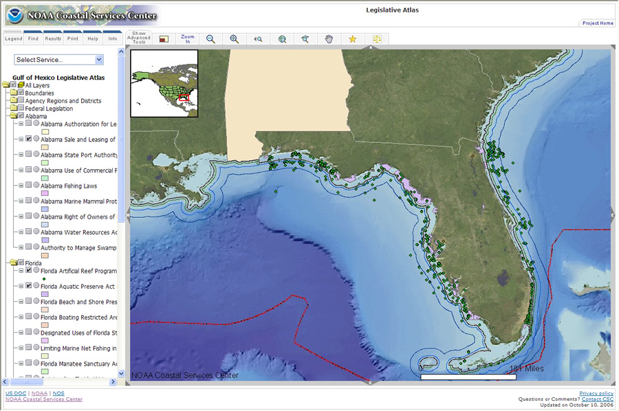 Users can view multiple layers of boundaries and legislation on one interface. |
In one instance, a colleague phoned Norris from an off-site meeting looking for information regarding the Submerged Lands Act, its boundary, where the boundary crossed Florida waters, and under what agency's jurisdiction it fell. Using Legislative Atlas, Norris was able to find the boundary, link it to the legislation, and define the area as his agency's jurisdiction. "It took a couple of minutes to find it all," said Norris. "The Legislative Atlas probably saved me about an hour in that case because normally I'd have to use multiple resources for all of that information."
Although Norris located the geospatial data and statute he was looking for, the atlas' legislative index is far from complete. Prioritizing the relevant legislation that gets mapped is a lengthy process for each region. Continuing to develop the Legislative Atlas relies on collaboration among and targeted outreach to regional councils, resource managers, and NOAA staff. Due to the project's giant scope, new data will be added in milestones. Currently, federal laws are available for most of the continental United States, and state laws are available for the Gulf of Mexico region. The next release of data, scheduled for fall 2008, will include federal laws for the entire United States, including Hawaii, Alaska, the Great Lakes, and Pacific and Caribbean Islands; and state laws for California, Hawaii, Maine, New Hampshire, and Massachusetts. State laws for other regions, including Oregon and Washington, are scheduled for release in 2009.
"Regulations, ordinances, and rules are inherently spatial," added Norris. "They all have boundaries. One rule applies up to a certain line. Beyond that line, another rule applies. For resource managers, rules are a logical thing to see in a map environment."
For more information on Digital Coast: Legislative Atlas, visit www.csc.noaa.gov or contact Adam Bode at adam.bode@noaa.gov.