No Debate about GIS on Campus
By Karen Richardson, Esri Writer
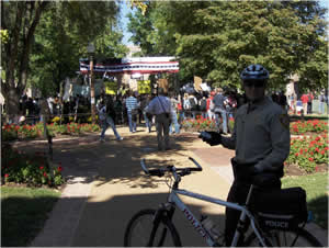
 The 2008 Vice Presidential Debate Common Operational Picture (COP) was created in two weeks with the assistance of Washington University, St. Louis County Emergency Management Services, and Esri. Officials could use the application to pan a map of the campus, zoom in to a specific area, and call up information about buildings. |
When Washington University, in St. Louis, Missouri, offered its Field House as a venue for the 2008 United States vice presidential debate, university officials had no idea the event would be one of the most watched in television history. Approximately 70 million American viewers tuned in on October 2, 2008, to see Governor Sarah Palin of Alaska, the first female vice presidential nominee for the Republican Party, square off against Senator Joe Biden from Delaware, a 36-year veteran of the U.S. Senate.
However, the private university, founded in 1853, is no stranger to the spotlight, having hosted more national election debates than any other institution in history. The school was chosen to host the 1992, 1996, 2000, and 2004 presidential debates. While it's an honor, planning these affairs is laborious and detail oriented.
Ensuring that the debate went off without a hitch was the responsibility of University Facilities. The department needed to coordinate many events before and during the day of the big event. University and vice presidential debate staff needed a solution that would allow them to view and manage all activities to ensure the proper security details and safe crowd control. To do this, they turned to geographic information system (GIS) software from Esri, which would provide the ability to visualize the entire campus and all the activities happening for the debate in real time. GIS allowed them to
- Visualize where all police were on campus.
- Plan and monitor public viewing areas, speakers, and live media broadcasts.
- Manage campus closures, class relocations, and traffic flow.
 Security dispatchers and university officials and other VIPs kept tabs on where barricades were being placed, traffic was being detoured, and security details were being posted. Photo by Aaron Addison/Washington University. |
"Hosting the vice presidential debate meant we had to get a complete picture of all the campus facilities and how the events would play out," said Aaron Addison, university GIS coordinator, Washington University. "In the past, paper maps were used to plan and coordinate on the day of the event. We knew we could do better than static maps and had a vision to provide faster, better access to information in a more accurate manner."
The university holds a site license for Esri GIS software, teaching several courses with the technology as well as using it for campus mapping projects. Since a repository of facilities information was already stored in ArcGIS format, Addison's thought was to find a way to tap into this data to plan for and execute the debate.
Innovative Thinking Leads to Interactive Application
Addison had attended the Esri International User Conference (Esri UC) in the summer of 2008 and saw a demonstration of the ArcGIS API for Flex. "I was impressed with the software's ability to display map information quickly over the Web," said Addison.
ArcGIS API for Flex is a development framework integrated with Adobe Flex Builder 3. Using the Flex API, available free from the ArcGIS Resource Center, developers can combine Web services from Esri's ArcGIS Server with other Web content and display it in simple, dynamic mapping applications over the Internet. Using ArcGIS services, users can transform their local data into a visually rich interactive map, query and display GIS data features and attributes, locate addresses, identify features, and perform complex spatial analytics.
At the time of the Esri UC, the ArcGIS API for Flex hadn't been released. Working with Esri's St. Louis regional office, the university customized a beta copy of the software to create an application to deliver a real-time view of the campus and activities during the debate.
 Officer location information was available via a geoRSS feed that received coordinates from GPS-enabled phones. The phones were donated for the day by Sprint. Photo by Aaron Addison/Washington University. |
The application, which the university called the 2008 Vice Presidential Debate Common Operational Picture, had to be useful for the university afterward to help justify the expense. Receiving funding for creating the application was based on implementing the technology for projects following the October event. "We had an immediate need in our own campus police department and, of course, our Facilities department also showed interest," said Addison.
Collaboration Was Key
Finding useful data was important. Imagery for the entire region was downloaded from ArcGIS Online and fused with high-resolution aerials of the campus that the university gets each year. The St. Louis County Emergency Management office, along with Addison and his team, loaded necessary detailed vector information including streets, places of interest, university facilities, and street data. The university also coordinated with the city and county of St. Louis, both Esri GIS users.
This collaboration was important since the university spans both county and city lines. While the east entrance is located in the city, the west entrance is located in the county. Ensuring data was accurate and worked together made logistics planning possible.
"We had to coordinate with both the St. Louis city and county security for road closures and barricades as well as people staging [and] bike mounted police and officer stationing," said Brad Averbeck, Facilities manager, Washington University. "The fact that both were standardized on the same platform made what could have been a headache of a task into something very manageable."
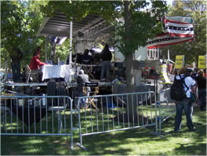 University Facilities ensured that every building and street at the university was safe and secure for the events that took place around the debate, including live media newscasts. Photo by Aaron Addison/Washington University. |
Within two weeks of receiving funding for the project, the 2008 Vice Presidential Debate Common Operational Picture was complete and ready to go. Using the application meant the university could provide the necessary maps on the day of the event, but not in the traditional way. "We were worried about past debates where we would print 60 or 70 maps on the event day but, between delays and changes, they weren't very useful for security," explained Addison.
Keeping an Eye on the Debate
Instead, police officers and VIPs kept tabs on where barricades were being placed, security details were being set up, and traffic was being detoured by viewing mapped information in real time through the ArcGIS Flex application. During the debate, two rooms on campus were open for viewing the digital maps: a communication area filled with police officers coordinating activities and a joint operations center (JOC), where everyone from police commanders to event coordinators and security managers could watch what was happening in real time on campus.
The groups used the same interface, which was kept simple and easy to understand since there was no time for training. Viewers could zoom and pan to see locations as well as click on icons to find more detailed information. For example, clicking on a building would provide information about that building such as the number of rooms and emergency exit information.
Officer location information was fed into a geoRSS feed that received coordinates from GPS-enabled phones donated for the day by Sprint. Clicking on an icon of a police officer on the map brought up a list of information including the officer's name, scheduled shift, and assignment. Officers also used geoRSS to update viewers if security details changed, such as road barricades being moved.
The 2008 Vice Presidential Debate Common Operational Picture kept everyone updated on the debate staging. The data that was required was readily available, and there was no wait time to get questions answered or understand emergent situations. A St. Louis police officer commented, "This is the closest thing to 'CSI' I've seen that actually works."
Recycle, Reuse, Redeploy
Today, the Flex application has been modified and redeployed. Two important areas where the application is used include the university's police dispatch and University Facilities. Campus police dispatchers use an application that's a modified version of the 2008 Vice Presidential Debate Common Operational Picture for emergency situations. Aerials and building footprints are available in the system through a secured connection. Officials can access information about buildings that might be necessary in an event like a fire or hostile situation. By clicking on a building, information comes up instantly, including the names of primary contacts and structural component information such as the location of doors and whether there are lobbies in the buildings. Fire exits and handicap access can also be found, along with what kind of power sources are available and where equipment like water and electricity shutoffs are located.
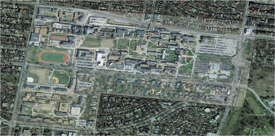 Imagery for the entire region was downloaded from ArcGIS Online and fused together with high resolution aerials of the campus that the university flies each year. | |
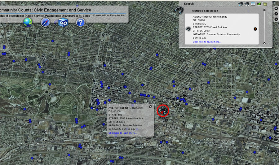 Washington University plans to launch several projects using the application created using ArcGIS API for Flex. One application will show where students and faculty perform community service on campus. |
University Facilities uses the application to accurately see campus information in one place, covering all buildings ranging from new construction to historic buildings dating back to the early 1900s. Viewing utilities helps with maintaining new building plans and keeping an accurate record of the land use. Having information accessible via the Flex-based ArcGIS application—instead of through handwritten notes on the margins of paper drawings or locked in the heads of engineers—has led to many successful endeavors. When a contractor removed several light poles but didn't remove the wiring, the university was able to look at historic maps digitally, easily relocate the wiring, and replace the lights.
Sky's the Limit
Using the current GIS system, the university plans to launch several projects based on the success of how GIS was used for the debate. Using ArcGIS API for Flex enables campus administrators to provide emergency notifications to students for real-time events such as inclement weather, building closures, and safety notifications. Routing student records, maintaining compliance with the Americans with Disabilities Act, and creating campus walking tours are other projects the university looks forward to implementing.
Will the university continue its long and storied hosting of public events, which began in 1904 with the first Olympics played in the Western Hemisphere? "I don't see why not," said Addison. "The university has been selected to host [debates] for five consecutive elections. I can't wait to see what GIS innovations are available to us for the next one."
For more information about how Washington University uses GIS, contact Aaron Addison at 314-935-6198 or via e-mail at aaddison@wustl.edu.