Singapore Masters Land-Use Planning Using GIS
By Matt Freeman, Esri Writer
 Singapore's Urban Redevelopment Authority uses GIS for its short- and long-term planning of the Marina Bay cityscape. |
Singapore faces immense challenges in its land-use planning that stem from the fact that almost five million people live and work within a land area of 710 square kilometers (274 square miles). Given its small size, it's important to carefully plan for the economic growth and future development of the island nation. That's why Urban Redevelopment Authority (URA), Singapore's national land-use planning agency, relies on GIS to find new ways to minimize development constraints.
The result of the URA's GIS-based planning can be seen in two key plans, the concept plan and the master plan, both of which provide a comprehensive, forward-looking, integrated framework for sustainable development.
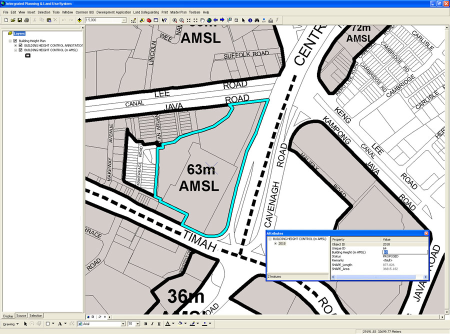 The master plan came to fruition through careful GIS-based planning and design, such as seen here in the Building Height Control layer. |
Esri's ArcGIS Server and ArcGIS Desktop software was used to create the plans, while the ArcMap application inside ArcGIS Desktop was customized to fit the workflow needs of the URA. The new workflow system has enhanced productivity through better data integration and more accessibility than had been provided by the CAD system that URA abandoned in 2006. Since switching to a server GIS platform in that same year, more URA employees can access needed data without having to pay for multiple CAD-based desktop licenses. Meanwhile, GIS data is diffused through better access to fundamental workflow tools, such as simple data retrieval services or editing applications.
URA takes advantage of an enterprise GIS called LandNet to obtain the geospatial data it needs to create maps for designing the concept and master plans. Hosted by Singapore Land Authority, LandNet is a server GIS-based repository containing more than 100 layers of geospatial data contributed by more than 14 public agencies. Using the shared data from LandNet and the functionality in Esri's ArcGIS software, the URA can create, edit, and publish concept and master plan maps on the Web for employees and the general public to view. URA has 200 professionals working on the master plan alone, all of whom can access data concurrently.
The master plan is a land-use plan that guides Singapore's development 10 to 15 years into the future. It is reviewed every five years and translates the broad, long-term strategies of the concept plan into detailed plans to guide development. Like the concept plan, the master plan is produced collaboratively among many government agencies in Singapore.
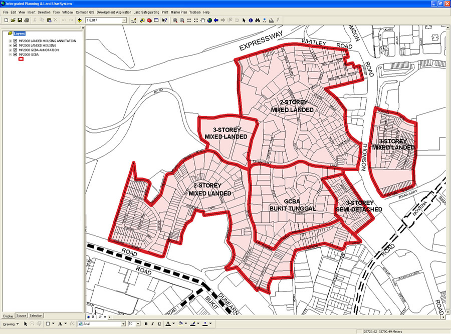 The Landed Housing Areas layer is URA's desktop application for visualizing the height of residential structures. |
The 2008 master plan is unique in that it took suggestions from Singapore's citizens into consideration before it was finalized. Since the URA could easily publish maps and plans on the Internet, the agency invited the public to give feedback on the rough draft of the master plan. From May through August 2008, more than 40,000 people visited the master plan Web site to view and comment on the GIS maps of the master plan.
The concept plan is Singapore's strategic land-use and transportation plan to guide development 40 to 50 years into the future. This long-term plan, which will be analyzed and reviewed every 10 years, ensures that there will be sufficient land to meet anticipated population and economic growth and provide a good living environment. It also ensures that future development will balance economic growth with environmental stewardship and social progress.
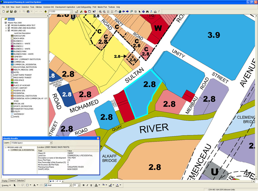 In the desktop environment, the master plan contains a land-use layer, which has assigned attributes to each parcel and polygon. |
"There is great value in the ability for citizens to quickly access the maps to determine planned land use surrounding their properties," says Tan Chia-li, URA senior planner. "For average citizens, the master plan is a glimpse into their future. They can envision their community, their nation's progress, and development down to the block level. The master plan lets people peer through a window five years into the future."
For the past 40 years, Singapore has prided itself on sustainable development, which has allowed it to achieve the economic growth that citizens appreciate. By planning ahead and balancing land-use needs, land-scarce Singapore believes it can continue to meet development and economic objectives without sacrificing a good quality of life.
For more information, contact Goh Chye Kiang, senior systems analyst, Singapore Urban Redevelopment Authority, at goh_chye_kiang@ura.gov.sg, or Tan Chia-Li, senior planner, Singapore Urban Redevelopment Authority, at tan_chia-li@ura.gov.sg.