ArcWatch: Your e-Magazine for GIS News, Views, and Insights
December 2011
4-H Clubs' GIS Projects Support Science and Technology Training
Members Prepare for Future Education and Employment
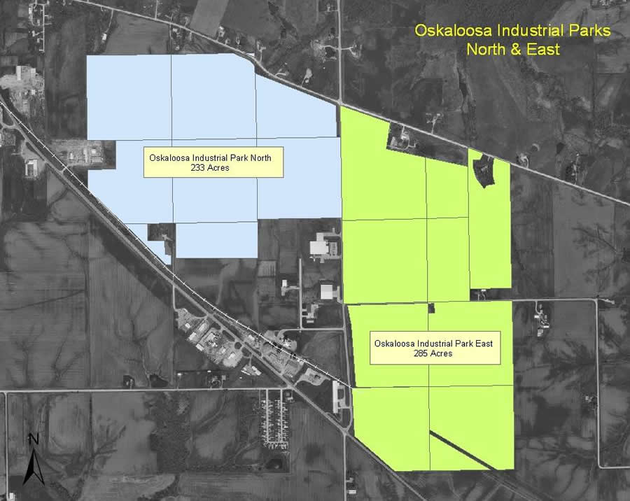
Students who belong to the 4-H Southeast Area Tech Team created this map of two industrial parks in Oskaloosa, Iowa.
Supported by grants from Esri, 4-H clubs across the United States are launching geographic information system (GIS) projects to help young people get a better grasp of science and technology and enrich their communities.
"GIS technology contributes to the 4-H science program goals because it teaches youth about a technology that most have never used," said Jim Kahler, a 4-H program specialist at the United States Department of Agriculture (USDA). "They also learn more about the subject that they are mapping—plants and animals, wildlife, natural resources, or historic places. GIS is also a good tool to integrate with other 4-H content areas, such as nutrition and health, citizenship, and communications."
A. B. Graham, a school principal in Springfield, Ohio, is credited with starting what was to become the 4-H club. In 1902, motivated by the large numbers of young people who were leaving their farms for work in the city, Graham began promoting after-school programs to educate youth in the practical arts of scientific agriculture, such as improving crop harvests and safely preserving food. The national 4-H organization was officially formed in 1914, when the United States Congress created USDA's Cooperative Extension Service, consolidating various boys' and girls' clubs that were involved with agriculture, home economics, and related subjects.
Later, the 4-H after-school curriculum was expanded to include technical programs, such as the 4-H Science Initiative, which supports the science, technology, engineering, and mathematics (STEM) program the US government implemented to improve the science and technical skills of elementary- and secondary-school students.
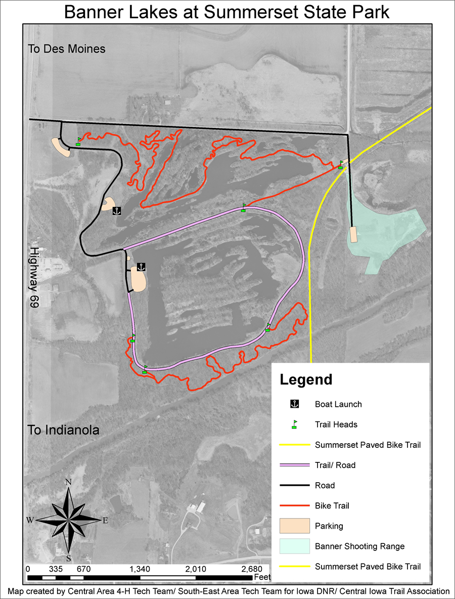
The 4-H Central Area Tech Team and Southeast Area Tech Team worked together to create a trail map for Summerset State Park in Iowa.
The goals of the 4-H Science Initiative and STEM program are being promoted through projects such as the USDA Economic Research Service's Food Environment Atlas. For this project, 4-H clubs collected data regarding the availability of wholesome food within their communities.
Members of 4-H clubs have also worked with local US Fish and Wildlife Service professionals, mapping wildlife refuges and identifying areas of concern for future environmental monitoring. Students in the clubs have also mapped invasive weed infestations and assisted with local disaster preparedness plans. These projects allow club members to improve their STEM skills and meet 4-H requirements for community service projects.
Since its inception in 2004, the 4-H GIS software grant program sponsored by Esri has helped more than 725 4-H clubs begin and sustain GIS programs for their members. Esri has made grants available for ArcGIS software and Virtual Campus training. Learn more about 4-H and GIS.
"The GIS software grants have empowered 4-H youth to take an active role in researching and investigating their communities," said Esther Worker, who manages Esri's informal education activities. "4 H youth are learning about community, technology, and careers as a result of their GIS service learning projects."
Another benefit derived from the relationship between Esri and 4-H is the opportunity for the 4-H national GIS/GPS leadership team to send delegates to Esri's annual Education User Conference (EdUC). The team comprises selected 4-H youth and adult mentors from across the United States. "At the EdUC, they participate in local mapping projects, attend sessions and workshops, and present the projects they have been working on during the preceding year," Worker said.
Debbie Stevens, adjunct professor at William Penn University, has been a volunteer with her local 4-H club in Oskaloosa, Iowa, for more than six years. The area has a long history with 4 H, and many current members have great-grandparents who were once in the same local club. Because 4-H is a traditional part of community life, Stevens has been successful in raising money from local businesses for funding special projects, such as buying the equipment needed for the club's mobile technology lab.
"Our community leaders didn't know much about GIS at the time, but because we were focusing on the benefits to youth and using emerging technology, prominent businesspeople supported the project and had faith that our 4-H youth would benefit, as would our community," Stevens said. "We were able to purchase 10 laptops, a wireless printer, a digital camera, and a GPS kit [with 10 Garmin eTrex units and 10 compasses]."
Since Stevens' involvement with the club, the local 4-H Southeast Area Technical Team (SEATT) has completed a number of GIS-based community projects that include
- Plotting the locations of industrial properties available for economic redevelopment
- Creating trail and facility maps in local recreational areas
- Mapping cultural, retail, and commercial downtown districts for the Oskaloosa Chamber of Commerce
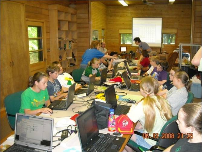
Students from 4-H clubs in Iowa work on their GIS mapping projects.
The group will soon work with Oskaloosa officials to conduct a citywide inventory of all ash trees. The data collected will be used to institute an abatement program in the event of an emerald ash borer infestation. The emerald ash borer is a highly destructive insect that was first detected in the United States about 10 years ago and has spread rapidly since that time. The data collected by the 4-H group will also be made available to the USDA Animal and Plant Health Inspection Service (APHIS), which is coordinating a national effort to minimize the ecological impact of this invasive insect.
The club also maps the locations of local hog confinements, referred to as confined animal feeding operations (CAFOs) and found throughout rural farming areas. Mapping these sites provides critical health and planning information for the community, as hogs living in confined areas produce excessive amounts of excrement that decomposes into various types of particulate matter and toxic gases, including ammonia and hydrogen sulfide. When these gases are released into the atmosphere, they can be detrimental to the health of people living nearby.
"This is the information age, and it is critically important for youth to learn IT skills," said Stevens. "I can think of no better information management system than GIS—all pertinent information is stored in tables directly related to locations on a map. The map is used to paint a picture with that data. Whether it is about climate or transportation, a map is much easier to read and understand than the related spreadsheet.
"So, when you can connect young people to an activity that is relevant in nearly any career path—transportation, government, business, science, conservation, environment, education, agriculture, emergency planning, forestry, firefighting, community planning, health care—and the application is fun, you can't lose!"