ArcWatch: GIS News, Views, and Insights
December 2012
SeaSketch Launches
Collaboration Platform Brings Ocean Use Planners Together

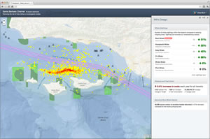
Using SeaSketch, whale conservationists can show the nominal cost of rerouting shipping lanes away from whale migration areas.
People who manage the ocean's resources now can use a friendly, intuitive tool to help them understand ocean resources and work together to create ocean use plans. The newly released SeaSketch application will be used by environmentalists, natural resource enterprises, shipping companies, and others, to design plans that will help people maintain a sustainable relationship with the ocean.
SeaSketch was designed by researchers at the University of California, Santa Barbara (UCSB), McClintock Lab. Esri provided funding and support to develop the tool as part of the Esri Ocean GIS Initiative.
An agency that buys a SeaSketch subscription from UCSB can set up an online workspace and invite planners and stakeholders to design and study plan elements such as marine protected areas, aquaculture sites, and permitted fishing.
The United Nations Environment Programme Conservation Monitoring Centre (UNEP-WCMC) will soon start to use SeaSketch as a central technology. The center will initially use the tool to create a dialog among businesses, organizations, and governments regarding the use of the high seas, which is the area beyond jurisdictional waters. The center expects to see cost reductions in travel and time for its clients but, more important, an increase in collaboration, too.
"SeaSketch is a great step forward in interactive marine spatial planning," said Damon Stanwell-Smith, acting head, marine assessment and decision support program of UNEP-WCMC. "We will use it to get people talking about sustainable ocean management and to consider ocean biodiversity in their ocean use projects. Working on the platform, we can have a discussion in the same room or on another continent." Esri's ArcGIS Online plays a major role in SeaSketch by providing a platform for project managers to discover an enormous amount of geospatial data that may be helpful for their projects.
Because SeaSketch incorporates Esri's ArcGIS web development technology, project managers can easily move from ArcGIS environments into SeaSketch. Organizations can leverage existing investments in ArcGIS by directly pulling published map services into SeaSketch, ensuring the application uses the most current data available.
Adding GIS tools and applications to SeaSketch extends its capabilities. For example, adding the Esri and National Oceanic and Atmospheric Administration's (NOAA) Benthic Terrain Modeler (BTM) gives users a set of geoprocessing tools to analyze benthic terrain and classify surficial seafloor characteristics.
"Helping people make better decisions in the environmental space is extremely important to me," said Jack Dangermond, president, Esri. "Our support of the UCSB SeaSketch project is a component of the Esri Ocean GIS Initiative, which allows people to positively impact the future through a deeper, geographic understanding of the ocean."