Benefit Migrating Birds and Farmers
In response to the decline of wetland habitats for migrating and wintering water birds in California, The Nature Conservancy (TNC), an international conservation organization, has developed a program called BirdReturns. The program creates “pop-up” wetland habitat where and when birds need them most by enlisting farmers to flood their fields at specific times.
California’s Central Valley has lost more than 90 percent of the four million acres of wetlands that at one time supported an estimated 40 million wintering waterfowl. Birds now depend on a patchwork of refuges, protected areas, and farmland for their habitat needs.
Protected area strategies, such as buying land that could be restored to wetlands in perpetuity, can be prohibitively expensive, and the number of willing sellers is limited. BirdReturns is a complementary approach that combines precision science to pinpoint where and when birds need habitat with market tools to pay farmers to generate habitat.
How It Works
Working in partnership with Cornell Lab of Ornithology and Point Blue Conservation Science, TNC uses predictive models of water bird occurrence and abundance and surface water availability to target times and places predicted to have high bird occurrences and abundances but lack habitat availability. Since piloting the program in the spring of 2014, BirdReturns has targeted shallow water habitat for shorebirds from February to March and from mid-August to October. These are time periods when predicted shorebird needs are great but appropriate habitats may be in short supply.
Farmers are invited to participate in a reverse auction. They submit bids for the cost of providing habitat in two-week increments in spring or fall. TNC processes bids by geolocating each field and evaluating bids based on price per acre, predicted bird occurrence model scores, distance from refuges, protected areas and other bids, and other factors. The goal of the evaluation process is to provide the greatest value of high-quality habitat for the least cost. The bids with the best conservation return on investment are selected. Farmers with winning bids are enrolled in a program that will pay them if they create the proposed habitat by flooding their fields. TNC monitors the habitat created and the number of birds that use the habitat.
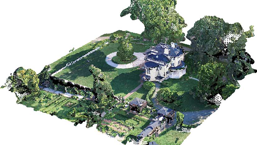
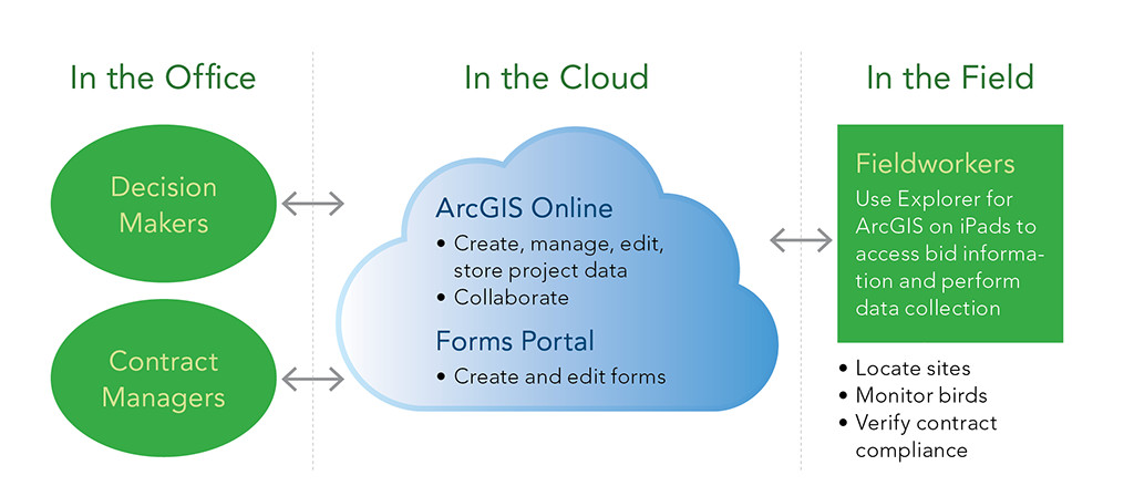
TNC relies on a suite of geospatial, cloud, and mobile technologies to implement the BirdReturns program efficiently—from ArcGIS Online for collaborative web mapping and program design to the Explorer for ArcGIS app, which supports the field teams with an interactive mobile map, to digital forms that are used by field teams to collect data on mobile devices.
A Spatially Explicit Auction
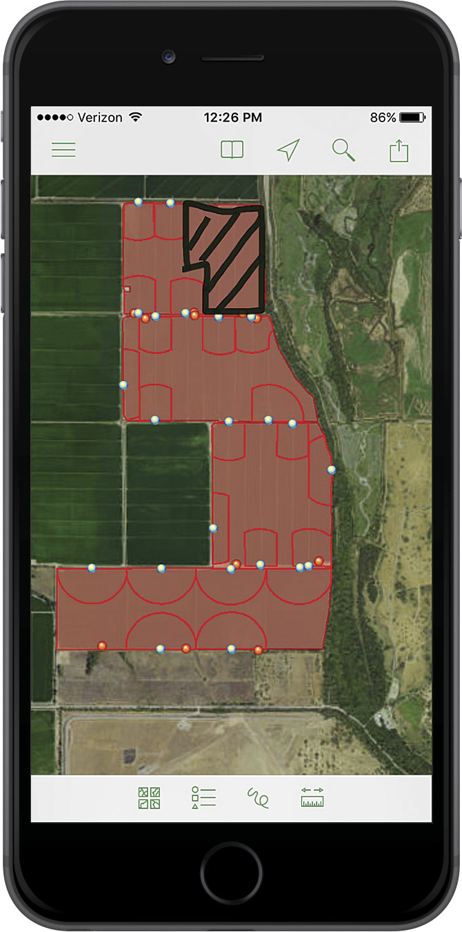
During the reverse auction, bidding farmers provide information detailing the number of acres, cost per acre, location of the fields, and how long they would like to provide this habitat. An online web map is used to support the transfer of bid information into a GIS data layer using ArcGIS Online. TNC staff are able to work simultaneously, digitizing bid locations and verifying information provided by BirdReturns auction participants. The selection process is supported by analyzing various ecological metrics to identify the most competitive bids.
Metrics include distance to high-probability surface water, predicted mean abundance of shorebird species, predicted mean probability of shorebird species, probability of bid sites having surface water present during time-specific periods, and distance to airports. The bid GIS data layer is then used as a zonal layer to extract the various ecological metrics reflective of each bid location. The summary statistics are used to generate relative indexes to support the ranking of each bid.
The BirdReturns team reviews the bid locations via an ArcGIS Online web map application in conjunction with the ranked ecological metrics. The ArcGIS Online web map application provides an efficient method for team members, who are located in remote offices, to collaboratively review the data in real time and visually assess the field characteristics using Esri’s online imagery. They can quickly make determinations concerning which bids should be prioritized for further assessment.
Monitoring Response and Compliance
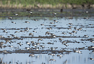
Once auction bids are selected, it is critical to determine the response of the shorebird populations to the newly created habitat. Which species are present, and what are their relative abundances over different temporal periods and site conditions? To answer these questions, avian monitoring technicians must visit each site and collect detailed information on bird use and site conditions.
Drawing meaningful conclusions from this data requires a statistically robust sampling design. TNC generated sample points using a Generalized Random Tessellation Stratified (GRTS) procedure that maximally disperses points to increase the probability that sample points are statistically independent and less likely to be biased. To achieve this, ArcGIS Online provides a mapping environment that supports field monitoring teams and is accessed using the Explorer for ArcGIS mobile app. The mobile web map includes data on bid locations, sampling point locations, associated monitoring zones (monitoring zones extend in a 200-meter radius from each sampling point), and aerial imagery. Armed with iPads, field monitoring teams are able to navigate to each monitoring location using Explorer for ArcGIS, which displays street names. Teams verify program enrollment, landowner, and sampling point information, accessing it from map pop-ups. They also install monitoring stakes and conduct bird surveys and site condition and compliance monitoring at recurring intervals.
Optimizing Bird Surveys
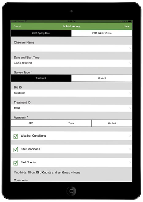
Historically, TNC—as well as most other organizations conducting field research and monitoring—has used paper surveys to record field observations. Once staff returned from the field the data was transferred to computer spreadsheets. However, there was strong interest in having this information recorded in a digital format from the onset of monitoring so that it could be uploaded to a central data location accessible by the BirdReturns team.
This reduces time spent on data entry, as well as recording and transfer errors, while improving efficiency in the field and reducing the amount of material that field staff have to carry. To facilitate this, TNC used a form-building application that was cloud based but also allowed for data collection offline. Using this application, existing paper format bird survey documents were transferred into a series of logically linked, cascading digital survey forms.
Field staff verified bid location and sampling point ID numbers using Explorer for ArcGIS and selected this information in the digital survey form app. Once a bid ID is selected, the survey form app incorporates drop-down boxes that provide a list of monitoring IDs relevant to that particular bid ID. This functionality aids staff by improving the efficiency and accuracy of data recording. Field staff are then led through a structured workflow that enables them to quickly enter observations and save them to the iPad.
In addition to recording bird observations, monitoring teams review field conditions, such as water depth and the spatial extent of habitat, to determine auction contract compliance. The Explorer for ArcGIS app enables staff to quickly draw regions that were out of compliance, estimate acreage affected, and send screen captures from the devices back project management staff who can bring these fields into compliance. Once observations were recorded, staff members send the data to cloud storage, where the BirdReturns team begins working with it.
Conclusion
Implementing the BirdReturns program involved significant efforts in data development, management, and collection over a wide geographic area. It necessitated quick response to changes in data and required making the data available to distributed field teams, decision makers, and contract managers in the office. The use of cloud and mobile geospatial technology has allowed TNC to successfully implement five seasons (or more than two years) of BirdReturns. The program has grown each season, which is significant because BirdReturns will need to scale up the program to support the millions of migrating water birds that face increasing challenges in finding suitable forage habitat.
The BirdReturns program, which has completed over two years of implementation, has yielded more than 40,000 acres of temporary shorebird habitat at times that are critical to support migrating shorebird populations. Shorebird populations have significantly responded to the habitat, which has generated increased interest in scaling the program to provide habitat to additional regions within California and beyond. The utilization of a variety of mobile geospatial and data collection solutions enabled TNC to develop and implement a monitoring program that has improved in-field collection processes, reduced the turnaround time for data to be accessible for analytics, and provided an approach that is durable through time where various platforms can be easily replaced or supplemented with new technologies as they emerge.
For more information, contact Katie Andrews.