ArcUser Online
|
Firefighters Pioneer Pocket-Sized GIS Collection by Russ Johnson, Esri Public Safety Industry Manager |  |
One hundred years ago, the way fire officers displayed their fire protection problems was on Sanborn maps. Drawn by hand, building by building, block by block, they were eventually abandoned because they were too labor intensive. Today fire officers need specific information on fire problems more than ever. And they have a new tool: GIS. �Electronic fire management means using a computer to achieve excellence in fire planning.
Ronny J. Coleman
Retired California State Fire Marshall
Maps are the foundation for fighting wildfires. They are used for communicating operational assignments, potential spread scenarios, and for providing a visual reference for incident team strategy discussion. Maps answer questions such as "What is the topography in and near the fire?" and "What is the jurisdiction of the fire and where is it likely to spread?" Maps help managers deploy resources safely and assess the potential overall damage of the fire.
In the early stages of a wildfire, it is difficult to obtain good detailed information from a paper map. Information is often gathered from maps, documents, and technical personnel over several days. Using GIS, all of this information is immediately available and can be easily viewed and understood under extremely stressful conditions. It is now common to see a GIS team assigned to an incident in the planning section. GIS teams provide maps showing transportation, facilities, air hazards, spread prediction, operations, and other geographically related incident management information.
Dynamic GIS
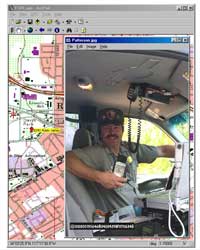
In recent years, firefighters have been using helicopters, GPS units, laptop computers, and GIS software to map the perimeters of wildfires. The technical specialists who perform this type of mapping typically carry a full-sized, 10-pound notebook computer; a GPS receiver weighing several pounds; a cell phone;, and a full complement of extra cables, batteries, and other necessities in a helicopter or on the fireline to provide fire managers with up-to-date information for sound tactical decisions. While these efforts have been very beneficial, juggling computers, cables, and GPS units within the tight confines of a helicopter or truck cab is challenging.
In January of this year, dynamic mapping and GIS were taken a step further and made quite a bit more convenient. While responding to the first major fire of 2001 in Southern California, firefighters digitally mapped an ongoing wildland fire using a handheld PC, ArcPad mapping software, and a GPS receiver.
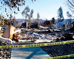
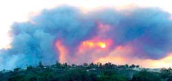
The Viejas Fire was started on January 3 by a careless smoker travelling through San Diego County on Interstate 8. The fire, fanned by Santa Ana winds that gusted up to 65 mph, eventually burned 10, 353 acres in the Cleveland National Forest, destroyed many structures, and required the evacuation of hundreds of residents. Wind conditions coupled with low fuel moisture levels caused the fire to spread across this mountainous area at a rate of three-quarters of a mile per hour. More than 2,000 firefighters from local, state, and federal agencies and 225 engine companies responded to the incident.
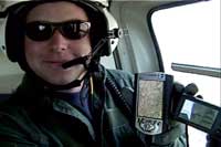
As part of suppression efforts at the Viejas fire, a Tactical GIS Mapping team collected and displayed real-time fire perimeter data and documented damage assessment information by flying daily helicopter reconnaissance flights and recording accurate geographic coordinates using a handheld computer. The team consisted of Tom Patterson, National Park Service; Joe Appleton, Kern County Fire Department; Bob Bower, Bureau of Land Management; and Randy Lyle, California Department of Forestry and Fire Protection.
View a video of the Tactical GIS Mapping Team using ArcPad
"This was the first fire ever that we have mapped with ArcPad," said Appleton. "Our primary object with ArcPad was to map the perimeter. We connected our handheld computer to our GPS unit. The handheld, which utilizes ArcPad, creates a line file as you fly. When you finish flying the perimeter, ArcPad will close that line into a polygon if you select it." Upon landing, these shapefiles were immediately downloaded and used to print maps in the Situation Analysis Mapping center.
Up to the Task
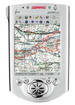
This new system, using a Compaq iPAQ Pocket PC or Hewlett-Packard Jornada with ArcPad mapping software and a GPS receiver, worked flawlessly. A handheld computer can be used with all common GPS receivers by connecting the data cable from the GPS unit into the computer serial port.
Patterson, who teaches aerial mapping using GPS, was pleased with the performance of this equipment configuration. "Total weight of a Compaq iPAQ Pocket PC and a Garmin GPS III Plus receiver is less than one pound, and the entire GIS data collection platform will easily fit into a flightsuit pocket. Everyone who saw it used on the fire took an instant liking to it and remarked at the power in such a small package (and it looks cool!)."
Patterson found that the Compaq iPAQ Pocket PC met the demanding requirements for prolonged fire perimeter mapping. The internal lithium-ion battery lasts 10 to 12 hours, and the color display can be read in bright sunlight. Map data can be stored internally (the unit comes with 32 MB of RAM) or by sliding the iPAQ Pocket PC into a PC card expansion pack. Additional storage, such as the DataPak 2 GB PC Card Type II hard drive from Kingston Technology, and a wireless modem may be used for enhanced flexibility. A Teletype PCMCIA card GPS receiver provides direct connectivity with the computer without a cable. Patterson believes this combination of technologies promises to become a regular fire management tool "as common as the tactical applications of Class A foam."
Appleton sees potential for greater benefit using this system with a wireless connection. This would allow data to be transmitted back to the GIS unit from the air. This capability would enhance firefighter safety. "If division supervisors and operations staff know where the fire is and what is going on with the fire they have a better idea where to put the resources and can make sure those firefighters are safe," said Appleton.
Patterson, fire management officer at Joshua Tree National Park, has worked with other GPS specialists from the National Park Service, Bureau of Land Management, and U.S Geological Survey to develop a one-week training course on using GPS for fire management that is taught at the National Interagency Fire Center (NIFC).
For additional information on the technology used to map the Viejas fire, contact
Tom Patterson, Fire Management Officer
Joshua Tree National Park