Fall 2005
Fall 2005 |
|||||||
|
|
|||||||
The Nature Conservancy Uses Mobile GIS Technology in Fight Against Invasive Species |
|||||||
|
By Jason Karl, Idaho GIS Manager, The Nature Conservancy
As people increasingly travel and ship goods around the world, they may intentionally or unintentionally move organisms from their native ranges and introduce them into new areas. While most of these introductions are not problematic, an increasing number cause environmental and economic harm. Invasive species are those organisms introduced by humans or human activities into environments to which they do not naturally occur, resulting in adverse consequences. Invasive species pose serious threats to natural systems around the world by altering ecosystem processes, such as fire regimes or water availability, and reduce native biodiversity through competition, displacement, or habitat degradation. While a common perception of invasive species is that they mainly inhabit agricultural areas and heavily impacted sites, the reality of the matter is that they are making inroads into even the most pristine natural areas. The Nature Conservancy (TNC), a nonprofit conservation organization working with partners throughout the United States and internationally to preserve habitats necessary to sustain the earth's biological diversity, views nonnative species invasions as a primary threat to global conservation and as having a significant impact not only on unprotected areas but also on parks, preserves, and other conservation areas worldwide. Invasive species are an inherently dynamic and spatial problem—new infestations are being detected, and known ones are eradicated or change in size and density with treatment. In response, TNC's efforts to fight invasive species focus on four strategies: prevention of new invasions, early detection and eradication of new infestations, treatment or restoration of infested sites, and education and outreach to inform policy makers and the public. For each of these strategies, collection and management of spatial information are crucial. Accordingly, mobile GIS technologies offer a tremendous opportunity to aid the fight against invasive species.
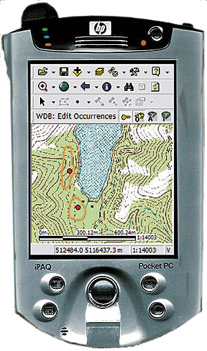
TNC is employing Esri's ArcPad and Application Builder in two efforts to combat invasive species. The Weed Information Management System (WIMS) is a database designed to collect spatial and attribute data about invasive species occurrences and their management treatments. First, data is collected using ArcPad on handheld computers and can be uploaded to a desktop version of the database and integrated with desktop GIS applications, such as ArcView. Second, weed infestations are being mapped from the air with ArcPad on pen-tablet PCs with an approach called digital aerial sketch mapping (DASM). Researchers and developers from the conservancy tested several mobile GIS applications and selected ArcPad for these applications because it provided the best mix of functionality, such as GPS integration and background image display; interoperability with existing GIS data and applications; and customizations, such as data-entry forms and project-specific toolbars. Weed Information Management SystemEven though TNC field staff members have been working for many years to manage and control weed populations, there has been no suitable method for tracking weed management activities at either site or landscape scales. The lack of good, accessible records of the staff's work inhibited the ability to share lessons learned from weed inventory and control efforts and the conservancy's ability to make well-informed management decisions to help prioritize and achieve on-the-ground results. WIMS is a Microsoft Access-based relational database application designed to assist natural resource managers in managing their weed data. Three types of data records are tracked in WIMS: weed occurrences (point locations), assessments (size and status of the weed infestation to facilitate monitoring over time), and management treatments applied to those weed infestations. Users can export data as shapefiles and database tables directly from the WIMS desktop database to a Pocket PC handheld device. In the Pocket PC, they can then take full advantage of ArcPad software's capabilities to navigate to existing weed infestations and monitor changes in weed infestations over time. A custom WIMS applet and data-entry forms developed in Application Builder allow users to enter weed information in the field and capture spatial data through an attached GPS unit or by drawing directly on the screen. Data collected via ArcPad can then be synchronized back to the WIMS database where it can be used to generate reports, track changes, or be exported and sent to other users or applications. An extension written for ArcMap provides for integration of the WIMS database with existing GIS data and projects. Digital Aerial Sketch Mapping
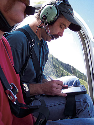
Aerial sketch mapping was developed in the 1940s as a technique for quickly identifying and mapping infestations of forest pathogens and insects. Observers sketched the locations of infestations on paper maps while flying transects over a survey area. With the advent of touch-sensitive computer displays and integrated GIS/GPS software, it became possible to use moving-map displays to constantly show the aircraft location against background data and images and enter survey data directly in the computer. The USDA Forest Service pioneered the DASM variation of this technique in the 1990s and demonstrated that it could produce highly accurate results. TNC became interested in DASM as an alternative to traditional image-based remote-sensing techniques for early detection and monitoring of infestations of invasive plants in the Hells Canyon region of Idaho and Oregon. TNC's DASM system consisted of an Xplore Technologies iX104 C2 rugged Tablet PC with AllVue display running ArcPad and an EMTAC Bluetooth GPS. It used United States Geological Survey 1:24,000- and 1:100,000-scale digital raster graphics as background images to assist in the location of weed infestations on the map display. Vibration and movement of the aircraft often make it difficult to hit small icons and buttons on the Tablet PC screen, so TNC customized ArcPad software's toolbars to list the commonly used tools across the toolbar. It also added custom tools that would zoom to preset levels, as well as show circles of one and five acres on the screen to aid in estimating the size of mapped infestations. Custom data-entry forms made data entry into shapefiles quick and efficient with large text and form controls, making extensive use of radio buttons and drop-down lists. ArcPad software's tracklog feature enabled viewing of the survey's flight path in relation to the survey area to ensure adequate coverage. Although chartered aircraft time can be expensive, the DASM technique allows surveying of large landscapes in a manner that is more cost efficient than either ground-based surveys or other remote-sensing techniques. Additionally, DASM provides a survey method in which TNC can quantify errors (both classification as well as locational) and turn around information much quicker than other remote-sensing techniques. ConclusionArcPad is a powerful mapping application for TNC that is also easy to use and affordable. This should allow land management agencies and other organizations to train existing personnel in these survey techniques for their invasive species survey and monitoring needs. Successful management of invasive species hinges on the ability to prevent infestations and detect and eradicate new infestations before they spread. Additionally, due to budgetary constraints and the expanding threat of invasive species, land managers must constantly seek out the most efficient methods for managing invasive species. Esri's mobile GIS technologies (ArcPad and Application Builder) have helped revolutionize the way invasive species information is gathered and managed, allowing data to be collected and shared more quickly, accurately, and efficiently than ever before—ultimately increasing TNC's ability to combat invasive species. For more information, visit The Nature Conservancy's Invasive Species Initiative Web site (http://tncinvasives.ucdavis.edu/). |