Fall 2006
Fall 2006 |
|||||||
|
|
|||||||
4-H and GIS—A Combination to Spark Imaginations |
|||
|
The image of 4-H youth showing cows, plows, and sows at the local county fair has grown to include 21st century cutting-edge technologies. A typical youth 4-H project today could very well involve youth learning life skills in GIS, GPS, remote sensors, emergency readiness, movie making, food engineering, sports science, Flash animation, robotics, and engineering.
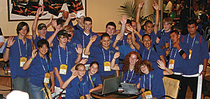
To represent almost 300 4-H GIS clubs in the United States, a team of 4-H adults and youth from 14 states had been selected to attend the 2006 Esri Education User Conference and the Esri International User Conference in San Diego, California. The 4-H delegation was easily recognized by its trademark vivid blue 4-H polo shirt with the green 4-H clover emblem as the members attended sessions and activities. Youth and leaders apply to be part of the National 4-H Technology Team, and those selected for the national team are tasked to learn about a new technology and take back what they've learned to their local state and community clubs. The 4-H'ers attending the Esri conferences had a very full schedule, beginning with a preconference field trip to the San Diego Wild Animal Park (SDWAP) to visit with Mark Houston and Cary Sharp, SDWAP GIS professionals. Then they learned that Houston and Sharp have college degrees in wildlife management and horticulture and have used GIS technology for the past five years to help them plan and manage the resources at the park. Peter Murtaugh (Trimble) and John Johnson (GIS Workshop) met the 4-H group and showed them how to use Trimble GPS units as the 4-H youth would be providing technical assistance to participants in the Education User Conference GeoTreasure Hunt activity the next day. 4-H youth talked about their local GIS community service projects at various sessions of the Education User Conference, as well as participated in the Education EXPO and the GeoTreasure Hunt. The 4-H social on Sunday evening gave interested adults an opportunity to learn more about the 4-H GIS GPS program as the youth talked one on one with guests. The highlight of the Monday plenary session was seeing six 4-H youth on the plenary stage. Kaitlyn, 10, Lauren, 10, and Shelby Kilpatrick, 12, Copper Canyon, Texas; Emma Long, 15, Bergen, New York; Billy Swift, 16, Livonia, New York; and John Trammell, 18, Highland, California, did an outstanding job of telling more than 13,000 conference attendees about how 4-H youth across the United States are making a difference in their communities with the use of GIS technology in their projects. The youth had an opportunity to talk further with conference attendees at the Monday evening Youth Community GIS Special Exhibit in Conservation Hall. Today's youth have an opportunity to learn about GIS technology in after-school youth-serving organizations, such as 4-H, Boys and Girls clubs, Boy Scouts, and Girl Scouts. As these young people learn leadership and life skills, they are also conducting community service projects, often using the new technologies they are learning about. 4-H youth in St. Simons Island, Georgia, worked closely with their communities' emergency services organizations to develop a county evacuation map. Idaho, Iowa, and Nevada 4-H youth involved in community readiness help educate their communities about how families and businesses can prepare ahead of time by having a 72-hour emergency preparedness kit and have worked with local emergency providers to develop evacuation plans and shelter maps. The youth have participated in a number of emergency preparedness tabletop exercises with their police, fire, and ambulance departments. 4-H adult volunteers and GIS professionals mentor 4-H youth to learn life skills related to technology and science, discuss ethical issues, identify career opportunities, and explore applications in daily life. 4-H'ers in Arizona, Colorado, Maine, and Utah are using GIS to help natural resource managers define wildfire and weed control strategies for their local communities. Texas 4-H'ers have integrated GIS technology into their Wildlife Habitat Evaluation Program and are working side by side with the Texas Parks and Wildlife Department to inventory, map, and create trail kiosks along equestrian and pedestrian trails. More InformationMore information about 4-H and GIS may be found at www.esri.com/4-H. |