Fall 2007
Fall 2007 |
|||||||
|
|
|||||||
Collier County Builds Public Utilities Geodatabases |
|||||
Highlights
Larger than the states of Delaware and Rhode Island, Collier has the most land area of any Florida county. Its 2,305 square miles stretch from the Paradise Coast to the state's rural center, covering portions of Big Cypress National Preserve and abutting the iconic Everglades. The U.S. Census Bureau ranks the county's Naples and Marco Island metropolitan area as the seventh fastest growing nationally, based on a 25.2 percent population increase between 2000 and 2006.
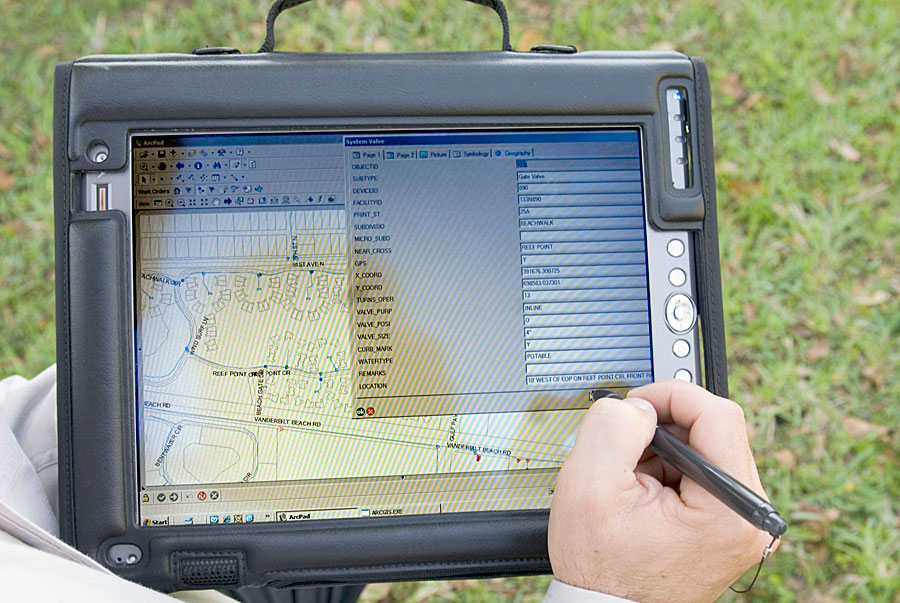
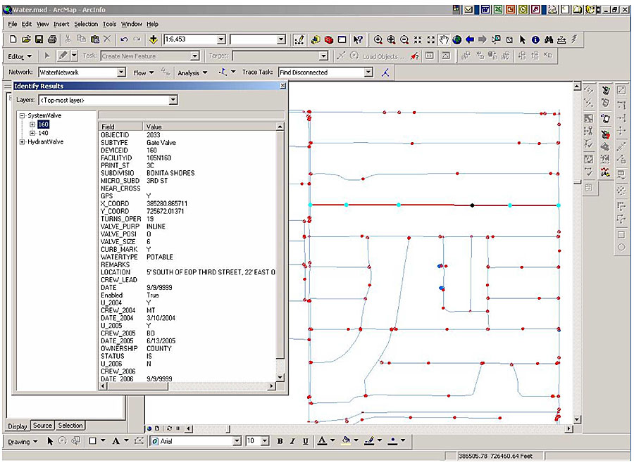
Development, environmental constraints, and other challenges complicate water systems management for Collier County's Public Utilities Engineering Division (PUED). Much of the population (including "snowbirds") lives in low-lying coastal areas subject to storm surges. Meanwhile, extended drought has caused one of the most critical water shortages in Florida history, resulting in conservation mandates and massive water restoration projects. Naples, the county seat, claims to have the most golf holes and millionaires per capita in the country. Unfortunately, well over 50 golf courses strain the local water supply, while one area millionaire set the bar last year by using 38.1 million gallons of water at his private residence. In hindsight, an ambitious, multifaceted GIS project begun in the year 2000 has more than vindicated PUED, which recognized the need for a tool to comprehensively locate, monitor, and manage the county's utilities assets. For consulting services, PUED selected Esri Business Partner WilsonMiller, a Florida-based planning, design, and engineering firm, for its local knowledge and the diverse skills of its GIS team, which allocated extensive resources toward the project's completion. Together, PUED and WilsonMiller developed SDE geodatabases for the county's water, wastewater, wells, and reclaimed water (irrigation) systems. This would provide a single repository of information on the county's primary services area—225 square miles with more than 60,000 customers (not including municipal jurisdictions). Today, as development continues to spread rapidly across the county, systems data is updated daily to reflect current field conditions. GIS Development in Four PhasesTo meet the needs of a broad user base, the GIS was built from the ground up with ArcGIS software and disparate data from a variety of sources. The project required new methods of retrieving and analyzing existing information; the design, development, and implementation of maintenance-focused geodatabases; the creation of asset data and capital project layers to facilitate project monitoring and coordination; technical protocols for ongoing geodatabase updates; and a variety of other tasks, services, and training programs. In its geodatabase design, the project team used a customized Esri object relational model, including attribute domains and rules for network connectivity and relationships. All data was systematically integrated with logical links to the geodatabase in GIS, and the features were joined into a geometric network for quality assurance and system integrity. Because the project's spatial designs became increasingly complex, the team combined the elements of two design approaches to improve the overall process. The Rational Unified Process (RUP), an iterative and incremental approach with a disciplined method for assigning tasks and responsibilities, does not specifically consider unique aspects of geographic and spatial data. So the project team modified the RUP with aspects of the Tomlinson method to ensure all data was systematically integrated with logical links to the geodatabase. Ultimately, the development process would involve four phases: representation, verification, validation, and operation. Disaster Management and RecoveryOne of PUED's greatest returns on GIS investment is the ability to reduce the time required to isolate and resolve water main and line breaks. Previously, this took an average of three hours. The required time is now less than half an hour, most of which involves a crew driving to the site. Through the extended functionality of ArcView, the recognition of network feature classes, and PUED's scripts tools, users can now trace upstream and downstream to isolate the exact location of breaks in minutes. Thus, damaged valves can be repaired without shutting down water to hundreds of customers. "If we get hit by the 'big one,' we'll be able to locate any of our valves within six inches," says Trevor Trinkaus, GIS manager for the Collier County PUED. "If the system dies, we have the asset capability to tell the Federal Emergency Management Agency, 'This is what we had and what we need to replace.'" Asset Location and Representation
Before disaster management became a reality, however, the county required accurate representations of its utilities assets. Field crews used Trimble GPS units and Pathfinder Office software to collect high-accuracy location information. In time, this information and GPS were used in conjunction with an ArcPad application developed by the project team to fix valve locations and update or maintain system attributes. Motion Computing Tablet PCs were also deployed, providing field crews with spatial views of the systems and enabling them to maintain attributes. The ArcPad application facilitated by the tablet computers has helped PUED field crews take ownership of their data. "The first problem was locating all our assets," Trinkaus recalls, "including 55,000 water meters, 850 miles of water pipe, 15,000 valves, 14,000 manholes, and 880 miles of force and gravity mains for wastewater." Collier County also has more than 300 miles of canals, 52 water level control structures, and three primary pumping stations. Customer ServiceCounty personnel wanted to streamline business processes to improve their level of customer service—by responding to customer needs better, faster, with lower costs—while staying in compliance with local, state, and federal regulations. From the outset, the project team took a holistic approach to reviewing the business processes of the county's utilities operations. By collecting and integrating disparate information from several sources, the project team has enabled county staff to accurately map, track, and manage utilities and other government operations more efficiently and cost-effectively. According to James DeLony, Public Utilities administrator, "The Collier County Public Utilities Division is striving for ways and means to comprehensively and sustainably manage division assets to obtain the maximum cost benefit for rate payers. The effort will combine the benefits of asset management and preventative maintenance with full GIS integration and support." In particular, three initiatives helped PUED increase its level of service: implementing digital work orders, providing modeling for future growth, and continuously improving asset management. The latter will be achieved through the integration of GIS with the county's SAP financial system. "As growth continues to demand more efficient, responsive, and best-value-priced services, technological improvements in all areas of the Public Utilities Division remain an imperative," says DeLony. "The use of the GIS greatly enhances plant, collection, and distribution processes with operational reliability, preset quality assurance settings, trend data, and in-stream process indicators as related to water and wastewater systems." Collier County and WilsonMiller are very pleased that this project received a Special Achievement in GIS award at the 2007 Esri International User Conference in San Diego, California. More InformationFor more information, contact Trevor Trinkaus, GISP, Collier County PUED GIS manager (tel.: 239-732-2518, e-mail: trevortrinkaus@colliergov.net), or James T. Hunt, GISP, Southwest Florida regional manager of GIS, WilsonMiller (tel.: 239-649-4040, e-mail: JimHunt@wilsonmiller.com). |