Fall 2007
Fall 2007 |
|||||||
|
|
|||||||
Centralizing Data and Saving Employees Time Using ArcGIS Server
Simplifying Operations for City of Marietta, Georgia |
|||
Highlights
Located just north of Atlanta and south of the North Georgia mountains, the city of Marietta, Georgia, offers a unique blend of small-town values and big-city opportunities. A new lifestyle is emerging throughout the city as new developments and redevelopments are booming. New homes, townhomes, flats, and condominiums are springing up, most within easy walking distance of the lively square. From its vibrant downtown and old-style Victorian homes to its new developments, Marietta displays all the pageantry of the Old South—while keeping an eye on the future.
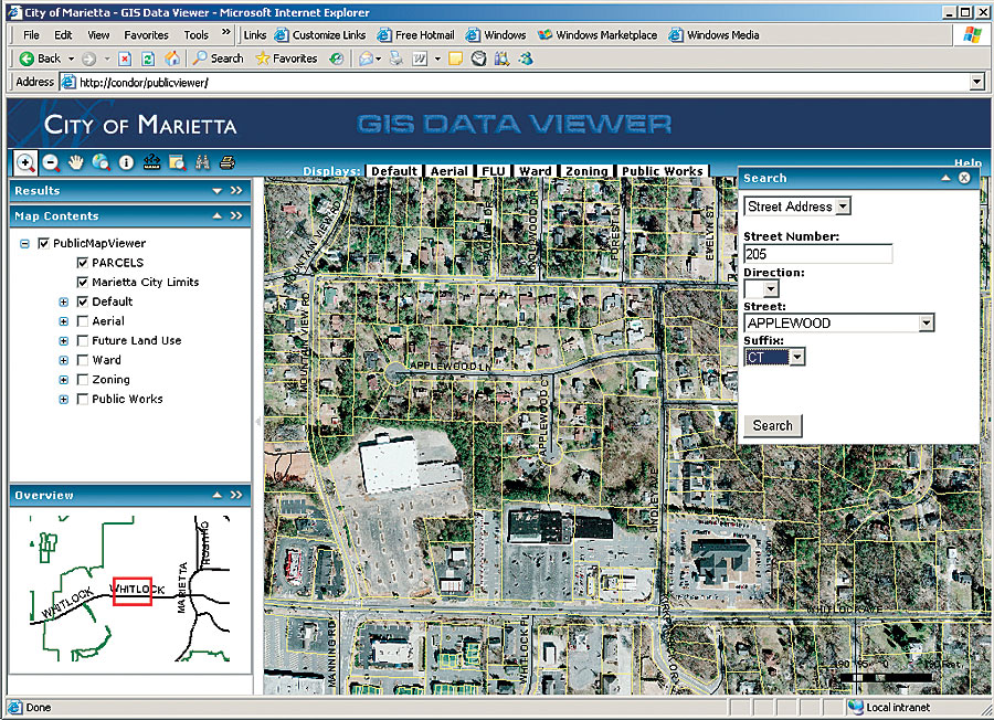
Many of Marietta's departments are equipped with GIS technology for process automation and business workflow efficiency, and it didn't take long for them to realize the power of ArcGIS Server. For years, Marietta's GIS Department used the same ArcView applications that had become ingrained in a couple of the city's departments. "Our attitude was, Why fix it if it isn't broken?" says Bruce Bishop, GIS manager for the City of Marietta. "After all, the ArcView environment was user-friendly; it offered a straightforward way to write custom scripts for automating workflows." Marietta had three custom ArcView modules (custom programmed tasks) that were operated by more than 30 users across multiple departments: Public Map Viewer, Code Enforcement, and Right-of-Way. From a user satisfaction standpoint, life was good, but maintaining these legacy applications and data became an increasing challenge. Clearly, a change was in order, so last year Bishop began attending Esri seminars and user group meetings on the 9.2 product line and ArcGIS Server. It didn't take Bishop long to see the possibilities, particularly the system's streamlining of viewing and editing distribution while at the same time centralizing data and application maintenance. "All I could think about was how much time we were spending maintaining our legacy ArcView application." After investigating the options, Bishop and the City of Marietta contracted services with Birmingham, Alabama, Esri Business Partner Geographic Information Services, Inc. (GISi), to develop an ArcGIS Server application. The city's central goal was simplified operation. Once the functionalities of the three legacy applications were consolidated into one centralized, server-based application called Public Map Viewer, time and money savings weren't far behind. Powered by Esri ArcGIS Server 9.2 technology, Public Map Viewer provides access to the city's geodatabase basemap data, such as aerial photography, parcels, street centerlines, edge of pavement, city limits, utilities, hydrology, wards, and zoning. At the core of the Public Map Viewer is the innovative Parcel Find tool, which allows users in the planning, code enforcement, permitting, and public works departments to search and locate a parcel or set of parcels in a number of ways, including street address, parcel ID, subdivision name, and street name. The city is also taking advantage of the geodatabase replication technology available at 9.2. A copy of the editing geodatabase is used for publication purposes, serving the Public Map Viewer on the Web. Internal users accessing the Public Map Viewer online are no longer at risk for impacting the editing database, and they're no longer affected by the stops and starts of day-to-day database maintenance. The replicated database can also serve as backup if needed. "The geodatabase replication technology that's available in version 9.2 facilitates the author, serve, and use model for GIS solutions," says Dan Levine, chief technology officer with GISi. "Esri's architecture very effectively supports the different roles of GIS users." When asked to list the top benefits the City of Marietta is receiving as a result of its switch to Esri's ArcGIS Server, Bishop didn't hesitate. "Without a doubt, we're saving time and money. From the day we went live with the Public Map Viewer solution, we've only needed to maintain one machine and one source of data. Having that time back has really added efficiency into our own department. Now, we're looking for even more ways to streamline workflows and automate processes." In addition to increased operating efficiency from ArcGIS Server, there's another major cost-saving benefit: Marietta no longer needs more than 30 ArcView licenses. Gone as well are the days of creating regular shapefile updates, then pushing application changes out to every desktop. Now, every bit of maintenance—from application to data—is done centrally on the server. It's created a whole new environment for a city that cherishes its unique past. Just as important, it's given the City of Marietta a powerful tool for the future. "Anytime you can reduce the time required for application and data maintenance by 25 percent and gain feature functionality in the process, it's a major milestone for an organization," says Bishop. More InformationFor more information, contact Bruce Bishop, GIS manager, City of Marietta, Georgia (e-mail: bbishop@mariettaga.gov), or Kevin Stewart, business development manager, GISi (e-mail: kstewart@gis-services.com). |