Fall 2007
Fall 2007 |
|||||||
|
|
|||||||
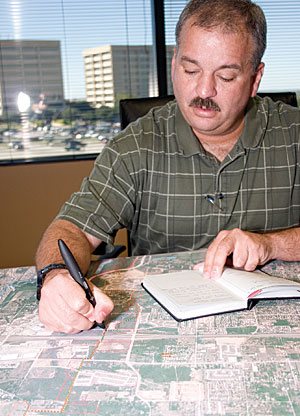
Field Engineers at Freese and Nichols Update the Geodatabase Digitally with Pen Strokes
Virtual Ink for GIS Facilitates Mobile Data Collection |
|||
Highlights
Writing things down is a powerful form of expression going back thousands of years. For field engineers accustomed to gathering around a paper map and making annotations thereon, bridging the gap between digital and tangible seemed a distant dream until recently. Last year, Freese and Nichols, Inc., a Texas-based engineering firm, integrated the use of virtual ink for GIS into its field operations and achieved significant time and cost savings as a result. In many cases, field staff at Freese and Nichols collaborate on a single map sheet on-site to develop the exact plan of action for a project. Although a common feature of mobile fieldwork, this "huddle-and-scrawl" method has its pitfalls. Essential data written on these paper maps often must wait to be entered into the geodatabase back at the office, introducing a critical time lag, as well as posing the risk of errors in the data entry process. In addition, the collaborative aspect of multiple-engineer data collection is all but lost as soon as the data gets back to the central database. Having recently been tapped to develop a 50-mile water pipeline route study, Freese and Nichols needed a more efficient solution for its mobile data collection practices. "We have a high volume of geospatial information that we must collect in the field for our projects," says Mark Valentino, GIS coordinator for Freese and Nichols. "Performing sketches on large paper maps and then manually transcribing the data back at the office was an inefficient means of updating the database." Freese and Nichols needed to eliminate the time lapse between when the data was collected and when it was entered into the central database; however, such a solution seemed like a tall order for even the most cutting-edge mobile data collection firms. The biggest hurdle seemed to be engineers' dependence on huddling around the paper map to decide what goes where. Was it possible to wean field staff from their use of paper and pen in the field? Given engineers' dependence on this tried-and-true method, the answer was a rather loud "no." Having done business with Esri Business Partner Adapx (pronounced "Adapts"), a Seattle, Washington-based mobile data collection firm, Freese and Nichols discovered the company was testing a data capture platform that had seamlessly combined GIS and virtual ink technology. Called Capturx for ArcGIS, the Adapx data capture system was just the cross-cutting solution that Freese and Nichols was looking for. Since GIS analysts at the engineering firm already used ArcGIS to design and maintain their geodatabase, they leaped at the chance to become early adopters of the technology. Here's how Capturx for ArcGIS works: Ordinary paper printed, or "watermarked," with a series of dots (called an Anoto pattern) allows the digital pen to determine its location on the map like coordinates on a globe. Together, the pen and paper can be used to specify the type of features to be captured, as well as attributes for those features. Each successive click of the pen records the items to be added to the digital version of the same map. When the pen is docked into the USB port on a PC or laptop, notes are immediately available and can be accessed with no additional assimilation work or gatekeeper involvement. Using ArcGIS, the field engineer can check out the latest GIS data, edit it on-site, and post changes back to the central database in an instant. "The pen converts handwritten forms, field journal notes, sketching, and comments on maps and satellite images into digital data," says Adapx CEO Ken Schneider. "Although it looks and feels like a regular ballpoint pen, it contains an integrated digital camera, an advanced image microprocessor, and a mobile communications device for wireless connection. As mobile staff write, the digital pen takes snapshots of their writing in conjunction with a printed pattern, capturing and processing everything that is written. This speeds turnaround time by fully integrating a business process that end users already know." Field engineers at Freese and Nichols are excited about the virtual ink solution, which has kept the collaborative environment intact while reducing the time and risk that traditional data entry involves. "With the Adapx solution, we don't change our practice of collecting data," says Valentino. "Data collection continues on-site and completely eliminates the reentering of information written and sketched on paper maps. It also preserves the collaboration of our engineers by distinguishing between the different users' digital pens once the digital ink is uploaded into ArcGIS." Adapx digital paper and pen technology reflects a growing trend in IT: the incorporation of multimodal interfaces into the workplace. Behind this school of thought is the bold idea that users needn't necessarily change; often, existing modalities, such as writing and speech, can be seamlessly adapted to proven systems. The successful integration of virtual ink technology into Freese and Nichols' mobile operations proves this to be true. More InformationFor more information about Freese and Nichols, contact Mark Valentino, GIS coordinator, Freese and Nichols, Inc. (e-mail: mrv@freese.com). For more information about Adapx, contact Scott Lind, vice president of Business Development (e-mail: scott.lind@adapx.com). To see a demonstration of Capturx for ArcGIS, visit www.adapx.com. |