Fall 2008
Fall 2008 |
|||||||
|
|
|||||||
U.S. DOT Provides Secure Access to the Nation's Pipeline Data with GIS |
|||
|
By Claiborne Ashby, NPMS Project Manager, Michael Baker Jr., Inc. Highlights
The U.S. Department of Transportation (DOT) Pipeline and Hazardous Materials Safety Administration (PHMSA) is charged with ensuring the reliable and safe transport of hazardous NPMS is a seamless geographic database (geodatabase) that contains data submitted by transmission pipeline, liquefied natural gas (LNG) plant, and breakout tank operators. Since the 2002 Pipeline Safety Improvement Act was passed, transmission pipeline and LNG plant operators have been required to submit their transmission pipeline and LNG plant location and attribute data to NPMS. Baker processes the data submissions and makes them available for federal, state, and local government agencies; pipeline operators; and, recently, the general public to view through the NPMS Web site (www.npms.phmsa.dot.gov). By providing secure online access to the data, PHMSA uses NPMS as a tool to support various regulatory programs, pipeline inspections, and authorized external customers. In 2001, Baker developed an ArcIMS Web site called the Pipeline Integrity Management Mapping Application (PIMMA) to share NPMS data with the general public. However, after the terrorist attacks of September 11, 2001, PHMSA conducted a data security review in conjunction with other federal agencies and decided to provide only limited public access to NPMS data. From September 2001 until April 2007, PIMMA had only been accessible to federal, state, and local government agencies and pipeline operators.
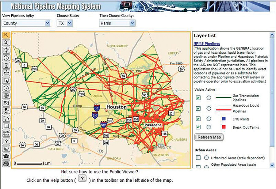
To strike a balance between data security and the public's right to know, PHMSA decided to make NPMS data available to the general public again, but with limitations. In April 2007, PHMSA and Baker released a new ArcIMS application called the NPMS Public Map Viewer. The application is designed to help the public understand which transmission pipelines exist in a user-selected county and to provide a means to contact pipeline operators to obtain additional information. The Public Map Viewer includes fewer background layers (for example, data on sole-source drinking water areas is omitted), but it includes much of the same functionality as PIMMA. Only one county's data is displayed per session, but the application can be relaunched to show another county's pipelines. The user may zoom in to a maximum map scale of 1:24,000, view information about the pipelines (including operator name, operator contact information, and commodity carried), and print maps. LNG plants and breakout tanks are also visible. Access to Sensitive MaterialUsers who would like PIMMA access must submit applications through the NPMS Web site. Once the applicants are screened, access is provided using a three-tiered geographic approach. Federal government officials are allowed access to the entire country; state and local government officials are allowed access to their areas of jurisdiction; and pipeline operators are allowed access to the pipelines they operate. PIMMA allows authenticated users to view pipeline, LNG, and breakout tank data as well as high-consequence areas (HCAs), which include sensitive ecological and drinking water areas. United States Geological Survey (USGS) topographic quadrangle maps and digital orthographic photos are available as background layers. Users can conduct preselected queries, such as searching by various data layer attributes and performing simple spatial analyses. Pipeline operators regularly submit integrity management plans to PHMSA, and with tools and queries in PIMMA, they can determine the segments of their pipelines that intersect HCAs. Those pipeline segments are then subject to special integrity management measures. PHMSA pipeline inspectors use PIMMA to view pipelines by operator, commodity, or geographic area and to schedule inspections. About the AuthorClaiborne Ashby is a GIS project manager at Michael Baker Jr., Inc., in Alexandria, Virginia. She served as the manager for NPMS from April 2006 to May 2008 and has recently handed over those responsibilities to Katie Field of Michael Baker Jr., Inc. More InformationFor more information, contact Claiborne Ashby, former NPMS project manager (e-mail: cashby@mbakercorp.com), or Katie Field, NPMS project manager (e-mail: KField@mbakercorp.com). |