Fall 2009
Fall 2009 |
|||||||
|
|
|||||||
California Selects GIS as One of the Six Key Enterprise IT Strategies |
|||
|
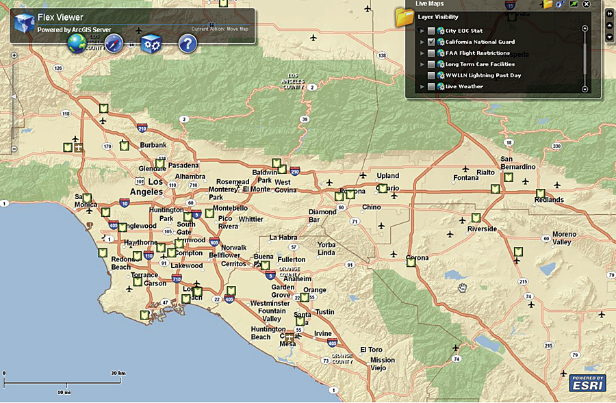
By Michael Byrne, Geospatial Information Officer, State of California California is the ninth largest economy in the world, the largest agricultural producer in the United States, one of the most biologically diverse places on the planet, and a leader in science and technology innovation. It is the nation's most populous state and is also home to floods, fires, and earthquakes. It covers more than 160,000 square miles and has temperate rainforests, deserts, mountains, and a spectacular coast. Recently, I was flying from San Diego in Southern California to San Jose (about halfway up the state) with a colleague from another state, and as we landed, he turned to me and said, "This is a big place." California is indeed a big place, and its state government similarly needs solutions fitting its size and range of issues. In February 2009, State Chief Information Officer (CIO) Teri Takai released the State Information Technology Capital Plan. This plan outlines the solutions the state will invest in over the coming years. The plan aligns these solutions along business-driven priorities, maps them across the state's IT strategic goals, and subsequently identifies opportunities for collaboration.
In the 2009 report, the CIO identified six of these opportunities: geographic information systems, business intelligence, transaction processing, enterprise content management, customer relationship management, and case management. What this effort really identifies is a set of unifying business examples that can be leveraged across agencies for increased economies of scale in technology service delivery. The fact that one of the technologies is GIS points to just how important GIS is as a solution for California needs. We need solutions that can tackle the large policy issues we face in this diverse state, and few technologies get us there—but GIS does. Of the 39 state departments identifying capital investments in information technology in this plan, 10 of them are projecting investment in GIS technologies. These departments are diverse. California Emergency Management Agency, Department of Forestry and Fire Protection, Department of Public Health, and State Water Resources Control Board are all planning on capital investments in GIS. The capital plan really gives the Office of the State Chief Information Officer the chance to analyze common business needs across departments and look for opportunities to align these investments. For instance, if we see a common thread of data, technology, or human resources need in these investments, we can allow partnerships to grow from these plans whereby infrastructure development or data can be shared. This collaborative approach allows us to save money, be more effective, and give the business units the best value gained. So where has California succeeded to date in this approach? Two projects in particular are notable. Both housed at the California Natural Resources Agency, the CalAtlas effort and the Common Operating Picture effort have been very successful by identifying common need for collaboration across agencies. CalAtlas (www.atlas.ca.gov) is the California central repository for geospatial data. CalAtlas embodies Web 2.0 technology and provides a framework for GIS data sharing. Users must first register. They then have the ability to catalog data they steward, push data for download at CalAtlas, develop services to be accessed, and publish basic maps. The real success of CalAtlas is that it is open and free to end users, which limits the need for duplicating publication infrastructure about spatial data in the state. Those agencies already with advanced infrastructures can use the services, as well as those with emerging GIS use. CalAtlas now has more than 11,000 registered datasets described and an estimated 200 terabytes of data to download. This data adds to the state's collective knowledge. The second effort, the Common Operating Picture (COP), was born out of the collaboration required during the response to the 2007 firestorm. During that event, literally thousands of wildland fires were raging in California at one time. Through partnerships with the California Department of Forestry and Fire Protection, the California Emergency Management Agency, the Natural Resources Agency, and Esri, the idea for the COP was born. The COP is a view of common geospatial data in California to be used for situational awareness. It contains common base, infrastructure, and critical asset type data, which is important for a common understanding of large-event response. Built on Esri Flex Viewer technology, the COP was tested during the Golden Guardian exercise of fall 2008. Golden Guardian is a test of the emergency response community, in partnership with U.S. Geological Survey (USGS) and others, usually held every other year in California. In 2008, the three-day exercise simulated a 7.8 earthquake along the San Andreas fault running from the Salton Sea to Los Angeles. During this exercise, many Emergency Operations Centers (EOCs) around the state used the COP to view the spatial data. This collaborative approach allows us to assess large problems with an economy of scale that is most effective. We don't plan on stopping there. The Office of the State Chief Information Officer has just released a comprehensive data strategy for the state. As an offshoot of one of the six strategic concepts (see www.itsp.ca.gov/Facing_the_Future/Strategic_Concepts/ default.asp), managing data as an asset is essential to more effective and efficient state government. The strategy identifies a common data approach to all data managed in state coffers. The data strategy identifies geographic data as core to nearly every data asset California owns. As such, developing a common, collaborative "data as a service" approach is essential to managing the scale of business and policy issues Californians face. This new strategy will lay the foundation for managing the spatial data component in all data and managing data as a service to benefit the most people. Pilot efforts for the data as a service approach are under way with Minimum Essential Datasets of imagery, roads, and landmarks. While Californians face significant budget challenges, they also expect the highest degree of innovation from technology solutions. GIS is a core solution that California will continue to build sophisticated business processes around to increase government effectiveness. About the AuthorMichael Byrne, M.A., GISP, is the geospatial information officer for the State of California. He has 18 years of GIS experience in a wide variety of positions in California state government and academia. He has served as a GIS manager for the University of California, Davis's Information Center for the Environment, and as staff to the Secretary for Resources implementing special GIS projects. Byrne is a member of the National Geospatial Advisory Committee and a director for both the National States Geographic Information Council and GreenInfo. He holds a bachelor of science in environmental planning and a master of arts in geography, both from the University of California, Davis. More InformationFor more information, contact Michael Byrne (e-mail: michael.byrne@cio.ca.gov). |