Fall 2009
Fall 2009 |
|||||||
|
|
|||||||
Geoservices Create a Framework for Collaboration, Understanding, and Open Government
GIS Professionals Lead the GeoWeb Revolution |
|||
|
The adage "The Web changes everything" can be applied to many things, and GIS is no exception. Over the last several years, many people have made predictions about Web mapping somehow making professional GIS less relevant. But we at Esri see something very different. We see the geospatially enabled Web—the GeoWeb—driving change that is beneficial for both users and creators of geospatial information.
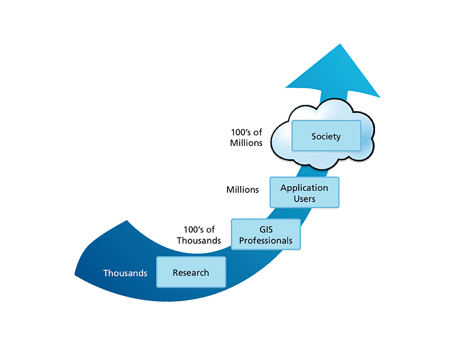
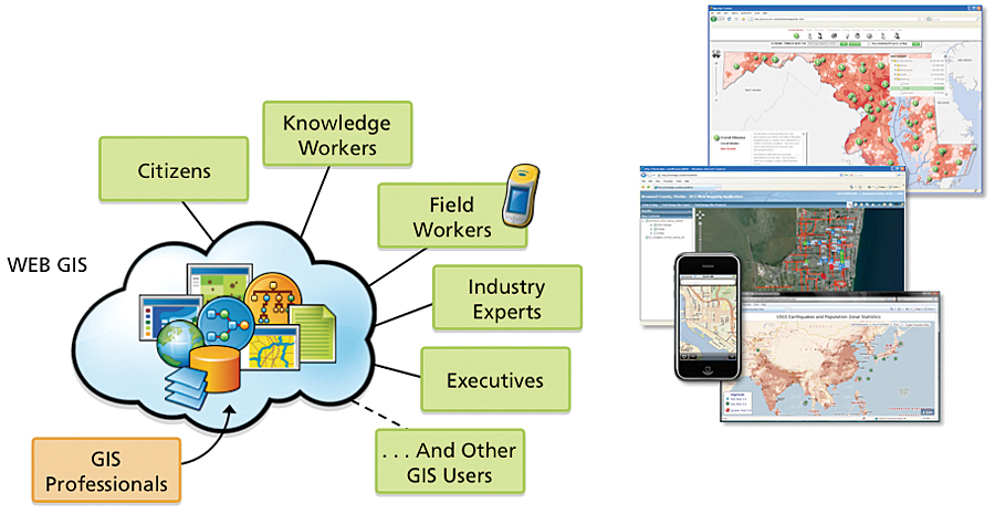
Geographic knowledge created in GIS environments is increasingly being made available to Web users, and consumer and commercial awareness of geospatial capabilities has grown tremendously. The geospatial industry has never before had this much attention focused on it. This is leading to open, more transparent access to geographic knowledge and increasing the value of you, the GIS professionals responsible for creating the majority of the world's geographic knowledge. What Is Geographic Knowledge?Geographic knowledge is an assemblage of data describing spatial phenomena; data models that structure the data; models and analytic tools that show predictions or suitability; cartographic expression; geospatial workflows; and metadata, which describes the first five components and is key to sharing, discovery, and access. The current state of geographic knowledge has changed how we abstract our world and how we reason. People are thinking more about relationships between things and interconnections. The good work of Google, Microsoft, and others, in creating a more spatially aware society has consequences beyond simply looking at maps. The GeoWeb is a revolution in spatially integrated thinking. Geographic knowledge can be created by specialists from many fields, across government, academia, and business, often brought together by GIS professionals who focus on broad issues such as integration and access. Having the technical skills needed to perform geocentric operations that support mission-critical applications leads to a better understanding of complex issues and more holistic decision making. Sharing geographic knowledge in the GeoWeb environment is also changing how we organize and communicate between different agencies and organizations. And this is just the beginning. The GeoWeb revolution will go far beyond simple visualization and mapping, embracing all types of knowledge and ultimately becoming a societal infrastructure for human behavior and human action. The Next WaveFrom the beginning, GIS has been focused on capturing, creating, applying, and sharing geographic knowledge, regardless of the platform. From mainframes to minicomputers, UNIX workstations to desktop PCs, and mobile devices to massive servers, GIS is a pervasive technology that adapts well to and even thrives on the next platform. And today, the Web is the next platform. But in some ways the migration to the GeoWeb is different from platform migrations we've experienced in the past. Opening large GIS databases for much wider access is something that we at Esri have been striving to achieve for many years. And now this dream is finally being realized on the GeoWeb. Users of GIS technology in government and elsewhere have made enormous contributions to the GeoWeb in terms of basemaps, thematic datasets, and more. What really drives GIS users is integration of this geographic knowledge into human action. Using geographic knowledge impacts business and government and helps create a more sustainable world, and its pervasive use enables unprecedented levels of transparency and decision making. This is the real impact of the GeoWeb. From Data Sharing to GeoservicesToday, geographic knowledge is a valuable commodity, especially in government. Geographic knowledge is used successfully in a multitude of applications and provides a critical infrastructure to improve planning, management, and decision making. Data sharing has been key to this success—many government agencies consider sharing to be a key component of their mission, and data clearinghouses have greatly improved access—but these efforts have not resulted in a true geospatial framework. To realize such a framework, we need to move beyond sharing of GIS databases and into an era of shared geoservices. GIS professionals in government will play a large role in creating these shared services, and GIS professionals everywhere will leverage these geoservices to open up access to geographic knowledge to large numbers of new users through new types of applications, providing authoritative data, high-quality maps, visualizations, spatial analysis, and models to new audiences. The GeoWeb makes geographic knowledge more accessible to people who are not trained in geography or GIS, but who still have much to benefit. In this next wave, GIS professionals will increasingly be called on to create this geographic knowledge and set the context for its use. We already see this happening today. Sharing Geographic KnowledgeThe fundamental difference between the Web platform and the other platforms that GIS has historically embraced is that the Web is transforming access to the global geographic knowledge base, taking what were dispersed bits of knowledge and making them more available, usable, and collaborative. And the GIS user community is leading this movement by transforming its datasets into services so those published services can be mashed up with other Web services and made available for new audiences.
Sharing of geographic knowledge on the GeoWeb is enabled by a new breed of geoservers. These servers are easy to use, standards based, collaborative, and key to leveraging the billions of dollars already invested by the GIS community in developing basemaps, thematic datasets, and other geographic knowledge. One particularly interesting aspect of sharing geographic knowledge on the GeoWeb involves user-generated content (UGC)/volunteered geographic information (VGI). There can be major differences between the authoritative content developed in a professional GIS workflow and the casual content volunteered by people on the GeoWeb. Both types of information can be valuable, but we need to remember that certain types of decisions need to be made from verified, authoritative content to ensure reliability and accuracy of the decision. GIS Professionals Are More Relevant Than EverGeography and GIS bring together information from many different fields and sciences—physical, social, cultural, and design—and integrate the resulting geographic knowledge across disciplines through mapping and modeling of spatial relationships and patterns. Geographers and GIS professionals then apply this knowledge across government and industry. GIS is an integrative platform that brings information together and facilitates coordination and cooperation across organizations and disciplines. The result is a new approach to problem solving: The Geographic Approach. The Geographic Approach can be characterized as quantitative, systematic, analytic, and representative of integrated thinking. GIS professionals provide the skills and understanding to apply this approach in ways that are responsive to the needs of their organizations. Demand for these talents is increasing rapidly because most people trained in domain-specific disciplines do not have the same level of exposure to multidisciplinary problem solving and integrative thinking as geography and GIS professionals. Today's GeoWeb environment gives GIS professionals many opportunities to share their geographic knowledge. The Web is helping expand the relevance of GIS and make it more pervasive, and GIS professionals are the people already creating and managing this infrastructure. This offers many new opportunities and challenges—building new partnerships, learning how to collaborate, sharing information, etc. In this sense, GIS is just beginning. GIS Technology Is EvolvingThe popularity of Web-based mapping has increased the awareness and value of what GIS professionals do. This, together with the advances in Esri's Web mapping technology, makes the GeoWeb a window into the wide-ranging collection of geographic knowledge authored by the GIS community. The GeoWeb is also changing user expectations. The definition of a good map has evolved, from paper-based and digital maps to intuitive and interactive maps served on the Web. With traditional GIS maps, the emphasis has been on the information and analysis behind the map. Now with the GeoWeb, the map itself is increasingly the focus of attention; it is a rich, stand-alone information product that must be designed carefully for end users. Even within complex government organizations with vast collections of geographic knowledge, only a limited number of these information products are needed. These organizations have standard cartographic symbols and layouts that are used to support various workflows. It can also be said that whole classes of organizations (cities, for example) share the similar workflows with respect to their need for standard map products. This has led to an effort to design and share a series of common templates for mapping with desktop GIS and the GeoWeb. (See resources.arcgis.com/content/maptemplates/about.) The Technology Exists to Do This NowEsri has been aggressively designing products to effectively leverage the Web 2.0 environment. The centerpiece of this effort is ArcGIS Server, the first full Web 2.0 GIS platform. ArcGIS Server supports fast, high-quality mapping; globe services; and powerful geoprocessing services. ArcGIS Server also provides easy-to-use, consumer-style mapping with a variety of REST-based Web APIs (Flex, JavaScript, and Microsoft Silverlight) as well as capabilities that promote sharing of geographic knowledge and collaboration between and among users. ArcGIS services can also be easily mashed up with other Web services to support development of cutting-edge applications. Other technologies in Esri's Web 2.0 strategy include ArcGIS Explorer, a powerful, free GIS viewer, and ArcGIS Online, which provides content and sharing capabilities for GIS users to leverage. Success Is GrowingMany successful GeoWeb applications have already been deployed, and many more are emerging. The applications are richer, more dynamic, and more collaborative. We are seeing new styles, patterns, and techniques emerging, helping to disseminate geographic knowledge and the concepts of geography to ever-widening groups of users. The GeoWeb promises to explode geospatial applications and the usefulness of geographic knowledge. Leveraging the large investments already made by government and others, serving geographic knowledge will better connect government and citizens, encourage more collaboration, and ultimately realize a more open form of government. We believe the evolution of the GeoWeb is just beginning, and it is becoming a strong multiparticipant framework. But with all this emphasis on geoservers and the GeoWeb, desktop GIS will continue to grow as the solution for most spatial analysis projects and the fundamental authoring platform for creating the majority of the geographic knowledge consumed on the GeoWeb. ConclusionThe Web environment is a fantastic visualization and content-delivery platform for information about the world we live in. As people become more familiar with visualization tools and their voracious appetite for geographic knowledge increases, they are beginning to ask more intelligent questions about the world, and the work being done by GIS professionals in creating geographic knowledge has never been more important or appreciated. The GeoWeb revolution will have lasting repercussions well beyond the GeoWeb itself. As geographic knowledge becomes embedded in every device and changes our way of thinking, it presents an opportunity for GIS professionals to expand geospatial literacy toward sophisticated analysis and spatial decision making. |