Fall 2009
Fall 2009 |
|||||||
|
|
|||||||
Governance of the NSDI |
|
|
By Will Craig, President of the National States Geographic Information Council
It was a wonderful concept—liberating and energizing—but we have gotten much less than I was hoping for over the past 15 years. There are only a few success stories. As I see the problem, we simply have not organized ourselves very effectively. This article describes the current geospatial governance structure in the United States, discusses current problems, looks at state models for success, and makes recommendations for doing things differently at the national level. Through a directive from the Office of Management and Budget (OMB), we have put significant effort into identifying key data elements in that infrastructure and assigning responsibilities to develop and maintain that data. The Federal Geographic Data Committee (FGDC) is charged with coordinating those efforts but does not have the power to make or enforce rules. Federal agencies continue to create "stovepipes of excellence" and cooperate only when desirable to themselves, very rarely because of outside pressure. Equally important, the NSDI has a federal focus and often does not meet the needs of state or local government—let alone the private sector or public. State governments have done a better job of coordinating their state spatial data infrastructures. Ironically, they have gotten funding from FGDC to develop the strategic and business plans necessary to make the transition. Many states have geographic information officers (GIOs) to coordinate state-level activities and advisory councils composed of other stakeholders to help coordinate the activities of municipal, county, and tribal governments. A similar approach should be used at the federal and national level to create the governance structure that will allow us to finally reach the full potential of the NSDI. Cracks in the system are becoming apparent to Congress. In June 2009, the Congressional Research Service published a report called Geospatial Information and Geographic Information Systems (GIS): Current Issues and Future Challenges. The report tries to address the questions of "how effectively [is] the FGDC . . . fulfilling its mission" and "how well is the federal government coordinating with the state and local entities" (see www.fas.org/sgp/crs/misc/R40625.pdf). On July 23, 2009, the Energy and Mineral Resources Subcommittee of the House Natural Resources Committee held an oversight hearing on federal geospatial data management. Rep. John Sarbanes of Maryland quoted a U.S. General Accounting Office (GAO) report from his briefing material saying that only 4 of the 17 [sic] FGDC member agencies were in compliance. A video of that hearing and written testimony of witnesses is online at resourcescommittee.house.gov/ index.php?option=com_jcalpro&Itemid=27&extmode=view&extid=278. Most of the discussion in the hearing was about eliminating redundant data collection. Not much was about filling gaps. OMB, FGDC, and NSDIThe current federal geographic governance structure has a long history. In 1953, the federal executive OMB issued Circular A-16. Originally aimed at federal surveying and mapping activities, that circular has been revised several times and is now titled Coordination of Geographic Information and Related Spatial Data Activities. Circular A-16 is the basis for all federal geospatial data coordination efforts. OMB is a cabinet-level office, monitoring the performance of the various federal agencies that report to the president, guiding them when they stray, and making recommendations for future presidential budgets. This is a powerful office, but it has tended to delegate geospatial data coordination to FGDC. FGDC was created in the 1990 revision to OMB Circular A-16. This is when the circular began looking at spatial data use and coordination across federal agencies. The committee consists of leaders from 30 federal agencies—up from 18 listed in the 2002 revision of Circular A-16. It is chaired by the secretary of the interior. The strength of the committee is determined by the strength of personalities running it, and that strength has varied over the years. Not all member agencies are fully committed, as indicated at the oversight hearing. When the NSDI was created in 1994 by President Clinton's Executive Order 12906, its purpose was to "support public and private applications of geospatial data in such areas as transportation, community development, agriculture, emergency response, environmental management, and information technology." Responsibility for implementation was given to FGDC. With minor modifications to provide a special role for the new Department of Homeland Security, President George W. Bush continued the NSDI in his Executive Order 13286 in 2003. There were weaknesses in all this. One of the things that went wrong fairly early was a fixation on framework data. These were the seven data layers that were seen as first steps toward fulfilling the vision of the NSDI: geodetic control, orthoimagery, elevation and bathymetry, transportation, hydrography, cadastral, and governmental units. Circular A-16 describes these as the seven "themes of geospatial data that are used by most GIS applications." In fact, I most frequently use land-use and soil data for my environmental work and socioeconomic data for my urban planning work. But, these seven were seen both as easy first steps and as a solid frame to which other data could be referenced. To be sure, Circular A-16 lists some 34 data categories and assigns each to a federal agency, but few agencies are working on their assignments. Land use is not in the list of data categories—along with many other elements that we all find useful in our daily work. It turned out that framework data was not so easy to complete or coordinate. The National Academy of Sciences points out that the Federal Emergency Management Agency (FEMA) needs land surface elevation data that is about 10 times more accurate than data currently available (2007) for most of the nation. The transportation layer is maintained in various forms by agencies including the U.S. Census Bureau and Department of Transportation, the latter having several different versions. The cadastral layer effort soon abandoned securing data on all private landownership and even smaller federal land holdings, leaving only large federal holdings, like Yellowstone National Park, and Public Land Survey corners. One of the best success stories is GPS, something that was not seen as part of the NSDI. This technology was developed by a federal agency (the U.S. military), but kept relatively secret with only degraded access to it until 2000 when President Clinton opened the door for public access. Today, GPS is a multibillion-dollar industry with devices on the dashboards of cars, in cell phones, and even on dog collars. This happened within a single agency and outside our national data governance structure. We knew early on that data could not be developed without a partnership between the federal government on the one hand and state, local, and tribal governments on the other. Those relationships were required in Clinton's NSDI executive order. They were underscored in a series of reports from the National Academy of Sciences. The first of these was Toward a Coordinated Spatial Data Infrastructure for the Nation, which predated Clinton's executive order and set the stage for it. Perhaps the most relevant today is the 2003 report, Weaving a National Map: Review of the U.S. Geological Survey Concept of The National Map, that envisioned a national quilt of high-resolution local data that could be rewoven into a national blanket of uniform quality. Data for the NationThe National States Geographic Information Council (NSGIC) and others are starting to use the phrase for the nation. Imagery for the Nation (IFTN), Transportation for the Nation (TFTN), and Elevation for the Nation are examples of this new approach in labeling. To NSGIC, this term means something quite specific: data is available nationwide, it has sufficient spatial and topical resolution to meet the needs of all levels of government, and resources are available to keep the data current. The processes for conceiving, developing, and maintaining such data are described with 20 discrete criteria on the NSGIC Web site. Only a few data themes exist that meet these criteria. There are four ways to produce data that meets the needs of all levels of government. The traditional way is for federal programs to deliver data at sufficiently fine resolution to meet everyone's needs. A good example of such a program is the Soil Survey Geographic Database (SSURGO) county soils maps provided by the Natural Resources Conservation Service; these maps provide sufficient detail for state and local applications, though not for individual farmers who want to manage their fields intensively. Also, the Census Bureau provides population and housing data at the block level and above—again, sufficient for all but the most detailed local needs. The National Wetland Inventory and the National Hydrography Dataset also fall into this category. Not many other examples exist. I call these "happy accidents." They almost always involve a federal partnership with state or local government, but those partnerships are matters of convenience and not the result of our governance structure. A second way to meet the needs of all levels of government is through federal programs that allow state and local governments to participate through buy-up options. The IFTN program, proposed by NSGIC, starts with the U.S. Department of Agriculture's (USDA) 1-meter National Agricultural Imagery Program and allows locals to add sensors (e.g., four-band) and expanded coverage into nonagricultural areas. IFTN also provides for the business needs of local government with a higher-resolution 1-foot program that would be administered by the United States Geological Survey (USGS). This component also has buy-up options that include 6-inch resolution, true orthophotographs; increased horizontal accuracies; and other features important to local government. Ideally, states would coordinate the many local requirements and funding, making it easier for USDA, USGS, and their contractors to meet local needs. A third way to meet the needs of all levels of government is for local government to collect data that meets its needs, with state and federal governments rolling this data up to summary levels sufficient for their more general needs. This is actually fairly rare, but I have a good example from McLeod County in central Minnesota. The county wanted 1-foot contour data and worked with several local cities and a watershed district to contract for services. USGS needed only 10-foot resolution for its National Elevation Database, but contributed financially so it could access the finer data, process it, and publish a 10-foot summary of the original county data. The Minnesota Department of Transportation also contributed to the effort. This partnership was recognized in 2008 with a commendation from the governor of the state of Minnesota. A fourth approach is for the private sector to get involved and create something that has value to the nation—enough value to support the enterprise. A number of popular Web providers of maps, travel directions, and aerial photos are doing a great job of delivering this kind of information to the public; much of the data comes from government sources, but it is delivered in useful packages by private firms. Ideally, we would base other work on public/private partnerships, so government has a say in the nature and availability of the final product. We lack good models on how this should work, but the potential is there. Parcels and AddressesParcels and addresses are especially useful pieces of the NSDI from my perspective. They present a conundrum for federal partnerships. Many federal agencies need such data for their day-to-day operations or in emergencies. This data is typically created and maintained by local government, but there is no systematic way for this local data to flow up to state or federal agencies as described in the third option above for delivering data for the nation. There is no system for collecting and organizing local data, so federal agencies collect their own data. Taxpayers foot the bill for multiple versions of the same data. No governing body in Washington has responsibility for resolving the conundrum—addressing the fragmented landscape. Data on addresses is the most vexing because it is the closest to being ready for widespread sharing. The Census Bureau and the U.S. Postal Service have nationwide databases but share only with each other. A 1982 Supreme Court decision supports the Census Bureau decision to not share its Master Address File with local government. That decision was based on the court's understanding of congressional intent in writing Title 13 of the U.S. Code forbidding access to internal Census Bureau records, not on any intrinsic right of privacy. The past 27 years have brought significant developments in technology and business databases, making moot decisions about unknown addresses. Most recently, the Census Bureau has spent millions of dollars hiring out GPS work to add an x,y coordinate to every front door in America. For some reason, this information is also held as nonpublic. I could easily see a system where I provide my address to the Census Bureau and it returns my x,y coordinate. Local governments and 911 authorities would love to have this information for their business needs but do not have the funds to collect this data themselves and cannot get it from the Census Bureau. I am not talking about internal and possibly illegal housing units, just about the front door that anyone could see when walking by. I am not talking about unknown places in the woods, only those buildings for which the local authority already has addresses. The x,y coordinates remain an internal, nonpublic resource at the Census Bureau, paid for with public funds, but not available to the public or any other government agency. Does this make sense?
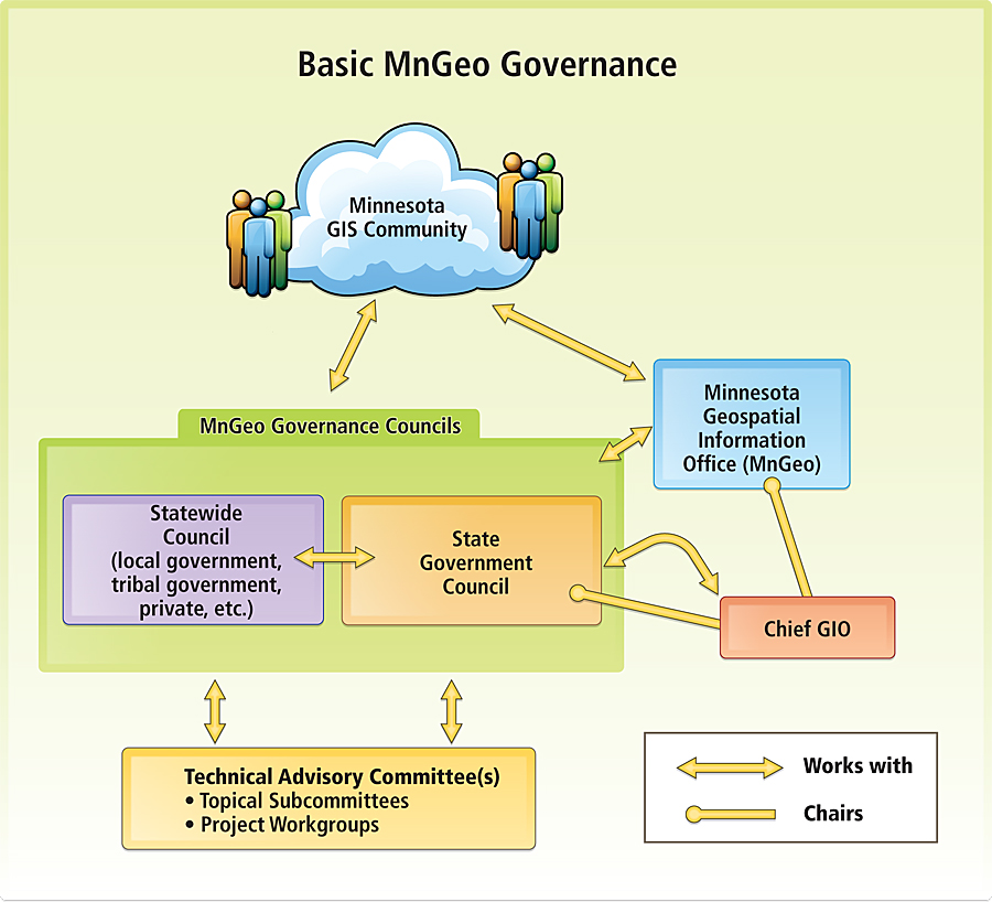
Parcels are in a similar situation, but different because no federal agency has responsibility for maintaining a national parcel dataset. Nearly every domestic agency, save USGS, has the need for parcel data. USDA needs parcel data to manage its crop insurance programs. Our national parks and forests need information on parcels to communicate with neighboring landowners. FEMA needs parcel data for rescue and recovery operations; it wasted millions of dollars following Hurricane Katrina in aid to people who did not own property in the damaged area. The Census Bureau could use parcels on the outer edge of cities to update their governmental unit boundaries. The U.S. Department of Housing and Urban Development (HUD) could use parcel data to monitor urban decay or renaissance. Some would argue that access to good parcel data would have allowed us to foresee the recent mortgage crisis and intervene before things went so horribly wrong. A 2007 report by the National Academy of Sciences looked at parcel data issues: National Land Parcel Data: A Vision for the Future. I was on the committee that drafted that report. We envisioned a Web mapping service that would allow people to see parcel maps, along with a limited set of attributes, for any place in the country without regard to county or state borders. States would play an intermediary role, adding their own landownership data and managing records for those local governments without sufficient internal capacity. This is technically and economically feasible. Yet the United States cannot do it because we lack the will and a governance structure to develop and manage such a system. The first recommendation of our study was to create a panel to identify a national coordinator to begin working on the governance issue. The Bureau of Land Management (BLM) has responsibility for the cadastre under OMB Circular A-16, so the panel would start by determining whether BLM has enough authority and capacity to do the job. Two years after our report was published, there is still no panel looking at this issue. States Are OrganizedStates around the country coordinate GIS activities better than the federal government. They typically have some kind of statewide council. The most effective councils coordinate activities at the state level with a strong hand but work gently with local governments. They include representatives from all stakeholder groups, including federal, state, county, municipal, and tribal governments; private-sector GIS users and providers; the academic sector; nonprofit organizations; utilities; and the general public. They have clear vision, supported by a strategic plan and a business plan. The Fifty States Initiative was designed by NSGIC and FGDC to help states become effective coordinators. This initiative is intended to connect with the data resources of the 50 states and, through them, to the 3,141 counties, over 18,000 municipalities, and more than 370 tribal governments. To this end, FGDC has funded 46 states in developing strategic and/or business plans to support the NSDI. NSGIC has developed a scorecard so each state can know how it stands on relevant criteria. The scorecard has nine criteria starting with a full-time coordinator and sustainable funding. More powerful criteria include a clearly defined authority for state-level coordination, the ability to coordinate with local government and other stakeholders, and a formal relationship with the state chief information officer (CIO). My own state recently created the Minnesota Geographic Information Office (MnGeo). The state had been struggling with fragmented operations, and its NSGIC scorecard showed it. With a grant from FGDC, it hired a private firm to help bring together stakeholders and develop a governance model that would work (see diagram above). The plan called for the new MnGeo with two advisory bodies: one for state government coordination and one for statewide coordination. The state government advisory council is composed entirely of state agency GIS representatives. The statewide advisory council is composed of representatives of local government, the private sector, tribal government, nonprofit organizations, and academia. The GIO participates on both committees—as the chair of the state government council and as a nonvoting member of the statewide council.
The National SolutionThe simple solution is to "get organized," along the lines of what the states are doing. There are no technical problems in developing the NSDI, only organizational ones. Increased governance is necessary to make things work better. I see four parts to this new model: (1) creation of a new federal Geographic Information Office, (2) a radical empowerment of FGDC to coordinate federal GIS activities, (3) the creation of a new body representing nonfederal stakeholders, and (4) development of a congressional oversight committee to watch and guide overall activities. At the federal level, we need a structure that supports and demands coordination of geospatial data development across federal agencies. This should start with the creation of a new position—a federal GIO. The office should be part of the Office of Management and Budget. OMB develops and executes a government-wide management agenda and assists the president in preparing his budget. It already houses the new federal CIO. This is the ideal place to set federal mandates for agency operations. One of the first tasks of the new GIO should be to develop an economic argument for the NSDI. NSGIC has estimated the price of the NSDI at nearly $9 billion, with an annualized cost of about $2.5 billion. Is it worth it? If so, where are the highest payoffs? The effort should begin by defining a rigorous methodology that delivers results understandable to both economists and the educated public, including agency heads and members of Congress. The study should cover all levels of government, the private sector, and the public. NSGIC has suggested that the economic study should be delivered within 18 months after the GIO takes office. If the study shows positive benefits, support for the NSDI will logically follow. FGDC should continue to coordinate activities at the federal level, but with more muscle behind its efforts. Duplicative activities should be identified and corrected. Agencies should be held accountable for fulfilling data assignments. Gaps should be identified, prioritized on economic return, and assigned to agencies. To operate effectively, FGDC probably needs to be moved from its current home in the Department of the Interior to OMB, since that organization has the mandate to review the performance of federal agencies and make budget recommendations affecting them. Over time, I have written two contradictory articles about what it takes to make a difference in the world of sharing data. In 1995, I wrote about institutional inertia and the need for a body outside the organization, usually the chief executive or legislative body, to set the rules for organizational mandates and individual rewards. Later, in 2005, I recanted, as I recognized the value of "white knights" who are motivated to do what is right regardless of the institutional rules. I think I was right the first time—at least for something as large and complex as the NSDI. Certainly, large federal agencies need that outside oversight. A National Spatial Data Council (NSDC) is needed to coordinate nonfederal activities. This idea has been around for years. I took this name from a 1998 report of the National Academy of Public Administration, Geographic Information for the 21st Century. The NSDC, or whatever we decide to call it, should be composed of stakeholder representatives from state, local, and tribal governments; the private sector; academia; and others. The representation should look much like that of the current National Geospatial Advisory Committee to FGDC, but would have power, grant-making ability, and access to the GIO. The federal government should be represented by FGDC as a nonvoting member. A new congressional oversight committee could do three things: set the expectations for federal agencies and the new NSDC; monitor performance, asking hard questions; and become the political champion to support the development and maintenance of the NSDI. As a nation, we have gone nearly two decades with limited progress on the NSDI. Most of that progress has been made through the goodwill and volunteer efforts of altruistic people and organizations. We are in the information age, but we're still building stovepipes. It's time to put some muscle and money behind the NSDI vision. About the AuthorWill Craig is associate director of the Center for Urban & Regional Affairs at the University of Minnesota. He chaired URISA's Research Agenda Group in the mid-1980s, proposing an agenda that had a strong focus on institutional research. He is the president of NSGIC and has been inducted into URISA's GIS Hall of Fame. More InformationFor more information, contact Will Craig (e-mail: wcraig@umn.edu). |
 The concept of the National Spatial Data Infrastructure (NSDI) has been around since the early 1990s, and the name has been in existence since 1994, when President Bill Clinton used it to label his executive order creating it. The name sounded strange when I first heard it; why infrastructure? Then I realized that data is infrastructure. Everybody else got it too. It was the first time the United States began to see data as infrastructure—equivalent to concrete roadways and metal pipes. This was the new information age, and data was the basis for economic growth and environmental integrity.