Fall 2009
Fall 2009 |
|||||||
|
|
|||||||
Small Island SDI Is a Huge Success
Remote Communities Prevail with GIS |
|||||||||
Highlights
GIS for spatial data infrastructure (SDI) is used throughout the world to instill cooperation and collaboration in sharing spatial data to better address social, economic, and environmental issues. It seems logical that large countries like the United States have invested in SDI, such as the Geospatial One-Stop, and national unions, such as the European Union, have come together to share data and resources via the Infrastructure for Spatial Information in Europe (INSPIRE). Does SDI make sense for smaller countries and communities? Arguably, even smaller nations benefit from land being carefully mapped, public works and utilities documented, environments and biodiversity protected, and resources assessed and strategic planning completed.
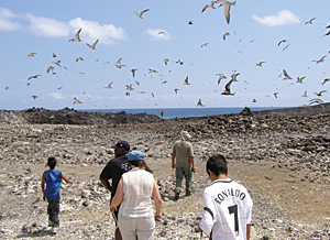
Thanks to special funding through the joint United Kingdom Foreign Office/Department for International Development Environment Programme, a group of UK overseas territories and the member states of the Organization of Eastern Caribbean States are able to rely on GIS for SDI, using the solution for data quality and control, information sharing, and delivering finished products for use between governmental agencies and private organizations. Calling themselves "tiny SDI," these small islands use ArcGIS as the backbone for spatial data sharing. Most islands were using Esri GIS software products in some form or fashion before SDI was implemented. As Alan Mills, principal with Alan Mills Consulting, Ltd., and one of the thinkers behind using SDI to help manage smaller islands, explains it, "We realized there was synergy in sharing the same add-on applications developed with GIS across the islands. Along with the backup support from other islands doing the same functions, the GIS managers on these remote places would feel a sense of community and have a place to go when they needed help. This is important when you live on a small island in the middle of the ocean three days' boat ride from the nearest airport, and you have to be the expert in GPS, databases, cartography, digitizing, and changing the ink in the plotter. Many of these projects produce baby steps in making SDI, but these smaller islands should not be excluded from making best use of GIS for their own special purposes." Ascension Island Discovers Data SharingOne island that has many unique needs housed in a small space is UK overseas territory Ascension Island, situated in the sea halfway between Africa and Brazil. Only 34 square miles in area (approximately 88 square kilometers), the island is inhabited by about 1,000 people. Because the island is a relatively recent volcanic emergence close to the Mid-Atlantic Ridge, there is little natural vegetation except for a few species of ferns and spurge, a plant that exudes a bitter milky juice. The island became a refuge for a wide variety of marine species and is the second largest Atlantic nesting site for green turtles. Humans discovered the island in the 1500s, and since that time, the island's ecology has changed significantly: invasive plant species have run rampant over parts of the island and rats and cats have decimated the bird populations. Bird and turtle populations have oceanwide impact on biodiversity, and the Conservation Department established by the small Ascension Island government is mandated to protect and enhance the crucial nesting sites, as well as conserve the local plants, crabs, and invertebrates. Since 2005, GIS has been used to synthesize disparate databases and datasets and create new maps and images for environmental management. GIS also assists with other applications, including the Environmental Health Department's rat control mapping, and documenting of an eclectic set of historical sites, such as the guns of the sunken HMS Hood, Dampier's Drip (the original freshwater source for the island), and concrete water catchments in the mountainside that collect scarce cloud water for the island's predesalination plant. Using ArcView, a component of ArcGIS Desktop, the system works well. Says Dr. Edsel Daniel, professor, Vanderbilt University in Nashville, Tennessee, a codeveloper of the SDIs for Ascension and St. Helena, and a colleague of Mills, "The software is easy enough to be handled by nonexperts. We are able to use a flexible framework that accepts new monitoring data and can integrate datasets from a wide variety of sources and types." ArcView integrates all the data necessary for the government to make informed planning decisions to balance environmental, amenity, and infrastructural priorities. Clear protocols and procedures have been determined to pass data from the field to the end user. "The key to this system to function in such a small area so economically with great benefit is the fact that data gathered for one purpose can be shared in many applications," asserts Mills. St. Helena Finds Cooperation Is the Key
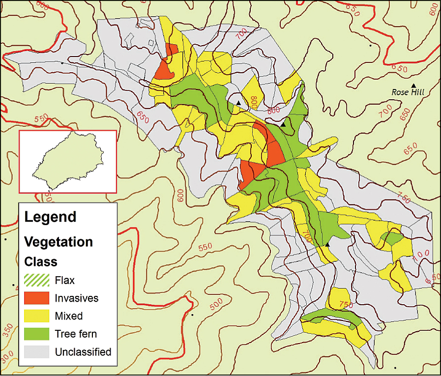
St. Helena, about 750 miles (1,207 kilometers) southeast of Ascension, cannot be reached by air. Instead, a visitor must take the RMS St. Helena, which plows between Cape Town, South Africa; St. Helena; and Ascension each month. Approximately 3,500 hardy settlers live on the island, many above the precipitous cliffs or in a narrow canyon where the well-preserved Georgian capital of Jamestown nestles, near landscapes of rocky desert, rolling pastures, and eucalyptus and pine plantations. Near the coast, humpback whale mothers and calves shelter themselves, and thousands of seabirds cling to cliff edges and stacks. At first, GIS was used to determine the best locations to place freshwater boreholes. In 2004, other projects began, the largest being building the island's cadastre. The St. Helena Agriculture and Natural Resources Department (ANRD), along with the St. Helena National Trust, implemented ArcView and a Microsoft Access database to monitor clearance of invasive flax and other plants and manage the growth of endemic cabbage trees and tree ferns. Len Coleman, GIS manager, St. Helena, says, "The emergence of a map showing the recolonization of endemics over a 10-year period gave other departments the idea to link their monitoring data with the mapping being accomplished." A single system was then designed to minimize duplication of effort and share the burden of data collection and management. The St. Helena Legal, Lands, and Planning Department was keen on expanding its new cadastral GIS and database, and working with ANRD meant environmental concerns were known by the planning unit for both strategic plans and the development control process. Sharing resources also makes it easier for training sessions to be organized and held for occasional users of GIS. Data is not duplicated, and there is better quality control and attribution when it is used for multiple applications. Visiting scientists and consultants can search the data catalog and have a recognizable way of contributing information back to the system in a structured manner once their project is completed. GIS Keeps People and Mountain Chickens Safe on Montserrat
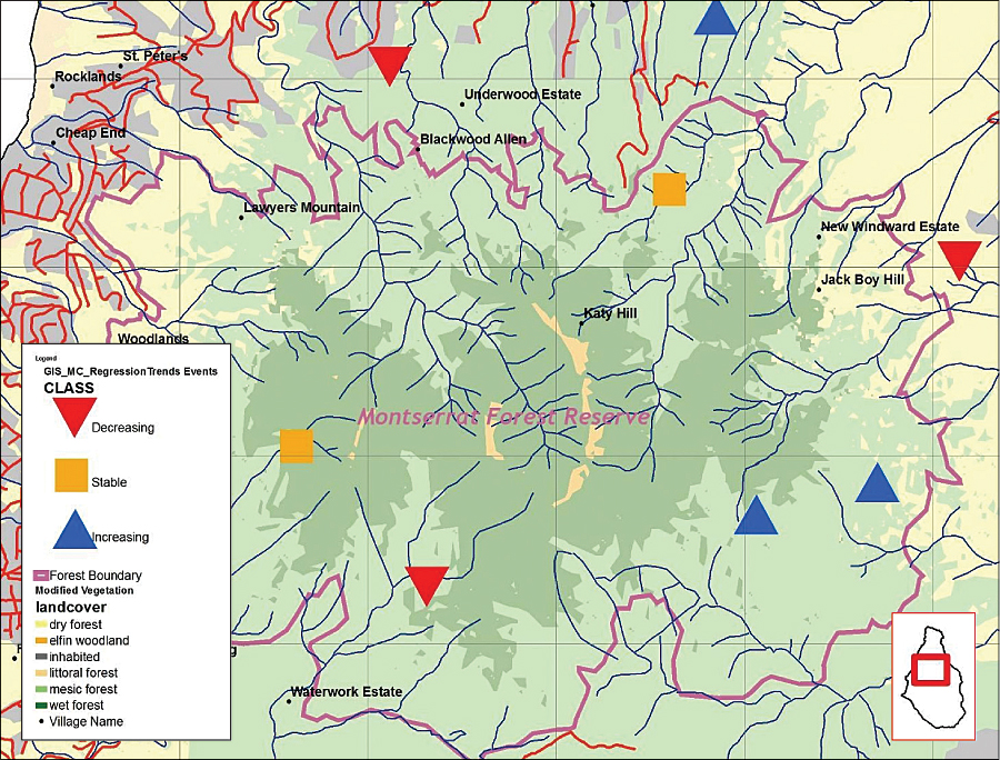
In the eastern Caribbean Sea, Montserrat is another UK overseas territory, approximately 12 miles (20 kilometers) west of Antigua. After a volcanic eruption in 1997, the population dwindled from 11,000 to 3,500 and is now settled in only one-third of the island. These few people on the island are in need of GIS to assist them in mapping safe zones and planning for permanent homes and services away from the dangerous area around the volcano. GIS is also used to map endangered species in the Center Hills area, including the curiously named mountain chicken, a frog that is a local delicacy and has been unfortunately decimated by a fungal disease. Work by the Department of Environment in Montserrat—supported by the likes of the Durrell Wildlife Conservation Trust; the UK Royal Society for the Protection of Birds; and the Royal Botanical Gardens, Kew—is helping protect endangered species like the mountain chicken. Led by GIS manager Lavern Rogers-Ryan, who works in the Montserrat Physical Planning Department, the GIS team uses ArcGIS to cover the requests of clients on the island, including updating the land cadastre and mapping for natural disasters and environmental protection. Comments Rogers-Ryan, "Assisting the Department of Environment in mapping its data opened our eyes to the spatial comparisons across the island." Mills assisted in developing a database and training field staff in how to make simple maps. Rogers-Ryan emphasizes, "This assistance helped me better structure my data to provide wider services to several government departments without being overwhelmed by the work." GIS Used to Evaluate Land Resources for St. Kitts in a Postsugar EraSt. Kitts (also called St. Christopher) is part of an independent, twin-island federal state with the island of Nevis. Both islands have a total population of 39,000 and achieved their independence in 1983 when the British made them the smallest independent state in the Western Hemisphere. St. Kitts has a land area of 65 square miles (168 square kilometers) with extremely fertile soils used primarily for sugar production for the past 350 years.
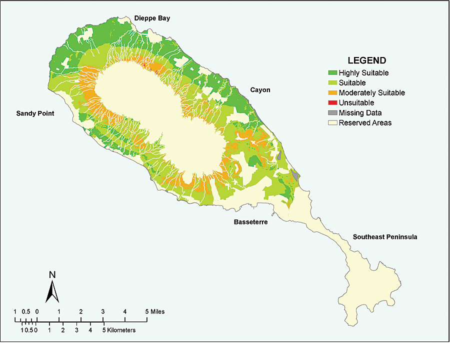
Fluctuating commodity prices and reduced European Union trade preferences have made the island's reliance on single-crop agriculture an economic vulnerability. To address such vulnerabilities, in 2005 the government of St. Kitts and Nevis (GoSKN) made the decision to close the sugar industry and vigorously pursue its economic diversification by placing emphasis on more viable alternatives, such as tourism and nonsugar agriculture, including field crops and livestock. One of the major challenges of this effort is adopting careful planning to ensure that the island's land resources previously utilized by the sugar cane crops are optimized for the long-term economic, social, and environmental sustainability of the country. After the closing of the sugar industry, the GoSKN Physical Planning Department (PPD) and Department of Agriculture spearheaded the planning for the agricultural transition. A land resource analysis study was conducted using ArcGIS (ArcView) to identify the most suitable lands for six nonsugar agricultural activities: vegetable crops (e.g., tomatoes, peppers), pineapples, fruit tree crops (e.g., sugar apples, guava), field crops (e.g., cassava, sweet potato), livestock production, and pasture/grass (e.g., guinea grass for feeding livestock). "While specific areas have been quantified based on suitability," says Daniel (former PPD staff member and lead researcher on the study), "an added benefit of this study was the ability to identify, compare, and quantify areas for uses beyond agriculture. We were able to evaluate future land use, such as housing for tourism, industrial, and residential, along with suitable lands for nonsugar agricultural activities. Using GIS, we were able to see the bigger picture of how to develop areas for the benefit of the community." Mapping Resources on Rodrigues Island to Sustain Human ActivityRodrigues is a partly autonomous island found approximately 400 miles (650 kilometers) east of its sister island, Mauritius. Third largest of the Mascarene Islands, Rodrigues has 40,000 people who live off reef and subsistence farming and has few support services and only a fledgling tourism industry. Shoals Rodrigues, a nongovernmental organization working closely with the island's government, the Regional Assembly, conducts marine research, education, and training about the extensive reef area, which extends over twice the size of the land itself. One major activity is assessing the extent and health of the marine resources, including the corals, sea grasses, and mangroves. With the support of the Universities of Newcastle and Bangor in the United Kingdom, Shoals Rodrigues created a map of the basic reef structure using supervised classification of Landsat Enhanced Thematic Mapper data, with an eye to using QuickBird satellite imagery and ArcView in the near future for the more detailed map of the resources, as well as in educational work and governmental planning. More InformationFor more information, contact Alan Mills, Alan Mills Consulting, Ltd. (tel.: 44-1622-813214, e-mail: alanpmillsuk@yahoo.co.uk), or Edsel Daniel, Vanderbilt University (tel.: 615-322-3459, edsel.b.daniel@vanderbilt.edu). |