ArcNews Online
Fall 2010
[an error occurred while processing this directive]Imagery Is Core to GIS
Imagery and Rasters in ArcGIS 10
Highlights
- Esri's imagery technology is now integrated into all aspects of the ArcGIS system.
- A mosaic dataset is a new geodatabase data model used for managing and disseminating imagery.
- ArcGIS enables quick access and visualization of imagery with other geospatial data.
At version 10, imagery management and exploitation has become a core part of ArcGIS technology. Whether it is used as a context-providing basemap, the source for creating new datasets, or support for geospatial analysis, most users consume imagery. Imagery is everywhere—from the desktop to the server and from the field to the cloud—and it is now integrated into all aspects of the standards-based ArcGIS system. This full integration is new and provides the foundation for building advanced workflows that work with all types of geospatial data, including imagery.
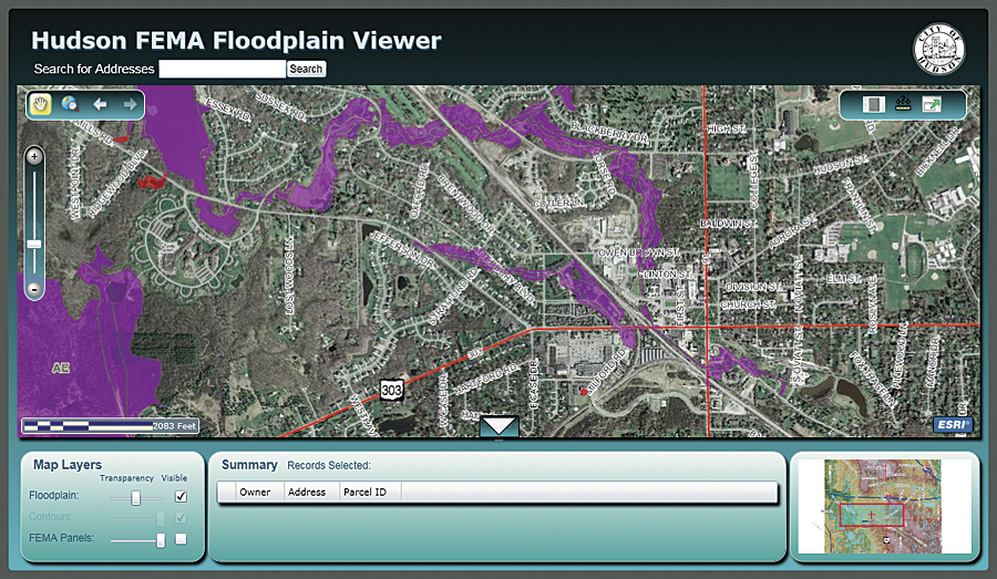
The City of Hudson, Ohio, integrated imagery and a U.S. Federal Emergency Management Agency floodplain map to assist with resident appeals submissions for the new floodplain designations.
Esri's imagery technology is now integrated into all aspects of the ArcGIS system. Here are some examples:
- ArcGIS Desktop—The complete desktop environment for imagery management, analysis, and use.
- ArcGIS Server—Versatile solution for disseminating individual images, static caches, and powerful dynamic image services.
- Mobile—Everything from Tablet PCs to smartphones, including iOS 4, Windows Mobile, and the forthcoming Android API, can use imagery to enhance field operations.
- Web APIs—Integrates image services from ArcGIS Online and image services powered by ArcGIS Server into these flexible and customizable browser-based applications.
- Geodatabase—The repository for organizing, managing, and integrating imagery with other geospatial data.
- Geoprocessing—Advanced capabilities to enable workflows that can incorporate image processing and analysis.
ArcGIS is a standards-based information system that is easily integrated with other enterprise systems or extended and customized by Esri's partners, which provide domain expertise for focused and specialized solutions.
Who Uses Imagery?
Imagery is everywhere. Here are a few examples:
After Cyclone Nargis devastated Myanmar (formerly called Burma) in May 2008, the Foreign Agriculture Service of the United States Department of Agriculture used imagery to monitor the condition of the country's agricultural lands, which was critical to plan and track relief efforts.
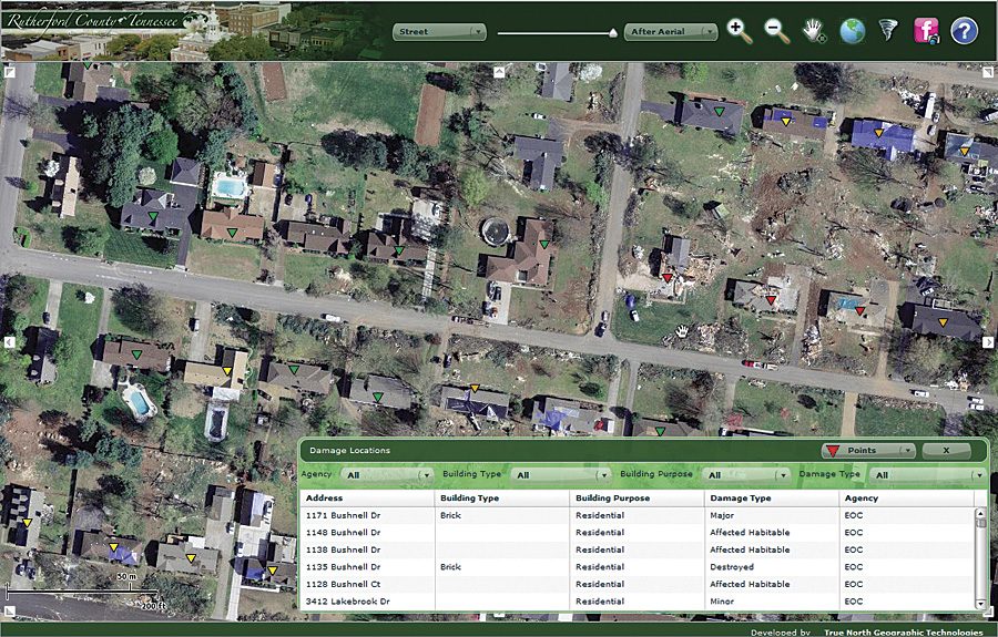
Rutherford County, Tennessee, used imagery to show the before and after effects of an F4 tornado that hit the county in April 2009.
The Woods Hole Research Center in Falmouth, Massachusetts, uses imagery in its environmental and conservation efforts. It is tracking carbon footprints by measuring biomass, deforestation, and land use.
Ste. Michelle Wine Estates uses multispectral imagery over 3,500 acres of grapes in Washington and Oregon to analyze canopy density and plant and environmental health, track temporal changes, and generate optimized harvesting schedules.
The Indian Space Research Organisation uses the imagery it collects from its satellites to support many valuable societal applications and government agencies.
Imagery at ArcGIS 10
The integration of imagery into all aspects of the ArcGIS 10 system makes it easy for all industries to integrate imagery. The improvements to managing, disseminating, visualizing, and analyzing imagery mean that it is easy to organize and maintain, is right at the fingertips of those who need it when they need it, looks great and displays quickly, and provides more actionable information.
Countless Images, One Dataset
ArcGIS meets all the demands of imagery management, from independent users with small collections of image files to organizations with large collections of processed imagery to organizations collecting new imagery. The new mosaic dataset is the simple solution to managing entire imagery collections within the geodatabase.
The mosaic dataset enables collections of images and rasters to be stored as a catalog and viewed as a single image. The collection or each image can have its own metadata and image processes. A mosaic dataset is accessible to applications both as an image, with all required processing applied on the fly, or as a catalog of footprints and metadata. Image processing rules may be defined automatically based on type of image but can also be user defined and refined. The mosaic dataset is supported in both file and enterprise geodatabases and accessible in all editions of ArcGIS Desktop, although an ArcInfo or ArcEditor license level is required to create or edit mosaic datasets.
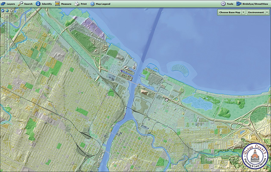
This application allows citizens of Brown County, Wisconsin, to combine historical aerial imagery with various county maps to learn more about the neighborhood they live in and how it's changed over the past 70 years.
The mosaic dataset quickly catalogs different image sources that range from individual files to imagery collections, as well as directly from sensors. It supports most existing raster and imagery formats to simplify migration and implementation workflows. Imagery does not have to be reprocessed as the existing datasets are referenced and additional processing is applied upon access.
Since the mosaic dataset does not move or duplicate imagery, storage requirements are minimized, and redundant imagery is eliminated.
The mosaic dataset directly supports imagery captured from satellites, aerial photography, and other sensors. This is extremely useful for organizations that collect, process, and distribute their own imagery. The processing to be applied can be automatically assigned based on imagery type, or processing templates and tools can be used to refine the imagery processing.
Right at the Fingertips
The value of even the most well-managed imagery collections is limited if the imagery is not in the hands of those who need it when they need it. ArcGIS Server provides the power and flexibility to unshackle imagery and deliver it in less time and with less effort. ArcGIS Server can disseminate a single image file or a vast collection with equal ease. It serves imagery as part of a map service or directly as an image service using GIS services, which can be accessed directly or integrated with other services and applications.
The map service is the classic ArcGIS Server method for publishing maps authored in ArcGIS Desktop to the Web. When these services are served as static map caches, they are the most scalable way to deliver imagery over the Web. This makes them ideal basemaps.
ArcGIS Server uses image services to provide dynamic access to imagery and raster data for visualization and analysis. Image services are a core capability of ArcGIS Server to efficiently serve imagery stored in a raster dataset.
The ArcGIS Server Image extension enables image services to serve mosaic datasets. These Image extension-powered services can take advantage of all the advanced functionality found in the mosaic dataset, such as dynamic mosaicking and on-the-fly processing. Dynamic mosaicking is the ability to handle overlapping imagery and enables both the author of the mosaic dataset and the user accessing it to redefine the order of the imagery so that the most appropriate image is displayed on top.
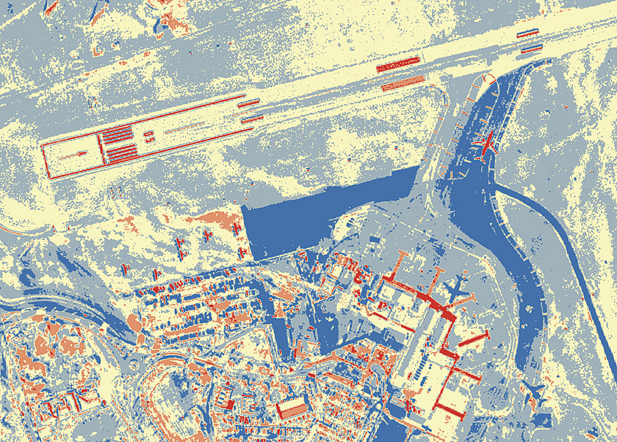
Temporal analysis is simple with the Difference tool in the Image Analysis window. The above result highlights the differences between 2005 and 2008 imagery of the Queenstown Airport. Notice the new Jetways in red and parking apron expansion in blue.
This functionality is critical for organizations that have different groups exploiting different information from the same imagery collection. Instead of creating a new image service for each need, the different groups can all access the same image service.
Imagery at the Speed of Light
The imagery technology built into the core of ArcGIS enables quick access and visualization of imagery with other geospatial data, simplifying workflows and reducing costs. Supporting nearly all image sources, ArcGIS makes it easy to visualize imagery through a variety of platforms, including desktop, server, cloud, Web, and mobile.
The accelerated image display added in version 10 vastly improves the ability of ArcGIS to quickly display imagery and other geospatial data. It uses a combination of hardware and software rendering, as well as localized caching, to optimize draw time and provide smoother pan and zoom capabilities. Even imagery accessed through Internet image services will show dramatic improvements. This allows continuous panning and zooming of both imagery and the new basemap layer. ArcGIS 10 means less time waiting for imagery to load and display and more time to analyze data and make decisions.
More than Just a Pretty Picture
Imagery is more than just a pretty picture or a background for "real" GIS layers. It provides real knowledge for real analysis so users can make real decisions. Imagery is valued because it is not preinterpreted and so retains all the original information, making it a perfect choice for advanced analysis capabilities, including feature extraction, elevation and terrain models, classification, suitability, and measurement.
ArcGIS Desktop includes the new Image Analysis window, which brings together over 25 imagery tools to enhance and interpret imagery. This context-sensitive window provides one-click access to many display and on-the-fly processing functions, which include
- Sliders for contrast, brightness, transparency, and gamma
- One-click dynamic range adjustment
- Resample and stretch
- Composite bands to integrate and customize band combinations for multispectral imagery
- Pan sharpening and orthorectification
- Normalized Difference Vegetation Index calculations
- Shaded relief of a raster elevation dataset
The tools in the Image Analysis window are readily accessible and simple to use. Functions are applied on the fly; no new datasets are created, and the results are available instantly. This is very different from traditional linear workflows that waste time and storage, creating intermediate outputs. Naturally, the on-the-fly results can be easily exported and saved.
Pixel Perfect
Simply put, imagery is a core component of a complete GIS. ArcGIS 10 provides a comprehensive system that integrates imagery into every GIS workflow. It is now faster, easier, and simpler to manage, disseminate, visualize, and analyze all geospatial information, including imagery, to make the best decisions possible. Furthermore, Esri partners provide the domain expertise that our customers require, as well as advanced imagery analysis tools, image collection, processing and distributing tools, and industry-customized solutions for specific industries.
More Information
For more information, visit www.esri.com/imagery.
Also see "Imagery is Core" poster.
See also "Why Use Imagery or Raster Data?"