ArcGIS Online: What's New

In ArcGIS 10.1 for Desktop, users can publish a service directly to ArcGIS Online.
This regular column contains information about the latest updates to ArcGIS Online basemaps; new content contributed by Esri and the user community; and information about the latest release of ArcGIS.com, the website where users can access online content and capabilities.
Updated Basemap Services
Contributions to World Topographic Map, one of the three community basemaps being built and expanded with detailed data from GIS organizations around the world, continue to grow. The latest updates to World Topographic Map include data from the Dutch Kadaster, which contributed airports, buildings, and neighborhood data from its topographic database; the Spanish Instituto Nacional de Estad�stica and Instituto Geogr�fico Nacional/Centro Nacional de Informaci�n Geogr�fica, which contributed administrative boundaries, buildings, hydrology, landmarks, parks, and airports data; the Czech Office for Surveying, Mapping, and Cadastre, which contributed administrative boundaries, landmarks, parks, roads, hydrology, building, contours, hillshade, and vegetation data; and British Ordnance Survey, which contributed data for several major cities in the United Kingdom that includes administrative boundaries, neighborhood, railroads, roads, hydrology, vegetation, and landforms data.
The latest release of World Street Map includes updates and additional levels of detail for areas where there is already street-level data, including North America, South America, Europe, and Australia. The latest release of World Imagery Map includes updates for the United States and additional imagery for Spain.

National Geographic World Map utilizes and extends a century-old cartographic tradition to the digital age.
World Topographic Map, World Street Map, and World Imagery Map are updated frequently with data from organizations around the world, including local governments and national mapping agencies, as well as the latest commercially available datasets. Contributions from user organizations are received through the Community Maps Program, which any data provider interested in making its content broadly available can join. Contributed content is blended into the basemaps, which are published and hosted by Esri and made freely available.
New Map Services
Ocean Basemap, released in June 2011 for World Hydrography Day, is designed for marine GIS professionals and anyone interested in ocean data. Delivered as a map service, it includes bathymetry, marine water body names, undersea feature names, and derived depth values in meters. Authored at a scale of 1:1,000,000 and using a muted color palette, this basemap is perfect for overlaying operational or other user-specific content for applications in nautical charting, port security, and marine conservation. Ocean Basemap blends publicly available, authoritative ocean data sources into one cartographically uniform basemap that is freely accessible.
National Geographic World Map is a collaboration between National Geographic and Esri to produce a cartographically distinctive basemap that reflects National Geographic's cartographic design, typographic style, and map policies. This new high-quality, multiscale basemap is built using National Geographic's cartographic data, as well as data from third parties, and complements the existing ArcGIS Online basemaps. It is made available as a tiled cache service and is perfect for use as a reference map in applications that provide general information or as an educational resource.
A number of datasets, specifically described in Office of Management and Budget (OMB) Circular A-16, have been published in ArcGIS Online as map services, web maps, and layer packages in the A-16 group and can be used as basemaps or operational layers to support a variety of applications. These US-specific datasets include annual and quarterly bankruptcy filings, population percentage estimates of diabetes and obesity incidence, soil data, and stream gauges and water stations.
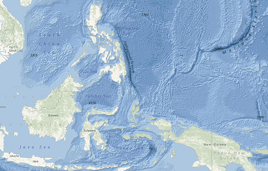
Ocean Basemap shows seabed morphology and is designed for users to overlay their operational data.
Data from World Bank has also been published as web maps and layer packages under the International Maps group in ArcGIS Online. These web maps and layer packages provide information about global Internet access; mobile cellular subscriptions; literacy rate; labor force total and participation; and a number of other datasets describing populations, spending, and infrastructure.
Drag-and-Drop Capability
Users now have the ability to add shapefiles, text (TXT and CSV), and GPX files directly to their web maps by either dragging the data from their computers directly onto their maps or adding it with just the click of a button in the ArcGIS.com map viewer or ArcGIS Explorer Online. Once the data has been added, users can configure pop-up windows to present attribute information in both tabular and chart form. The data can also be displayed by choosing from several classification methods so that it can be rendered using a variety of symbols.
When data is added to a web map, the ArcGIS.com map viewer and ArcGIS Explorer Online automatically add the location information from the file, draw features for each item, and then store the information in the map. In addition to the above-mentioned formats, users can also add Open Geospatial Consortium, Inc., Web Map Service layers to the ArcGIS.com map viewer and ArcGIS Explorer Online by clicking the Add button and entering the URL to the service. The ArcGIS.com map viewer also supports adding KML layers.
Enhanced Group Management
In ArcGIS Online, groups are a great way for different people to share their interests or work together on a special project. Users can create public groups that anyone can join to help others find geographic content that pertains to a specific topic, for example, the ArcGIS for Local Government group. Users can also create private groups and allow others to apply to join the group. Private groups are useful while working on projects where data and maps need to be shared and models and analyses need to be interpreted and fine-tuned before results are published to a broader audience. Previously, group owners could only manage the content that they owned. Now, group owners can also manage content they don't own. Group owners can add public content and then share it with a specific group, which is useful when the group owner finds content that relates to the focus of a group but the owner of the content is not a member of the group.
To start using ArcGIS Online content and capabilities, visit ArcGIS.com.
See also "Tailor ArcGIS Online to Your Organization."