Czech Republic Protects Its Citizens
Safety Center Empowers Public Safety Agencies
Highlights
- When an emergency call comes in, operators use ArcGIS to locate the caller's position for both landline and mobile phones.
- Police of the Czech Republic, as well as Municipal Police of Ostrava, use ArcGIS to track and monitor city crime rates.
- Public safety personnel use GIS to analyze and understand the impacts of floods, fire hazards, hazardous materials, storms, and more.
The modern world of public safety relies on information as an invaluable resource. In many ways, it's as important to public safety agencies as physical tools, such as a fire axe, ambulance, or police radio. As more organizations become tech savvy and build information systems and networks, the issue becomes how to integrate and properly use large volumes of information. Moreover, as effective as emergency medical services, law enforcement, and fire service response operations may seem, fast access to critical information, when and where it's needed, improves the delivery of public safety services.
The Czech Republic understands this well. A recently launched regional operations hub—the Moravian-Silesian Region (MSR) Integrated Safety Center (ISC)—is bringing together networks and supplying staff with robust technology tools using Esri software.

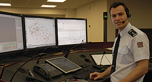
The Integrated Safety Center dispatcher's workplace.
Today, separate public safety units share a central control room, where they use ArcGIS for efficiently deploying personnel and equipment. The ArcGIS system enables decision makers to access relevant information that is delivered via a geospatially driven common operating picture to provide better services through improved decision making.
"We cannot imagine doing this work without integrated GIS," says Petr Faster, fire officer, Operational Management Division, Moravian-Silesian Region Fire Department.
The Moravian-Silesian Region Integrated Safety Center
In 2001, a new administrative classification for the Czech Republic came into existence, and 14 regions in the Czech Republic were formed. One region, Moravian-Silesian Region, came up with the idea to create a unique regional workplace for all public safety staff and units. Its goal was to coordinate safety efforts, and the MSR Integrated Safety Center was formed in 2011. The ISC takes advantage of several technologies, with GIS serving as a foundational platform. This is in large part due to the efforts of the region's fire department and its previous GIS success.
Faster has worked in the Operational Management Division of the fire department of the MSR since the mid-1990s. He first used Esri GIS for MSR public safety more than a decade ago. Recognizing the value GIS would bring to public safety efforts, he championed the deployment of the technology at ISC.
"Implementation of GIS in fire departments in each region helped to improve GIS awareness," says Faster. "The Moravian-Silesian Region wanted to go to the next level and build a single center that served the entire region. After almost 10 years of constructing, developing, [and] testing, the ISC started its full operation."
ISC, empowered with advanced information and communication technology, replaced 15 operational dispatch centers. The benefits of moving this work to the MSR ISC include the elimination of data redundancy and duplicated work, and the synergy that results from operating within a unified information system framework.
Today, ISC receives all emergency calls in the Moravian-Silesian Region. Emergency medical services, the fire brigade of the MSR, Police of the Czech Republic, Municipal Police of Ostrava, and crisis management personnel all operate out of ISC. Together, there are 31 dispatchers: 8 for fire/rescue, 10 for medical, 3 for municipal police, and 10 for the Czech Republic Police Department.
When an emergency call comes in, operators use ArcGIS to locate the caller's position for both landline and mobile phones.
"Integration through GIS makes the coordination of all the public safety units easier," says Faster. "We solve cases together from one place, using the same data through common visualization. GIS is essential for managing emergency situations in the region."
Once a call is located, operators can quickly dispatch the closest appropriate personnel and resources.

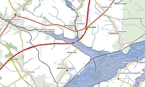
For large-scale emergency preparedness, GIS is used to analyze and understand the impacts of floods, fire hazards, hazardous materials, storms, and more. This is a visualization of the affected area in the case of a hundred-year flood.
Operations staff and managers also use GIS to analyze, visualize, and take action for major events, such as natural disasters. Once the emergency is visualized on the map, managers can quickly drill down and access more detailed information that is contained in local databases or other remote sites. Remote access can include web services, such as real-time weather reports; traffic video; and other dynamic, sensor-based data.
Spatial planning and modeling enable proactive work before emergencies happen, such as modeling response times and reviewing the history of incidents based on the time of day or day of the week. GIS also assists in positioning resources for efficient emergency response. This helps establish staffing patterns by resource type and capability based on historic call volume patterns. Resource deployment becomes a science-based methodology.
For emergency medical services, operators use maps and navigate ambulances to their destination. Once ArcGIS has assisted in locating the caller and the incident, routing is performed based on traffic conditions. As ambulances are dispatched and assigned, their status on the GIS viewer changes to Unavailable. Dispatch officers then use the software to help designate available units to provide coverage and optimized response for subsequent emergency calls.
The fire department of the MSR maintains this capability as well. As units are dispatched to emergency locations, preplans (if they have been prepared for the specific location) automatically become available for the first responders as they are en route. ISC cameras can be located and activated for areas in which emergency units are dispatched, providing commanders with a firsthand visual account of events on the ground before vehicles arrive.
For daily operations, digital mapping enables intelligent, interactive visualization of data and analysis with the results being provided through a map. This allows fire service personnel to produce risk assessment plans by mapping streets, buildings, and utility infrastructure and overlaying that data with population data, hazardous material locations, and high-value protection assets (schools, hospitals, government buildings, etc.). They can perform historical analysis to look at the likelihood of certain disasters impacting people and property based on location and proximity to natural and man-made hazards. Decisions to mitigate these exposures can then be made to increase preparedness and reduce emergency consequences and loss. Mitigation decisions can range from establishing better construction policies in exposed areas to assuring rapid response capability in high-risk areas.
Police of the Czech Republic, as well as Municipal Police of Ostrava, use ArcGIS to track and monitor city crime rates. Both agencies can map the locations of incidents, known suspects, probationers and parolees, and other related data for crime and investigative analysis. Tracking vehicles and personnel helps staff with daily watch command operations. This enables commanders to understand ongoing activities, planned security events, incident status, and overall jurisdictional requirements. It also assists in positioning units, initiating patrols in the field as circumstances change, and deploying officers to emergency incident or crime scenes.
For large-scale emergency preparedness, GIS is used to analyze and understand the impacts of floods, fire hazards, hazardous materials, storms, and more. The goal is to protect populations, critical infrastructure, and natural resources.
Future applications include the deployment of in-vehicle navigation for emergency vehicles. This capability will also enable first responders to visualize geographic and other data from ISC databases to support first responder situational awareness and emergency location preplan data.
"Having map and data integration for all the safety units in one building is the key benefit for us," says Faster.
For more information, contact Petr Faster, fire officer, Fire Rescue Department, the Moravian-Silesian Region (e-mail: petr.faster@hzsmsk.cz).