Ecosystem Services—Learning to Leverage Natural Capital
By Frederick Steiner, Dean, School of Architecture, The University of Texas at Austin
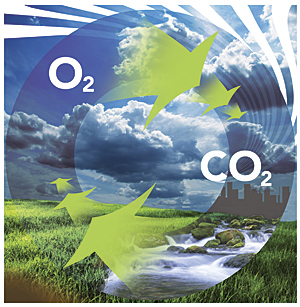
 The ecosystem services concept helps us understand and describe the benefits that the environment provides to humans, benefits that we have traditionally viewed as free and would have to supply for ourselves if our surroundings ceased to furnish them. The environment provides direct services, including air, minerals, food, water, and energy. It furnishes regulating services, such as the purification of water, carbon sequestration, climate mitigation, waste decomposition and detoxification, crop pollination, and pest and disease control. The environment supplies support services, including nutrient dispersal and cycling, as well as seed dissemination. The environment also yields cultural benefits, such as intellectual and spiritual inspiration, recreation, ecotourism, and scientific discovery.
The United Nations 2005 Millennium Ecosystem Assessment stressed the value of ecosystem services. For instance, the authors of the assessment noted the following:
- The assessment focuses on the linkages between ecosystems and human well-being and, in particular, on "ecosystem services." An ecosystem is a dynamic complex of plant, animal, and microorganism communities and the non-living environment interacting as a functional unit. . . . Ecosystem services are the benefits people obtain from ecosystems. . . . The human species, while buffered against environmental changes by culture and technology, is fundamentally dependent on the flow of ecosystem services.
The Gal�pagos Islands provide an example of ecosystem services at work. After Europeans discovered the archipelago in 1535, these hardscrabble, barren volcanic islands suffered centuries of abuse by buccaneers, whalers, settlers, and scientists before the Ecuadorian government created a national park in 1959. Some 97 percent of the Gal�pagos Islands (1,714,000 acres [693,700 hectares]) is in the national park. In 1986, the waters surrounding the islands received protection through the creation of the Gal�pagos Marine Reserve.
As a result, global science and the Ecuadorian economy have benefited. The Gal�pagos Islands continue to generate new biologic and geologic knowledge. Meanwhile, the archipelago has become a popular destination for ecotourism and recreation. These activities create jobs and revenue for Ecuador.
New York City's watershed protection efforts provide another example of ecosystem services. The watershed covers approximately 2,000 square miles (5,180 km�). Nineteen reservoirs supply 1.2 billion gallons (4.5 billion liters) of drinking water daily to nine million New Yorkers. In the 1990s, faced with the prospect of spending $8 billion on a new water filtration plant that would cost $300 million annually to operate, the city instead decided to invest $1.2 billion over 10 years to restore and protect its watersheds. These funds were used to purchase land and invest in environmentally sound economic development in the watershed.
In addition to benefiting New York City residents and reducing costs to urban taxpayers, the people who live in the watershed gained value from the ecosystem services approach. Everyone has good, clean water. Farmland has been preserved, habitat created, and recreational opportunities expanded.
Landscape architects, community and regional planners, conservationists, architects, engineers, and policy makers can employ the ecosystem services concept at many scales—from the megaregion to the site. GIS and GeoDesign technologies can contribute to these cross-scale applications because of their capacities to capture, manage, analyze, and display geographic information, as well as assist in the processes of planning and design.
The Rise of the Megas
Several researchers, led by the Regional Plan Association (www.america2050.org), have noted the blurring of large metropolitan areas into a new geographic scale, called a megaregion, with interlocking 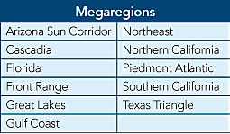 economic, ecological, and transportation systems. Eleven megaregions have been identified in the United States, including the Northeast, which spans several states, and the Texas Triangle, which is contained within a single state.
The Regional Plan Association and others estimate that over 70 percent of the nation's population and jobs are located in these megaregions. These megaregions are likely to gain even more population and economic growth in the future: one estimate is that they will account for 50 percent of the US population growth and 66 percent of our economic growth over the next 40–45 years (www.angeloueconomics.com/megaregions.html). Megaregions provide an example of "agglomeration economics," which Harvard economist Edward Glaeser defines as "the benefits that come from clustering cities."
This growth provides opportunities and challenges for environmental design and planning. One opportunity is to view environmental processes at the scales at which they occur: watersheds, rivers, mountain ranges, aquifers, and weather patterns. A challenge is that the detrimental effects associated with rapid growth are threatening environmental quality. Large-landscape protection can help mitigate negative environmental impacts.
Northeast Megaregion
In response, the Regional Plan Association has joined others to produce the Northeast Landscapes Initiatives Atlas (www.rpa.org/northeastlandscapes). The goal is to protect watersheds, wildlife habitat, and other landscape-scale processes in the 13-state Northeast megaregion. The Regional Plan Association-led team is using GIS to understand spatial interrelationships. The team has produced an inventory of public and private landscape conservation initiatives in the Northeast megaregion.
The GIS-based atlas will contain three types of data: landscape initiatives, conservation context, and development context. Robert Pirani of the Regional Plan Association notes that the delivery and valuation for ecosystem services are key values added for landscape planning:
- Many ecosystem services are delivered through landscape-scale processes: source water protection, riverine and coastal flood management, sustaining fish and wildlife populations, and the agglomeration needed for viable agricultural and forestry economies.
- Monetizing these services depends on creating a market. Landscape conservation initiatives are the right scale for enabling viable markets. As institutions, land trusts and conservancies potentially can be the institutions that bridge upstream and downstream sellers and buyers.
The Texas Triangle Megaregion
The Texas Triangle megaregion is formed with Houston and San Antonio at the base and Dallas and Fort Worth at the apex. By 2050, some 35 million people, or 70 percent of the population of Texas, will live in the triangle's four metropolitan areas: Dallas-Fort Worth, Houston, San Antonio, and Austin. The Edwards Aquifer supplies water to metropolitan San Antonio and Austin, as well as to many farmers and ranchers. In fact, this immense, prolific aquifer is the sole source of water for San Antonio. As a result, the protection of the aquifer is essential for the future of the Texas Triangle.
The Edwards Aquifer roughly underlies what is known as Texas Hill Country. In addition to being a rich source of water, the landscape contains important wildlife habitats and a significant cultural history. The landscape is also quite scenic and valuable for recreation. As a result, the ecosystem services provided by the Hill Country are many. In response to growth pressures in the Hill Country and over the aquifer, the cities of San Antonio and Austin, as well as several counties, have purchased conservation easements to protect the assets of the Hill Country.
The nonprofit Hill Country Conservancy contributes much to these government efforts. In addition to purchasing easements, this land trust is also engaged in the GIS mapping of the landscape assets of the Hill Country. The conservancy employs GIS at several scales—from individual parcels with conservation easements to the entire Hill Country region. While the Hill Country Conservancy has not quantified the ecosystem services provided by the land it protects, it certainly contributes to enhancing conservation values that benefit the whole region. These conservation values are the basis on which the Internal Revenue Service may grant tax credits for easement donations. Some benefits/services that have been documented include scenic views, aquifer recharge, high-quality storm runoff, habitat, and prime farmland. Beyond the explicitly documented benefits, the land trust is preserving grasslands that have the potential to sequester carbon and riparian areas that help prevent flooding and erosion.
Sustaining Sites
 The ecosystem services concept is also being employed at the site level. The Sustainable Sites Initiative, known as SITES, is a joint effort by the American Society of Landscape Architects; Lady Bird Johnson Wildflower Center of The University of Texas at Austin; and the US Botanic Garden (www.sustainablesites.org). A goal of SITES is to produce the outdoor equivalent to the US Green Building Council's successful Leadership in Energy and Environmental Design (LEED) program. The SITES team has both learned from LEED and relied on ecosystem services. The team identified specific ecosystem services that designers can strive to protect or regenerate at the site scale, which include
- Global climate regulation—Maintaining balance of atmospheric gases at historic levels, creating breathable air, and sequestering greenhouse gases
- Local climate regulation—Regulating local temperature, precipitation, and humidity through shading, evapotranspiration, and windbreaks
- Air and water cleansing—Removing and reducing pollutants in air and water
- Water supply and regulation—Storing and providing water within watersheds and aquifers
- Erosion and sediment control—Retaining soil within an ecosystem, preventing damage from erosion and siltation
- Hazard mitigation—Reducing vulnerability to damage from flooding, storm surge, wildfire, and drought
- Pollination—Providing pollinator species for reproduction of crops or other plants
- Habitat functions—Providing refuge and reproduction habitat to plants and animals, thereby contributing to conservation of biological and genetic diversity and evolutionary processes
- Waste decomposition and treatment—Breaking down waste and cycling nutrients
- Human health and well-being benefits—Enhancing physical, mental, and social well-being as a result of interaction with nature
- Food and renewable nonfood products—Producing food, fuel, energy, medicine, or other products for human use
- Cultural benefits—Enhancing cultural, educational, aesthetic, and spiritual experiences as a result of interaction with nature
Rating System
As a result of four years of research, the SITES team released guidelines and performance benchmarks in 2009. This rating system includes 15 prerequisites and 51 credits that cover all stages of development—from site selection to landscape maintenance. The rating system is currently being tested through over 150 pilot projects representing a diverse cross section of project types, sites, and geographic locations. The pilot projects include a range of types and sizes. The project types include parks and open spaces, educational and institutional, commercial, residential, streetscapes and transportation, gardens and arboretums, government complexes, mixed use, and industrial. The project sizes range from less than 1 acre (.4 hectares) to over 500 acres (202.3 hectares). Existing land uses include greyfield, greenfield, and brownfield sites.
Pilot Projects
Thirty-four states and the District of Columbia, Canada, Iceland, and Spain are represented in the pilot projects. Two examples of these pilot projects are Tempe Transportation Center in Arizona and Burnham Centennial-Midewin National Tallgrass Prairie in Illinois. The Tempe Transportation Center project team includes A Dye Design; City of Tempe; Michael Baker, Jr., Consulting Engineers; and Otak+Architekton. This transit plaza replaces a 2.7-acre (1.1-hectare) parking lot, linking the new METRO light rail to local/regional bus routes, bike facilities, and Arizona State University. The mixed-use LEED building provides transit-oriented retail/restaurant facilities at the plaza, where storm water and gray water collection for irrigating native plants and vegetated bus shelters sustainably integrate public spaces with pedestrian circulation at a busy urban multimodal hub.
Burnham Centennial-Midewin National Tallgrass Prairie is located in Wilmington, Illinois. Its design team includes the Conservation Design Forum, dbHMS, and Wheeler Kearns Architects. Two separate but integrated open-air visitor and education areas are proposed for construction in this area, which was once part of the Joliet Army Ammunition Plant. Design elements include outdoor classrooms, picnic areas, overlook stations, trails, and interpretive signage about the natural and cultural history of the site. All aspects of the project are intended to demonstrate green design principles, including capturing and cleaning runoff before release into the restored prairie.
The pilot project stage will be completed in June 2012. Lessons learned from the pilot projects will be incorporated into the formal release of the SITES rating system to the marketplace in 2013.
From the pilot projects, it is already clear that GIS plays an important role in designing sustainable landscapes, which could be expanded through GeoDesign. In addition to the mapping ability of GIS, it is also useful for calculations and data submittals. For example, a site assessment is required as a prerequisite, which can be submitted in GIS.
Advancing Ecosystem Services
National and local organizations and agencies increasingly use ecosystem services to advance their missions. For instance, the Trust for Public Land notes that the environmental and social benefits of parks and open space (such as improved recreation and health, as well as cleaner water and air) also engender economic benefits (such as increased tax revenue and an advantageous ability to attract businesses) (www.tpl.org). The Trust for Public Land has pursued this mission through its GIS-based Greenprinting tool. Greenprinting enables local officials and conservationists to identify and rank environmentally significant and fragile areas. Central Texas is one place where Greenprinting has been employed. The Edwards Aquifer and other environmental assets have been mapped with the Greenprinting tool.
In Philadelphia, University of Pennsylvania's student-faculty clinical design consulting practice, Penn Praxis, used economic arguments as the basis for its 2010 plan to add 500 acres (202.3 hectares) to the city's park system. In Green 2015: An Action Plan for the First 500 Acres, the Penn Praxis team notes that converting vacant lots into community gardens can raise local property taxes and reduce the need for police and fire services. Furthermore, the team observes that replacing impervious asphalt surfaces with rain-absorbing green areas has already saved the city $35 million since 2006. In addition, the Penn Praxis team reports that the city's existing open space has generated over $400 million in health-related cost savings.
The Gund Institute for Ecological Economics at the University of Vermont has joined others to create a web-based tool for advancing ecosystem services globally called Artificial Intelligence for Ecosystem Services, or ARIES (www.uvm.edu/giee). ARIES researchers map benefits, beneficiaries, and service flows to help users visualize, value, and manage ecosystems. This technology assists users in making rapid ecosystem service assessment and valuation. It is open-source software that is free to all nonprofit users. ARIES integrates information from an extensive database, from global- to local-scale GIS, combined with ecosystem service models. ARIES is helping open new possibilities for the use of ecosystem services in environmental design and planning.
The ecosystem services concept can add value to large-landscape planning endeavors, such as the Regional Plan Association's Northeast Landscapes Initiative Atlas and the Hill Country Conservancy's efforts to protect the Edwards Aquifer. The concept has already proved to advance more sustainable landscape design through SITES. Ecosystem services help us protect the benefits nature provides for our health and well-being, as well as our very existence.
About the Author
Frederick Steiner is the dean of the School of Architecture and Henry M. Rockwell Chair in Architecture, The University of Texas at Austin. Steiner is the current president of the Hill Country Conservancy (a land trust) and past chair and current secretary of Envision Central Texas (a nongovernmental regional planning organization). As a Fulbright-Hays scholar in 1980, he conducted research on ecological planning at the Wageningen University, the Netherlands. In 1998, he was a Rome Prize Fellow at the American Academy in Rome. He received his PhD and MA degrees in city and regional planning from the University of Pennsylvania. Steiner's books include Design for a Vulnerable Planet (2011) and The Essential Ian McHarg: Writings on Design and Nature (2006). His next book, Urban Ecological Design (with Danilo Palazzo), will be available in January 2012.
For more information, contact Frederick Steiner, The University of Texas at Austin (e-mail: fsteiner@austin.utexas.edu).