GIS Supports Rwanda's 2012 Census
Highlights
- GIS tools support the monitoring of development indicators in Rwanda.
- Statistical databases are spatially enabled using ArcGIS for Server.
- ArcGIS provides an information structure to benefit private and governmental development projects.
Rwanda is an east African country about the size of the US state of Maryland, with a population of approximately 10 million. It is bordered by the Democratic Republic of the Congo, Uganda, Tanzania, and Burundi. Rwanda's 2012 General Population and Housing Census is a complex and challenging undertaking for a country that is still struggling with the impacts of 1994's genocide. This will be the second census in the postgenocide era and will provide indispensable and detailed data from the highest to the lowest administrative levels of the country.
Since the genocide, Rwanda has put tremendous efforts into reconstruction at all levels to get the country back on its path toward development. Part of this process was the creation of the National Institute of Statistics of Rwanda (NISR) that has been operating as an independent institute since 2005. The institute's mission is to provide relevant, reliable, coherent, timely, and accessible statistical information and services to serve as the information backbone of the development agenda. NISR recently decided that it will modernize its existing databases by joining the statistical data with spatial data using GIS. The most decisive reason for NISR to introduce GIS is to respond to the needs of and expectations for the 2012 census.
"GIS is a very important tool in our daily work, as you can analyze statistical data in a spatial manner," says Rajiv Ranjan, information and communication technology adviser, NISR. "Almost anybody can be an end user and can benefit from the system. Therefore, we are committed to increase the transparency and the dimensions of our existing data, as well as of the new data we will collect from the census and other important statistical activities. Furthermore, the census data will require spatial visualization, and only a GIS can fulfill that. Maps showing the statistical data will facilitate dissemination, accessibility, and planning and decision making tremendously."
As Esri has been training Rwandan specialists and accompanying local projects, ministries, and universities for more than five years, the Rwandan government is well acquainted with GIS software. Esri, on the other hand, is experienced with the local needs and the level of institutional and technical development.
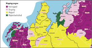
In fall 2010, NISR hired and trained 60 new cartographers to capture geographic boundaries of more than 14,000 villages and landmarks all over the country. They are using GPS devices from Trimble with ArcPad software to update geographic boundaries of the smallest administrative units and to georeference socioeconomic infrastructure, such as schools, health centers, markets, industries, and electricity lines. NISR's GIS team will use ArcGIS for Desktop and ArcGIS for Server to display, query, analyze, and map the census data.

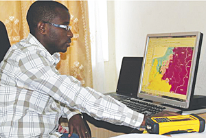
Florent Bigirimana, head of the GIS section of the National Institute of Statistics of Rwanda.
NISR is building its capacity to be able to display multiple data dimensions and enable policy makers to better track the progress of the Economic Development and Poverty Reduction Strategy and the Millennium Development Goals in Rwanda. For instance, census data displayed in maps will assist in the planning of schools, clinics and hospitals, roads, and urban infrastructure. It will reveal the number of orphans and people with disabilities by area and uncover gender disparities in employment and literacy. Moreover, the census results will map infrastructural characteristics, such as the types of dwellings, sources of drinking water, and access to telecommunications and electricity. Finally, census data will be the basis of demographic projections for the future with a spatial distribution.
After the mapping of village boundaries, which is currently being conducted, the NISR staff will interview each household. In November 2010, Esri conducted its third Summer Camp in Rwanda to familiarize secondary school students with GIS. In cooperation with NISR and the National Land Centre, the students anticipated the approach of the real census project. They captured geographic data in small areas, interviewed households, linked the collected data to their geographic location, and presented the results in maps using GIS. Esri and the students afterward shared their experiences with NISR, which was open to and interested in the feedback and new findings on the procedure.
NISR is committed to contribute its part to capacity development in Rwanda and will offer internships to the best GIS students from secondary schools.
For more information, contact NISR (e-mail: info@statistics.gov.rw) or visit statistics.gov.rw. Learn more about Esri Rwanda Ltd. at esri.rw.
Related Podcast
Urban Policy and the Census
Heather MacDonald and Alan Peters, authors of the Esri Press book Urban Policy and the Census, discuss the use of GIS in analyzing demographic trends in urban planning.
Listen to the podcast. [11:00 | 10 MB]
