Russia Introduces E-government
Federal Geoportal Provides Access to Cadastral Information
Highlights
- ArcGIS for Server stores and delivers Russian cadastral data.
- ArcGIS was used to create an automated workflow for the task of converting data.
- Because of GIS, citizens receive real estate documents more quickly and cheaply than before.
Russia is the largest country in the world, covering more than a ninth of the earth's land area. Spanning nine time zones, it is home to 143 million people. Managing the property rights for so many across this vast landscape is a monumental task.
Until a few years ago, Russian property rights, cadastre, and mapping were managed by separate agencies. This meant that while the Russian cadastre was completely mapped and recorded, the data was not consolidated. Changes in legislation to improve public-oriented services led to merging these functions. A federal law was adopted requiring the country's cadastre information to be made accessible to the general public over the Internet in the form of maps. Displaying cadastral information in this form would make the information easier to understand by the people who need it.
Today, legislative and regulatory issues related to cadastral matters are managed by one agency, the Ministry of Economic Development. A public geoportal run by the Federal Service of State Registration Cadastre and Mapping of Russia (Rosreestr) (maps.rosreestr.ru/portal) now stores and delivers Russian cadastral data. Data comes from the Federal Real Estate Cadastre and includes information for registration of rights, receipt of information, and documentation. The geoportal provides the means for anyone to access unclassified data for the entire country quickly and reliably. Using the site, Russian citizens can receive real estate documents more quickly and cheaply than by standing in line at the government agency to request information, then waiting for their documents to be sent via post.
"To date, the system provides an end-to-end solution for those who need information from the state cadastre in electronic format," says Sergey Sapelnikov, deputy director of Rosreestr. "This public cadastral portal is a showcase for state Internet services in the country."
Thousands Use the Automated System
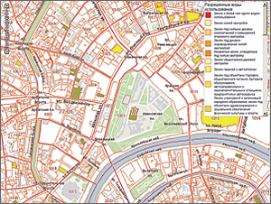
The public cadastre map includes data layers on land parcels; buildings; state, municipal, and city administrative borders; land zone borders; cadastre districts; and the geodetic network. Currently, there are more than 60 million land parcels in the system, and on average, 12,000 users per day use the system.
Development of the portal was awarded to the Federal Cadastral Center, Zemlya, with DATA+, the professional services arm of Esri CIS Limited, Esri's distributor in the Commonwealth of Independent States, serving as a systems integrator. Working with the Ministry of Economic Development, DATA+ began development at the end of 2009 and launched into production status in March 2010. Initial data processing to consolidate all the data took six months, and today the data is upgraded automatically on a daily basis. The portal now contains cadastral data covering 70 percent of Russian territory, and complete coverage for the country is expected by the end of 2011.
From Thousands of Systems to One
Descriptive data for the land plots came from more than 2,500 organizations, using thousands of different systems. The data was first delivered in Extensible Markup Language (XML) format for ease of readability and assembly into one system. None of the data at that point contained spatial information.
Assimilating the spatial information was a huge task: coordinates for the plots were in one of 20,000 different local coordinate systems. Most of this cadastral information was stored in either MapInfo Interchange or GIS ObjectLand format. Esri CIS staff calculated parameters for a system of coordinates for the cadastre, implementing the Gauss-Kr�ger projection with a spheroid of Krassovsky.
The staff created an XML parser to convert the XML documents into geographic objects and features. This made the data easier to manipulate with JavaScript applications. Esri ArcGIS was then used to automate the data process, and the data was stored in a file geodatabase using Oracle RDBMS. ModelBuilder, Python scripts, and C# applications in ArcGIS were used to create an automated workflow for the task of converting the data. Once the data was created and stored, topographic maps were prepared and published.
Viewing 300 Gigabytes of Data Quickly over the Internet
A cluster of servers balances a load composed of 55 gigabytes of vector cadastral data and 250 gigabytes of cached topographic maps. "Since the maps don't change very often, they can be prepared in advance and published by a caching service," says Sapelnikov. "This makes them available for quick viewing over the Internet."
Base topographic map scales that were created for zooming are 1:10,000, 1:50,000, 1:100,000, 1:500,000, and 1:1,000,000. To get an idea of the massive size of the land that is mapped, consider that there are 13,000 map sheets at 1:100,000 scale and 40,000 sheets at 1:50,000 to give complete coverage of the country.
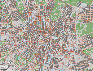
The portal contains background imagery from an ArcGIS Online data service. Using background imagery makes the maps even more recognizable to those who need them. "We have found that this service has the highest precision among similar services that are available," says Sapelnikov.
Cadastre data includes both cadastre divisions and land plots. To date, 65 of the 88 oblasts, which are similar to states, and 50,600,000 land plots have been entered into the system. All Russian territory will be covered by the end of 2011. Plots or properties that are frequently searched, such as in densely populated areas, are optimized for quick viewing. For example, while there are 1,108 cities and towns in Russia, the majority of people live in the capital city of Moscow as well as Saint Petersburg. Consequently, most cadastral searches are performed on these cities.
Online Cadastral Data Leads to More Services
The Ministry of Economic Development, which promotes housing development, greenfield urbanization, and support of future growth, is finding that the portal is speeding up the receipt of necessary legal documents. The time frame for obtaining cadastre certificates and registration of land plots has been greatly reduced by having information consolidated and in a uniform format.
The portal offers several state services—both at no cost and for a fee—through the public cadastre maps. Free public reference services include the ability to find and map the parcel cadastre number and address, land status, parcel area, land-use category, assessed value of the parcel or property, parcel or property statements for reference purposes, and contact information of a local land administration.
Rosreestr also allows members of the community to explore the data in ways they have not been able to do before. Different kinds of thematic maps can be created of the attributes included in the data. For example, maps can be created displaying the cost of the cadastre, estimated mass value for taxation, specific values depending on land category, and the many kinds of land use.
Paid services are legally acknowledged by all authorities. These include the country's legitimate federal cadastre statement, federal property rights register statement, and digital signing. These services went live in spring 2011, and already almost one million statements have been issued.
Web services for Rosreestr have been created using JavaScript, which makes them available for others who want to build their own applications and provide additional services.
For more information, contact Alexei Ushakov, deputy director general, Esri CIS (e-mail: aushakov@esri-cis.ru).

