Can GIS Help Fight the Spread of Malaria?
Zambia Tries Out New Tactic on an Old Opponent
By Emmanuel Chanda, Victor Munyongwe Mukonka, David Mthembu, Mulakwa Kamuliwo, Sarel Coetzer, and Cecilia Jill Shinondo
Highlights
- The DSS harnesses transmission-determining parameters to better evaluate viable options for malaria vector control.
- The ArcGIS software-based system incorporates large datasets, maps, satellite images, and aerial photos to aid in prompt surveillance and policy formulation.
- The system helps identify areas that require specific intervention measures, such as indoor spraying and insecticide-treated nets.
In Zambia, which is situated in southern Africa, malaria remains a major cause of illness and mortality. Its transmission is driven by a complex interaction between the vector (i.e., the mosquito that transmits the disease), host, parasite, and the environment and is governed by different ecological and social determinants. The survival and adaptation of malaria vectors are affected by climate variability, that is, variability in rainfall, temperature, and relative humidity. As a result, even minute spatial variations and temporal inconsistencies in the mosquito population can significantly increase the risk of malaria.
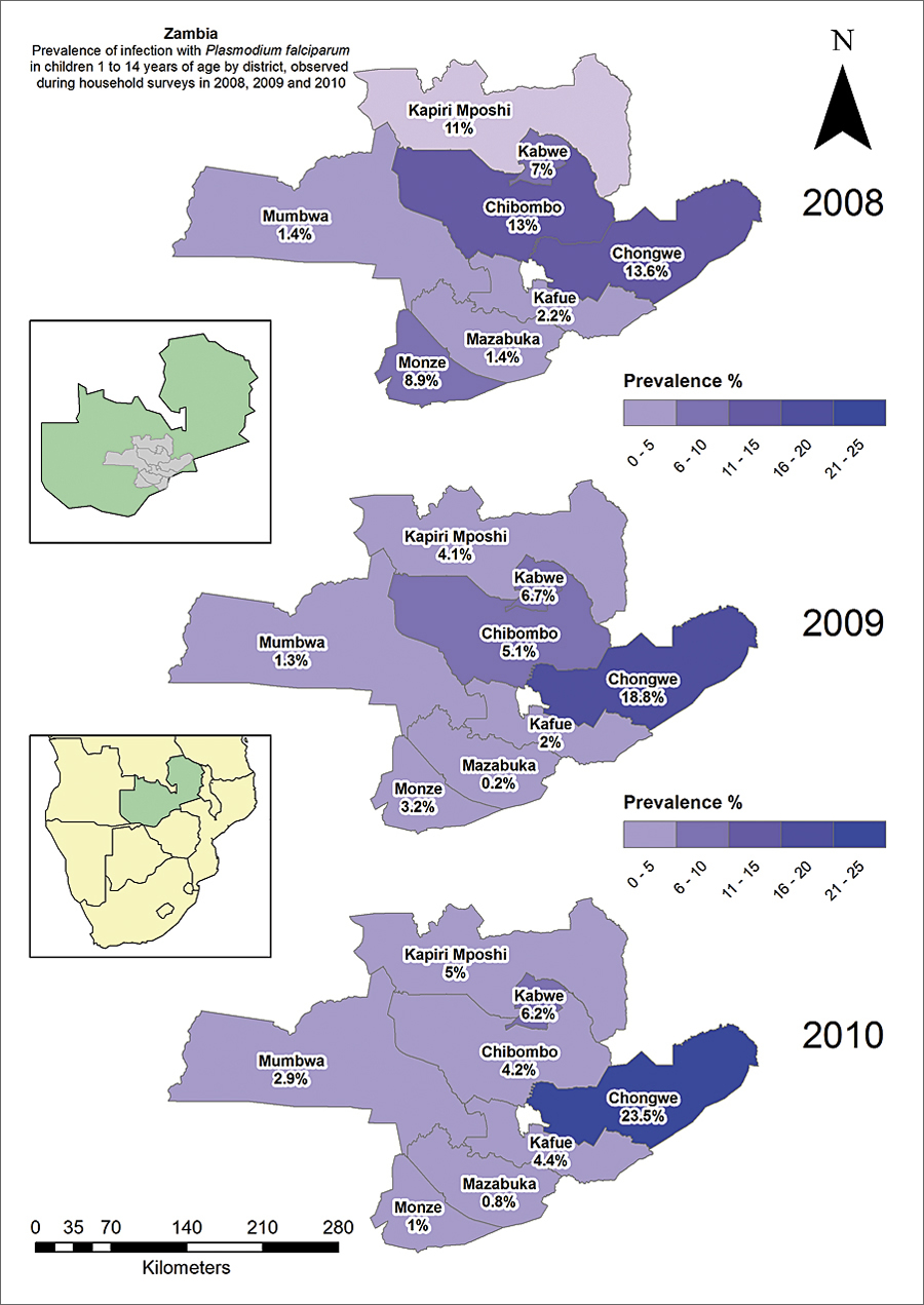
The prevalence of infection with P. falciparum in children 1 to 14 years old as observed during the annual parasitemia surveys from 2008 to 2010 by district.
Zambia has a population of approximately 12 million people, 45 percent of whom are under 15 years of age. Malaria is endemic countrywide, and its transmission occurs throughout the year, with a peak in the rainy season. The disease is the leading cause of morbidity and mortality, accounting for 40 percent of outpatients and 45 percent of hospital admissions, with 47 percent and 50 percent of disease burden, respectively, among pregnant women and children under five years of age. Current trends in the country indicate that malaria is responsible for at least 3 million clinical cases and about 6,000 recorded deaths annually, including up to 40 percent of the under-five deaths and 20 percent of maternal mortality.
Since malaria is not evenly distributed, much effort needs to be expended toward defining the local spatial distribution of the disease before the deployment of vector control intervention measures (i.e., indoor spraying and the distribution of insecticide-treated nets [ITN]) in accordance with World Health Organization (WHO) protocols. Furthermore, insecticide resistance is a growing problem that must be factored into decisions.
However, in resource-constrained environments, monitoring and evaluation are often neither thorough nor regular and tend to lack the important spatial and temporal distribution patterns. Therefore, if transmission-determining parameters are to be harnessed effectively for decision making and objective planning, implementing, monitoring, and evaluating viable options for malaria vector control, those parameters must be well organized, analyzed, and managed in the context of a GIS-based decision support system (DSS).
The usefulness of an ArcGIS software-based DSS for planning and managing control programs is, of course, dependent on the availability of accurate and raw data on malaria transmission-related parameters. The monitoring and evaluation of malaria interventions and an understanding of their true impact on disease burden are essential for measuring the performance of a control program.
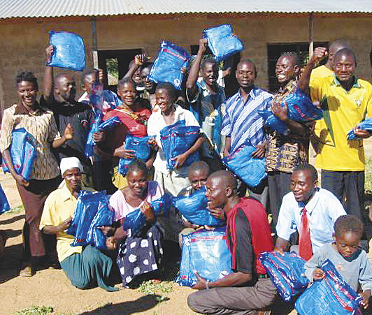
Receiving a shipment of insecticide-treated nets is cause for celebration.
The ability of the DSS to deal with large datasets and incorporate maps, satellite images, and aerial photos increases the feasibility of studying transmission determinants of malaria and has resulted in the prompt availability of data to support surveillance and policy formulation. The epidemiological mapping of high-risk areas of malaria transmission and the insecticide resistance profiles of major vectors has facilitated the recognition of those populations and geographic areas where it is possible to identify the main determinants of malaria morbidity and mortality. The revealed trends and interrelationships have allowed the identification of high-risk areas and facilitated decision making and the rational utilization of limited resources for targeted, high-impact interventions in a cost-effective manner.
Herein is provided a review of data related to the operational use of a GIS-based DSS for optimal deployment, monitoring, and evaluation of entomological interventions for malaria control in Zambia.
Intervention
Indoor residual spraying (IRS) of a variety of insecticides in urban areas is implemented through annual campaigns, with 85 percent coverage of eligible households at the beginning of the peak malaria transmission period. ITNs are deployed in rural areas through antenatal and child clinics, equity programs, community mass distribution, and the commercial sector and strive toward attaining 100 percent coverage in eligible areas.
Stratification
The protozoan parasite Plasmodium falciparum accounts for 98 percent of all malaria infections in the country, causing the severest form of the disease. The national malaria indicator survey for 2010 in children under five years of age shows great spatial variance in the prevalence of infection.
This has resulted in the stratification of the country into three epidemiological categories:
- Type 1 areas with very low transmission and parasite prevalence of less than 1 percent
- Type 2 areas with low transmission and prevalence of less than 10 percent
- Type 3 areas with persistent high transmission and prevalence exceeding 20 percent at peak transmission season

Indoor residual spraying is implemented through annual campaigns with 85 percent coverage at the peak malaria transmission period.
Malaria stratification aids in the development of community-based malaria control programs by accumulating past experiences with and solutions to different factors associated with malaria outbreaks. Stratification can also point to the existing inequalities in resources, allowing for a more equal and homogeneous distribution of available resources.
GIS-Based Sentinel Sites
In this regard, to allow for adaptation of intervention policy, procedures, and methods to better the outcomes, vector control interventions on parasite prevalence in children between 1 and 14 years of age have been monitored through annual malaria surveys for three consecutive years at 19 GIS-based sentinel sites, distributed among nine districts within a 350-kilometer radius of the capital, Lusaka. These sites were established for the continual monitoring and collation of key malaria data, such as parasitemia risk, insecticide resistance profiles in vectors, and impact of interventions on malaria prevalence. The use of the GIS-based DSS has allowed the identification of areas that require specific targeted intervention for impact, either through the use of ITNs or IRS or a combination of both.
Spatial Monitoring of Interventions
The spatial and temporal impact of indoor spraying and insecticide-treated nets on human parasite prevalence and insecticide resistance status in major malaria vectors was monitored. At each sentinel site, household surveys were carried out annually from 2008 to 2010 to measure P. falciparum prevalence in children aged 1 to 14. In Zambia, three nationally representative malaria indicator surveys (MISs) were also conducted in children under five years of age in 2006, 2008, and 2010. The MISs have been used to estimate an empirical high-resolution parasitological risk map in the country and assess the relationship between malaria interventions and parasitemia risk. The spatial impact of interventions and the overall prevalence of infection are as follows:
- Children who lived in a house that had not been sprayed in the past year and did not sleep under a net the night before the survey had a prevalence of infection of 6.8 percent.
- Children who slept under a net but lived in a house that had not been sprayed during the past year had a prevalence of infection of 5.2 percent.
- Children who lived in a house that had been sprayed during the past year but did not sleep under a net had a significantly lower prevalence of infection of 3.2 percent.
- Children who slept under a net in a dwelling that had been sprayed had the lowest risk of infection, with a prevalence of infection of 2.6 percent. Thus, an incremental effect was observed for the combined use of IRS and ITNs.

The mosquito—a major malarial vector.
Spatial Distribution of Insecticide Resistance Profiles
The ArcGIS software-based DSS has been used to collate data on insecticide resistance in Africa. By standard WHO protocol, the spatio-temporal insecticide resistance profiles of major malaria vectors—Anopheles gambiae s.s., An. arabiensis, and An. funestus—were determined at sentinel sites and extended to other regions of the country. More data on the spatial distribution of resistance to five different insecticides has been collected by different partners and collated by the National Malaria Control Programme. Data on suspected and overt resistance to insecticides is being harnessed for vector control. The marked insecticide resistance problem in indoor spraying sites confirms other findings of resistances developing in the wake of extensive vector control. This allows the malaria control program manager to better utilize the limited resources on insecticides to which the malaria vectors are still susceptible. Detection of high resistance levels has facilitated the planning of rational insecticide resistance management strategies and the introduction of alternative non-insecticide-based vector control interventions.
In Zambia, monitoring the impact of vector control through a GIS-based decision support system has revealed a change in the prevalence of infection and vector susceptibility to insecticides and has enabled measurement of spatial heterogeneity of trend or impact. The revealed trends and interrelationships have allowed the identification of areas with reduced parasitemia and increased insecticide resistance, thus demonstrating the impact of resistance on vector control. The GIS-based DSS provides the opportunity for rational policy formulation and the cost-effective utilization of limited resources for enhanced malaria vector control.
Conclusion
Routine surveillance data has proved inadequate for monitoring control programs and is presently being supplemented by parasite prevalence surveys; vector-borne diseases demonstrate decided geographic heterogeneities and therefore require special tools for analysis. With its inherent ability to manage spatial data, GIS provides an exceptional tool for continuous surveillance and a framework for harmonizing surveillance data and parasitemia survey data. At a regional level, the ability of GIS to display data in an intuitively understandable manner has been harnessed to establish a continental database in Africa of the spatial distribution of malaria. The GIS-based DSS has not only streamlined the evidence-based implementation of intervention measures but has also improved the tracking of entomological indicators: species characterization and insecticide resistance status, including parasite prevalence and impact assessment of ITNs and IRS. For resource-constrained malaria-endemic sub-Saharan African countries like Zambia, the need for a GIS-based malaria information system cannot be overemphasized. Until recently, decisions in the malaria control programs were taken on an ad hoc basis driven by limited empirical evidence, undoubtedly resulting in the misdirection of the limited available resources.
For more information, contact Victor Munyongwe Mukonka (e-mail: vmukonka@gmail.com).
About the Authors
Emmanuel Chanda of the National Malaria Control Centre, Ministry of Health, Lusaka, Zambia, coordinated and participated in data collection, analyzed the data, and drafted this article. Victor Munyongwe Mukonka, also of the Ministry of Health, and Mulakwa Kamuliwo of the National Malaria Control Centre, Ministry of Health, were both responsible for management of the project and contributed to the drafting and critical evaluation of the paper article. David Mthembu and Sarel Coetzer of the Malaria Research Programme, Medical Research Council, Durban, South Africa, participated in field survey data collection and mapped the sites. Cecilia Jill Shinondo of the School of Medicine, University of Zambia, contributed to the drafting, review, and critical evaluation of the article.
See also "World Health Decision Makers Should Consider GIS."