New Yellowstone Website Provides Interactive Maps on Volcanic Activity
By Chamois Andersen, Communications and Public Outreach, Wyoming State Geological Survey
Highlights
- The central clearinghouse of information was built with ArcGIS for Server.
- Web mapping includes a mashup of live data feeds, high-resolution digital elevation models, and an array of geologic datasets.
- Via ArcGIS, website users expand their perspective of Yellowstone through layers of information.
The Yellowstone Plateau in northwestern Wyoming has a long geologic history—earthquakes; expanding and retreating glaciers; rising mountains; powerful geothermal explosions; and cataclysmic volcanic eruptions, the most recent of which was the Yellowstone Supervolcano, which erupted 640,000 years ago. Today, the region is a geologic marvel, with one of the largest remaining ecosystems in North America and the world's largest concentration of geysers. More than six million visitors each year travel to Yellowstone to experience its geologic forces. But how can the Wyoming State Geological Survey (WSGS), charged with providing knowledge on geology and energy resources in the state, and with such an incredible testing ground like Yellowstone, better reach a broad audience interested in learning about the park's geologic past? How can the public better appreciate this geologic wonderland? And what innovative web-based tools can be used to showcase the park and provide knowledge on its geologic history, a story so important to the creation of the Greater Yellowstone Ecosystem?
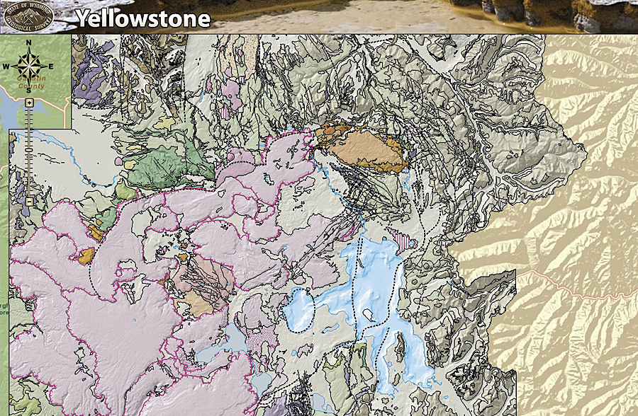
The map illustrates the geology, earthquakes, and hydrothermal areas that make up Yellowstone National Park. The website allows users to view layers ranging from past geologic events to satellite imagery, lake bathymetry, and volcano monitoring equipment in the park.
WSGS created the Yellowstone Geologic GIS Database as an interactive website, providing researchers and students alike with a look into Yellowstone's geologic past and present.
GIS experts and geologists with WSGS and the United States Geological Survey (USGS) collaborated to create a central portal, or clearinghouse, of information on the volcanic eruptions and earthquakes that have created the Yellowstone landscape that continues to evolve today.
This project involved first collecting and compiling data related to Yellowstone's geologic past, including GIS datasets; unpublished bedrock and surficial datasets and maps; and seismic catalogs, field data, hydrologic data, and relevant earth science or cultural datasets. These were provided by a variety of state and federal entities and converted into standardized file types and common databases, including shapefiles and KML files, as well as for a geodatabase. The final step for implementation was to provide the public with access to the data via the WSGS website, which includes multiple downloadable formats for a wide array of users. The GIS applications were created using the ArcGIS for Server Web Application Developer Framework (ADF). This application allows USGS and WSGS staff to update maps, graphs, and charts with near real-time data. Scientists can use the data to create figures and plots of real-time information on dynamic hazardous conditions.
"The past and present geologic activity that continues to shape and form Yellowstone is of great importance and interest to scientists, policy makers, and the public," says Tom Drean, state geologist and director of WSGS. "By creating and updating this interactive website, we are providing past knowledge and current information that can be easily accessed by anyone with an interest in this geologic wonderland," he continues.
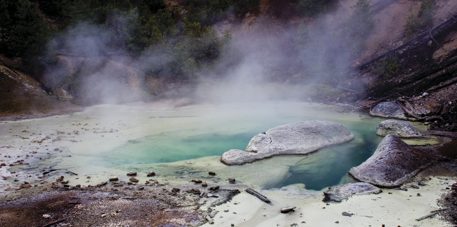
Norris Geyser Basin is the hottest geyser basin in Yellowstone.
Interactive maps illustrate the geology, earthquakes, and hydrothermal areas that make up Yellowstone National Park. The site includes downloadable GIS datasets that allow students and researchers to view layers ranging from past geologic events to satellite imagery, lake bathymetry, and volcano monitoring equipment in the park. The data can also be viewed via Google Earth with 3D visualizations of the area.
WSGS created the website as an educational information portal, representing a major collaboration between WSGS and USGS staff. "This product is a good example of what can be accomplished when agencies cooperate and work toward a common goal," Drean says.
The WSGS Yellowstone Geologic GIS Database website includes the following:
- More than 20 datasets available to download (individually or combined)
- High-resolution lidar and digital elevation models
- Earthquake data (historical and current)
- Geology (bedrock, surface, geothermal, etc.)
- Hydrography (bathymetry of Yellowstone Lake)
- Other information (trails, place-names, boundaries)
- Interactive mapping application
- Live webcams
- USGS live earthquake feed
- Ability to search earthquakes in the park by magnitude and date
- Print map feature
- Media gallery
- High-resolution photos of the park
- USGS videos of the Yellowstone Caldera
The website's main feature is a searchable map of Yellowstone that was created by combining data from a variety of state and federal sources into a single GIS database. The interactive map includes an overlay of colors representing different types and ages of rock. A user can then add various layers to the map, such as topography and imagery (with zoom capability), and even search for earthquakes in the area by typing in a minimum and/or maximum magnitude and the years of interest.
"The flexibility and breadth of information contained on the website allows people to quickly review information that is of greatest interest and use to them," Drean adds.
The present Yellowstone Plateau developed through volcanic cycles spanning 2 million years that included some of the world's largest known eruptions. The Yellowstone region includes three calderas: the first cycle caldera formed 2.1 million years ago during the eruption of the Huckleberry Ridge Tuff; the Henry's Fork Caldera formed 1.3 million years ago near the present location of the town of Island Park; and the Yellowstone Caldera formed 640,000 years ago during the eruption of the Lava Creek Tuff—an event that spread ash over much of the North American continent. Since that time, there have been approximately 80 additional but smaller eruptions, such as lava flows. The youngest of these range from 70,000 to 160,000 years old.
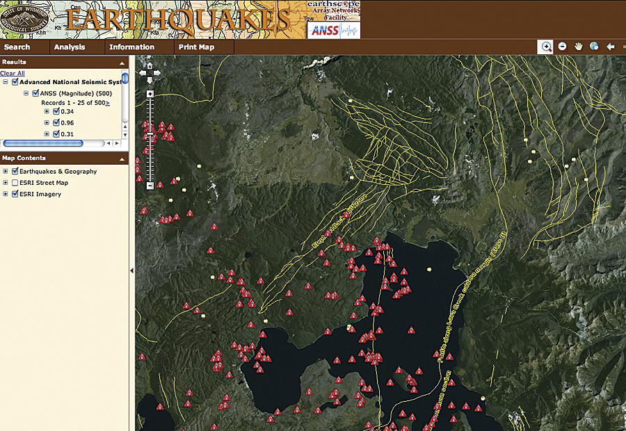
The Wyoming Earthquake Database allows users to search earthquakes in the park by magnitude and date.
"The volcanic events that formed Yellowstone were not the products of many millions of years of geologic change ending many millions of years ago. We are seeing a time scale compressed into only the last 2.1 million years," Drean says. For the Greater Yellowstone Ecosystem, geologists and volcanologists study in detail the latest periods of geologic time, the Pliocene and the Quaternary, covering the last 5 million years out of 4,500 million.
Yellowstone's geologic story also includes earthquakes, such as the Hebgen Lake earthquake of 1959 near West Yellowstone (magnitude 7.5). "This was a major earthquake," says Jacob Lowenstern, scientist in charge of the USGS Yellowstone Volcano Observatory. "It fractured geothermal reservoirs in Yellowstone, creating new geysers and destroying others. Flow rates and temperatures of hundreds of hot springs changed overnight," he said.
Data collection, the use of Esri software and other applications, and the mapping efforts of WSGS are intended to further research on Yellowstone's geologic past and future. "With this web-based tool, we have assembled data from a host of research entities into a single searchable format," Drean says. "This website will be continually updated, providing us with the opportunity to interpret the past and plan for the future of Yellowstone. And if the past gives us a glimpse for what is to come, we know the Yellowstone landscape will continue to change."
About the Author
Chamois Andersen writes and publishes reports for a broad audience concerned about the environment and natural resources. In her current role, she serves as head of Communications and Public Outreach for WSGS. Previously, she worked as a public information officer for the University of Wyoming's Environment and Natural Resources Program, as well as for the California Department of Fish and Game and the Colorado Division of Wildlife.
For more information, contact David Lucke, GIS/IT manager, Wyoming State Geological Survey (e-mail: david.lucke@wyo.gov; tel.: 307-766-2286, ext. 232).