Puget Sound Alliance of Cities Streamlines Access to Location-Based Community Information
Highlights
- Alliance of cities uses ArcGIS to serve community information to 1.5 million constituents in the Puget Sound region of Washington State.
- New data is processed automatically and includes validation, verification, notification, archiving, and updating.
- ArcGIS automation tools streamline data maintenance and reduce ongoing service costs.
Citizens today expect a high level of self-service access to community information across a variety of topics. Much of this information is property based and certainly location based. While most of the information is mappable, not all users have strong map literacy—they may not be image- or map-oriented consumers of information. Constituents are often frustrated when they don't know what government agency to turn to for a particular service.
Powerful tools available in the ArcGIS platform make it easy for cooperating cities to federate their data.
The geography of Washington's Puget Sound region is a dramatic mix of mountains, bays, lakes, and islands. The area is generally known for its verdant green landscapes; fresh seafood; thriving music scene; and, of course, Seattle. In fact, mention Puget Sound to just about anyone, and Seattle is likely to spring to mind. But—just like the dichotomy of mountains and water in the area—bustling Seattle is surrounded by many other cities that have an identity all their own.
Nine of these cities—Bellevue, Bothell, Issaquah, Kenmore, Kirkland, Mercer Island, Sammamish, Snoqualmie, and Woodinville—came together in 2001 to form an interlocal agency called the eCityGov Alliance. The Alliance was created to think, grow, and experiment with business solutions that would replace city-centric web services with seamless, cross-boundary web services.
The Alliance and member cities' goal is to provide constituents with easy-to-find, consistent, web-based services, regardless of the city responsible for providing the service. Since its inception, the Alliance has added 28 cities and agencies as member subscribers to a total of seven Alliance-service-specific web services. The total number of participating municipalities and agencies represents a population of 1.3 million citizens and businesses across a four-county region.
Due to the project's sheer size, both in terms of the number of residents served and the geographic space they were spread across, it quickly became apparent that the Alliance would need to take advantage of technological developments to meet residents' levels of expectation with respect to functionality and the user interface. The goal was to provide constituents with easy-to-find, consistent services, regardless of the city that was responsible for providing the service.
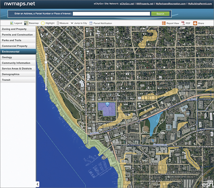
As such, NWMaps.net, one of the aforementioned services, was born. The site, launched the same year that the Alliance was formed, aimed to ease the frustration of residents in 12 Alliance cities—those listed above plus the more recently aligned Renton, Shoreline, and Tukwila. By using this portal, a resident could now access seamless, cross-boundary web services that would provide constituents with easy-to-find answers to their queries, such as which government agency to turn to for a particular service.
Over the years, the eCityGov Alliance has worked to continuously improve its services and portals, making its sites friendlier to users and more efficient. NWMaps.net is no exception. In 2010 and 2011, both the back-office data services and the public-facing user interface of the site were completely rebuilt. The new NWMaps solution architecture is based on ArcGIS for Server.
Bringing a Diversity of Sources into a Common Platform
The eCityGov Alliance and its members are longtime users of ArcGIS. For the revamp, Seattle-based Spatial Development International (SpatialDev), an Esri Partner, was selected to provide a modern solution that was "future proof." The firm was tasked with creating a site that would be both easily extensible to accommodate new information themes and also sustainable with the direction of Esri products.
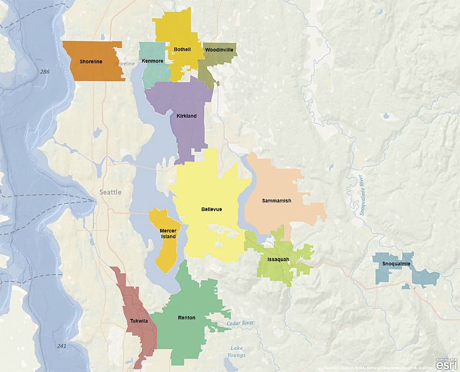
The NWMaps Service Area in the central Puget Sound region of Washington State.
All totaled, the site's member cities collectively spent more than 6,000 hours making the new site happen—work that involved requirements gathering, database design, data preparation, and oversight of the development efforts.
Although they work together on joint projects through the eCityGov Alliance, each city still manages enterprise GIS programs to support individual work programs. This means that each city builds and organizes data differently in response to organizational structure, IT portfolio, and enterprise priorities. To achieve an orderly federation, the revamp project's technical committee designed a standard data model with which to normalize data into a single repository on top of which new map services are built.
With the new design comes a streamlined process to update data for a single city or for a single data layer within a city. New data is simply loaded as a geodatabase to a central server, where an automated process takes up the task of updating. The process includes validation; verification; notification; archiving; updating; and, finally, a refresh of the map services.
Bringing Together Users and the Information They Seek
When user stories were obtained to help revamp the site, it became apparent that users wanted efficient access to information and not necessarily a map. These user needs and expectations required that some functionality be built around the map to extend the experience for the user.
For example, the project team knew that many NWMaps.net users employ one of three things for finding information: an address, a place-name, or—if they are researching specific properties—a parcel number. To accommodate these three modes in a world where search engines have simplified a search to a single box, the site now provides a single search box that can work with any of those three types of information. In addition, users were provided with both a type-ahead suggest feature and a search disambiguation function that enables fuzzy searches and contextual results.
Another newly introduced element of the home page is a quick search feature that allows the user to focus a search based on a variety of themes, such as permitting, parks and recreation, or construction projects. This functionality involved the integration of tabular and spatial data from member city departments, other Alliance applications, agencies outside the Alliance members, and commercial sources. Once a theme has been selected, the site provides a set of contextual results that promotes relevant topics and presets a map display with corresponding layers.
A Refreshed Site Delivers Results
The new site launched during early summer 2011 in parallel with the legacy site and has been well received by eCityGov constituents. In fact, within 60 days, site traffic had increased by more than 400 percent relative to the month prior to the parallel launch.
For more information, contact John Backman, executive director, eCityGov Alliance (e-mail: jbackman@ecitygov.net). Learn more about SpatialDev at www.spatialdev.com.