US Capital's Parkland-to-Population Ratio Ranks High
Washington, DC, Completes Inventory of Federal Lands Within Its City Limits
Highlights
- The District of Columbia now has a centralized inventory of reservations.
- ArcGIS was the best tool for collecting, managing, and maintaining the city's spatial data.
- The data was captured using ArcGIS software's advanced editing tools.
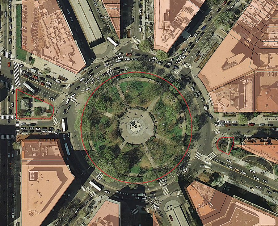
This Dupont Circle is one of the traffic circles and federal parks that was part of Pierre L'Enfant's original plan of the City of Washington.
Andrew Ellicott and Benjamin Banneker began surveying what would become Washington, DC, in 1791. From that time until today, there have been many land acquisitions and transfers between private citizens, the District of Columbia government, and the federal government. These transactions, over the course of 230 years, have established the federal government's land holdings inside Washington, DC. The majority of this public land is controlled and maintained by the United States National Park Service (NPS), is part of its park system, and comprises reservations. Some of the reservations, like Rock Creek Park, encompass thousands of acres, while others are as small as medians in the middle of roads.
The vast system of parks within Washington, DC, helps give the city its unique character. Nearly a quarter of Washington's land area is covered by parks, giving the city a less congested feel and creating an interesting blend of urban and natural landscapes. The city boasts the highest ratio of parkland to population in the country for a city its size: 12.9 acres of parkland per 1,000 residents.
Many of the city's parks were part of Pierre L'Enfant's original plan for the city. L'Enfant envisioned and designed a city with broad, tree-lined avenues and plenty of space dedicated to parks in the form of circles at the intersections of major avenues, squares, and smaller triangle-shaped parks where avenues come together. L'Enfant's vision of an open, light, and airy city, embedded in the surrounding natural environment, has largely been maintained over the centuries.
During the 1800s and early 20th century, as the city expanded beyond the original city boundary of Florida Avenue, planners added to L'Enfant's plan by extending many of the avenues, building new circle parks and smaller community parks, and purchasing large tracts of land to be preserved as parkland. Some of the largest tracts of parkland that were created include Rock Creek Park, Glover Park, Anacostia Park, Haines Point, Fort Dupont Park, and Canal National Historical Park.
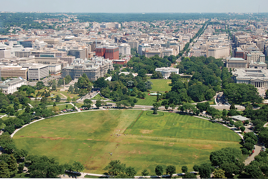
The Ellipse—with the White House and downtown Washington, DC, stretching out behind it—is one of the federal reservations. (Photo by Shutterstock.)
The parks of Washington, DC, help reduce congestion, noise, and air pollution. Many of the parks are large enough that they are able to preserve habitats for some of the native wildlife and help preserve the water quality and ecosystems of the city's rivers and creeks. The parks create areas of recreation for residents of the city, enabling nature hikes, biking, canoeing, public golf courses, the National Zoo, and numerous athletic facilities. Many of the parks also provide opportunities for education and history, especially the circle of Civil War forts that surround the old city, which were converted into parks in the early 20th century. Much of the beauty and quality of life of the city are owed to its numerous parks.
Capturing the Final District Dataset
The City of Washington, DC's Geospatial Information Systems Department (DC GIS) recently undertook the job of researching and then capturing the dimensional information for these parks in its Vector Property Map (VPM) geodatabase. Until this effort, many of the parks were not well documented, or the documentation of their dimensions was spread across numerous source materials. Now that the project is complete, the District of Columbia government has a centralized inventory of all federal lands inside its city limits.
VPM, which the federal parks were incorporated into, is a vector-based geographic information system that contains property information for the district. Much of the property bearing and dimension information in the VPM has been captured based on extensive research of source documents housed in the District of Columbia's Office of the Surveyor and in the Real Property Tax Administration.
The public lands data was the final, significant, uncaptured dataset within the district. There are roughly 1,150 different reservations, both active and inactive, inside Washington, DC. New Light Technologies, an Esri Partner located in Washington, DC, provided a GIS analyst to work with DC GIS to research and produce this dataset.

This triangle park is an example of one of the many smaller parks that are scattered throughout Washington. This park is created by Massachusetts Avenue running diagonally across a grid of north-to-south and east-to-west streets. (Photo by Bill Lescure.)
The data was captured using ArcGIS software's advanced editing and coordinate geometry (COGO) toolsets, using a disconnected ArcSDE database architecture. Esri products were used for the project because DC GIS has been using Esri software for over a decade and has determined that ArcGIS is the best tool for collecting, managing, and maintaining spatial data.
NPS provided additional resource documents to reference during feature capture. When source material from the Survey Office and NPS did not provide enough information to completely collect a feature, other DC GIS data sources were used, including orthophotos; previously captured record, tax, and parcel lots; and right-of-way polygon, planimetric curbline, street centerline, and waterline layers.
For the creation of most of the reservations, it was necessary to weigh different considerations, looking at all the existing source material comprehensively. Sometimes, there was contradicting information that needed to be sorted through from different sources, or there were areas of a reservation without specific length and bearing information. For some of the larger and more complicated reservations, it was necessary to consider hundreds of documents to get the correct lengths and bearings. There is a narrative field in the reservation line layer that contains the source documents and data referenced to build each reservation boundary. If there are ever any questions regarding a reservation's dimensions in the future, this attribute can be used to research all the relevant references.
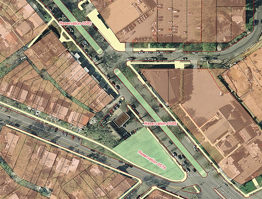
This image shows three reservations whose dimensions were collected with the help of DC GIS planimetric data. The sidewalk data is in yellow, the curb line data is in brown, and the reservations are in green.
Many of the challenges in producing the reservation dataset revolved around making the new reservation line work align with coincident VPM features. In some cases, the line work of an existing lot was the same as the line work for a reservation. This made the collection and placement of the reservation very straightforward. The reservation lot could be created by snapping the new line work to the existing lines and vertices or by copying line work from other existing property lots and city block boundaries. In other cases, lines were created using Esri's COGO toolset. It was possible to use the COGO toolset when there was good documentation that provided lengths and bearings and when the new reservation line work did not conflict with any of the existing coincident lots. The most difficult reservations to capture were those that ran across many city blocks. In these cases, it was often necessary to move and snap existing city blocks and lots to the new line work and, in some cases, rebuild the neighboring lots and city blocks.
Now that this project is complete, there is a single dataset for any person, company, or agency that needs to know the size and location of a reservation in Washington, DC. The detailed dataset that this project produced highlights what public lands are well documented and what portions of the reservations require additional research and surveying. The new dataset improves the daily business processes of the District of Columbia government land management agencies and provides an important data layer for city planners, infrastructure maintenance, land research, business development, community development, public safety operations, the Office of the Surveyor, and the Real Property Tax Administration.
For more information, contact Bill Lescure, GIS coordinator, New Light Technologies (e-mail: bill.lescure@newlighttechnologies.com), or Washington, DC's Office of the Chief Technology Officer, geospatial program (DC GIS) (e-mail: dcgis@dc.gov, website: dcgis.dc.gov).