Spring 2002
Spring 2002 |
|||||||
|
|
|||||||
Transport Authority in Australia Relies on High-Tech Systems to Keep Traffic Flowing
Getting There On Time and Safely with GIS |
|||
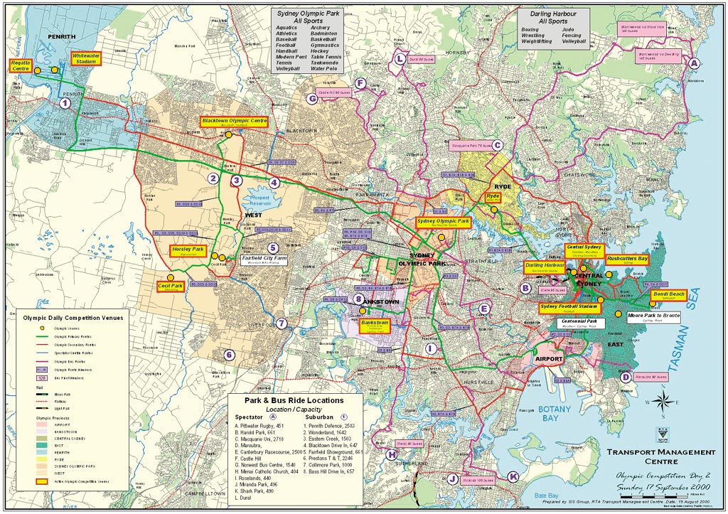
Two fender benders, debris in the fast lane, and your drive time just went south. Traffic jams have become a part of city life. However, "Down Under," in Sydney, Australia, you can be sure that someone is managing these problems to minimize your delays. The New South Wales (NSW) Roads & Traffic Authority (RTA) is the state government authority responsible for managing traffic flow. Traffic controllers monitor and interact with automated systems to control signal timing, availability of traffic lanes, variable message signage (VMS), and other communications. Sydney has mastered the craft of planning and managing a large, widespread road system, and a lot of the credit for its success goes to many GIS implementations. "GIS, in one form or another, has always been here," says a spokesperson at the NSW RTA. The authority manages the operation, maintenance, and enhancement of more than 10,000 miles (17,000 kilometers) of state roads including national highways and nearly 2,000 miles (4,000 kilometers) of regional and local roads in unincorporated areas. It is responsible for driver licensing and vehicle registration and for promoting road safety and traffic management. The RTA also provides support to local governments for managing regional and local roads. A Model for InnovationThe RTA's state-of-the-art Transport Management Centre (TMC) officially opened in September 1999. While not specifically built for the 2000 Olympics, it played a pivotal role in the successful delivery of transport during the games. It continues to provide the same function for other special events including New Year's Eve, Australia Day, City to Surf Fun Run, and various sporting events. The TMC operates 24 hours a day, seven days a week monitoring the NSW road network. The TMC uses a range of high-tech systems integrated with telephone and radio communications to effectively detect and manage incidents and keep commuters supplied with timely, accurate information. Behind the scenes at the TMC, Esri's ArcView, ArcInfo, ArcPad, ArcIMS, and ArcGIS software are helping to get the job done. The TMC uses a range of transportation management applications in incident detection and network maintenance and planning. "When we started using GIS, it was basically to replace the manual mapping function. But now we use GIS to its full extent," says an RTA spokesperson. "We are continually updating the mapping features and locations of intelligent transport devices for our incident management system with Esri software." Integrating Many SystemsTo help manage traffic in the Sydney arterial road network, the RTA, in partnership with SERCO (UK), developed the Central Management Computer System (CMCS). CMCS coordinates the applications available to TMC staff, enabling them to efficiently respond to incidents. CMCS controls variable message signs, variable speed limit signs, closed circuit television cameras, highway advisory radio, and advisory travel time signs and links to the Sydney Coordinated Adaptive Traffic System (SCATS). Operators use PCs running on Windows NT in conjunction with the incident management system server. This enables them to display RTA vector-based graphics with geographic data extracted from ArcInfo and ArcView data sets. To efficiently manage traffic signal timings, TMC uses SCATS. This RTA-developed technology is used in more than 65 cities worldwide. SCATS controls and synchronizes more than 3,000 intersections in NSW. Operating in real time, SCATS constantly adjusts signal timings in response to variations in demand and capacity. A tiered system enables it to automatically adapt itself to changing traffic conditions. Controllers located at each intersection measure traffic density through sensors embedded in the road surface. Regional computers analyze information from up to 128 local controllers and set optimal signal phasing times for an area based on the current traffic conditions. A central computer located at the TMC monitors the operation of each region. Operators at the TMC view the real-time data in CMCS and use Street Finder, an ArcView application, for the search and input of additional information such as the location of an incident. They then use CMCS to analyze the affected area and implement predefined plans to manage the incident. This ability to manage traffic around planned and unforeseen events ensures optimal traffic flow and minimal delays and congestion. In areas of Sydney where traffic follows a distinct pattern according to the time of day, RTA has implemented three tidal flow systems. These optimize the flow of traffic by increasing the number of available lanes in the busier direction. Managed from the TMC, the Electronic Lane Changing System at the Sydney Harbour Bridge coordinates overhead signage, automatic movable medians, and in-pavement lighting to adjust traffic direction in four standard configurations. GIS Tools Developed in the RTATo assist in the location of incidents, Street Finder was developed by the GIS team at TMC. Developed in ArcView and Avenue software, it is a stand-alone application capable of locating a street, an intersection, or suburb/town location in NSW based on vector data. It also has the ability to display raster images (either aerial photos or street directory maps). Access to Business data is also enabled by the dynamic data exchange with a Visual Basic application and hot linking various Web sites. For example, if debris is in the fast lane, by using the hot link tool and clicking on the location, a browser window is opened displaying information on the maintenance call-out crew. The team, using ArcIMS, has also developed an Intranet Street Finder, which is accessed using Internet Explorer (RTA's browser). Within Street Finder (Intranet), there are several buttons that access particular themes of interest: Clearway Towing Routes, Emergency Patrol Routes, Road Train and B Double Routes, and more. Another tool used is Road Flix. Developed within the RTA, it uses a special purpose vehicle equipped with Gipsicam, using a GPS and inertial navigation system to take videos front, back, left, and right. These videos are converted to JPEG terrestrial images at 10-meter intervals along the road network. The images can then be displayed on the ArcView and ArcIMS Street Finder applications. Operators can click on a point in a street and the photo of that area will appear. "We use these images to collect data, and we can get x and y coordinates by clicking on any road attribute in the bottom half of the screen," continues the spokesperson at the NSW RTA. World Class EffortThe 2000 Olympic and Paralympic Games provided Sydney with the greatest traffic and transport challenge in its history. The RTA played a major role in the successful planning, delivery, and management of traffic and transport for the games and worked closely with the Olympic Roads and Transport Authority (ORTA) overseeing the transport of more than six million spectators, 15,000 athletes and officials, and 18,000 media representatives. The RTA's Transport Management Centre was the main command center for the entire Olympic transport operation. The TMC produced daily competition maps that displayed active daily venues; Olympic routes; primary, secondary, and park-and-ride bus locations; bus numbers; and Olympic precincts. Eight sets of 16 Olympic day maps were produced for use in command centers around Sydney along with 150 atlases, each containing 16 Olympic day maps, two park-and-ride maps, a closed-circuit television map, and two variable message sign maps. The TMC also produced strategic tools such as spreadsheets and text. The resources prepared by the TMC were successfully used by Olympic transport organizations, field personnel, and emergency services during the games. For more information, contact Bryan Blake, GIS applications manager, NSW RTA (e-mail: bryan_blake@rta.nsw.gov.au) or Ernie Ott, Esri transportation solutions manager (tel.: 909-793-2853, ext. 1-1984; e-mail: eott@esri.com). |