Spring 2002
Spring 2002 |
|||||||
|
|
|||||||
Tel Shiqmona, a Coastal Site on the Eastern Mediterranean
Marine Archaeology Goes Underwater with GIS |
|||||||||
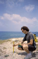
Tel Shiqmona is an Eastern Mediterranean coastal site where human activity is dated from the Late Bronze Age, more than 3,500 years ago. The site is located southwest of the Carmel Cape on the southern tip of Haifa Bay in Israel. The view from Tel Shiqmona on a clear day extends from Atlit to the south to Akko in the north. The elevation and size of the mound, combined with its proximity to the coast, lend to its advantage as a nearshore observation point commanding an extended view in all directions to the sea. However, there are many unanswered questions regarding the reasons for the longevity of Tel Shiqmona as a coastal site of the eastern Mediterranean. Why would the site be located on this coastal perch isolated from the inland trade routes and exposed to the elements of wind and sea? To address this question and others, this study focused specifically on the potential for maritime activity at Tel Shiqmona during the Persian Period (538 B.C.-332 B.C.). The primary goal of this work was to establish the parameters of port capabilities or deficiencies at Tel Shiqmona by examination of the coastal platform and shallow continental shelf using a marine GIS--ArcInfo and ArcView being the primary tools. The second goal was to examine the material ceramic culture of Tel Shiqmona as an indication of maritime trade with coastal sites of the eastern Mediterranean region during the Persian Period. Geostatistical Analyst was an effective tool for analyzing the interpolation of the surface based on point data. This surface was then easily exported to a raster layer to be compared and layered with other features to create the map.
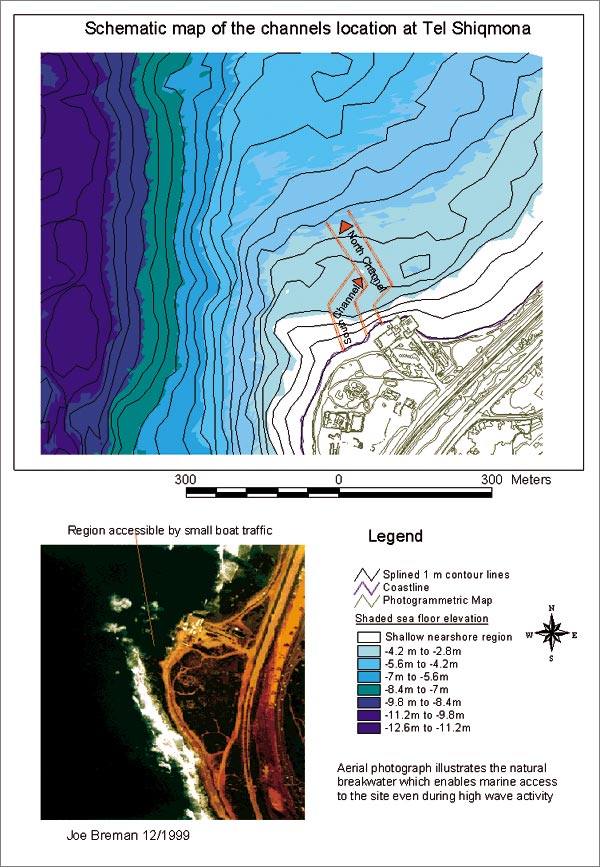
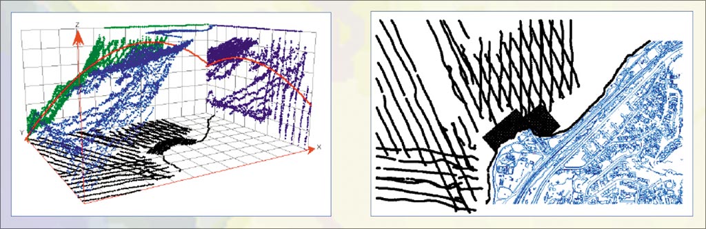
The study of coastal characteristics included an examination of morphological features, tides, winds, currents, sediment transport, and sedimentation. The analysis of sediments at the site was made in comparison with sediments sampled north and south of the region. This study revealed the longshore current present at the site and wave activity that must be considered as limiting factors to coastal access at Tel Shiqmona. As a result of the coastal and marine survey, additional coastal and bathymetric data sets were gathered regarding the bottom type, maximum depth, location of sediments, and the thickness of the sediment layer. The information was integrated into a marine GIS that was utilized for this research to enable an interactive graphic representation of the data collected. Queries and analysis of the interpolated contour lines revealed the inner tidal characteristics of the coastal and nearshore zone. This was achieved using the Spatial Analyst extension of ArcGIS to adjust the base heights of the sea surface layer. Further analysis is being performed in the ArcGIS marine data model. A key advantage of the ArcGIS marine data model (dusk.geo.orst.edu/djl/arcgis) is that it helps users to take full advantage of the most advanced manipulation and analysis capabilities of ArcGIS. This increases the ability to capture the behavior of real-world objects, support the complex relationships that can be built into the geodatabase, and utilize the suite of tools available in the application.
The archaeological and ceramic evidence for maritime trade at Tel Shiqmona was primarily based on the collection of storage jars found in the Persian Period strata at the site. The prior excavations at Tel Shiqmona revealed a large collection of storage jars in the Persian Period strata and indicated a similarity between these sites and other coastal sites of the region during this period. In addition, it was evident that the Persian Period storage jars were maritime in nature. The qualitative analysis of the ceramics included vessels that are widely referred to as storage jars and studied in various assemblages on the Mediterranean coast. Seal impressions and Phoenician inscriptions were also found on vessels of the period and investigated. One of the primary steps in the building of the basemap was the addition of GPS points. Differential GPS points were located on-site and ground-truthed in comparison to their location on the basemap. The GPS coordinates were then used as control points for the coastal and marine survey. GPS data also enabled archaeological benchmarks, such as a fish pool of antiquity, to be located accurately on a map for the first time. Integration of GPS data into the GIS has become simple and seamless using ArcGIS. Integrating the exact location of these control points into ArcGIS enabled this study to attain an accurate reference for other data collected in the field and at sea.
The coastal and marine survey was executed in conjunction with the construction of the GIS. The target of the survey was to complete the area of missing information while providing a ground truthing for the echo sounding points. The depths and substrate type were recorded with the use of marine survey techniques and equipment including scuba, water-jet probe, and air probe. Layers interpolated using ordinary kriging in ArcGISGeostatistical Analyst provide a more interactive and accurate contour map of the coastal and nearshore geomorphology. Similar functionality that has been available in Workstation ArcInfo was achieved in this ArcGIS extension simply by clicking the mouse to render complex trend analysis and kriged layers. This analysis helped to illustrate the regions most easily accessed by vessels of the Persian Period. In this way, a marine GIS was used to incorporate both coastal geomorphology and bathymetrical data. This combined with archaeological findings support the maritime use of the archaeological site and may help to preserve this cultural resource from the impacts of development in the future. This study, interdisciplinary in nature, took into account the historical and geographical review, the survey and examination of coastal geomorphological parameters, and the typological analysis of ceramic evidence of maritime trade at Tel Shiqmona. It was concluded that local maritime trade was a likely practice at this site during the Persian Period and that marine access to the site was possible during calm sea conditions. It is important to note that wide development by the Haifa Marina Authority is proposed near this coastal archaeological site and that this valuable cultural resource is at risk of becoming a part of the building zone for the Haifa Municipal Harbor. The conservation of this cultural resource is a goal shared by members of the Haifa Maritime Museum, the Haifa Municipality GIS Department, Israel Antiquities Authority, and Israel Oceanographic and Limnological Research Ltd. Each of these organizations contributed valuable data to this project. The GIS developed in this work used coastal, marine, and terrestrial coverages as its basis. The data was collected from a differential GPS, echo soundings, a coastal survey, and marine surveys. From this data, layered coverages were produced that answer questions regarding depth, substrate type, and potential navigational routes. The use of ArcGIS and the marine data model to evaluate coastal characteristics and potential maritime trade at a site lacking a recognized harbor or port construction broadens the potential scope of maritime connections and opens new areas for future study. For more information, contact Joe Breman (e-mail: jbreman@esri.com) or visit www.esri.com/marine. This work was developed at the University of Haifa's Maritime Civilization Department and the Geography Department's GIS and Remote Sensing lab. |