Spring 2002
Spring 2002 |
|||||||
|
|
|||||||
In the Aftermath of Hurricane Floyd
North Carolina Flood Insurance Rate Maps Go Digital |
|||||||
|
By Steve Blain, Business Partner Sales-Area Director, Unisys Corporation
The State of North Carolina is no stranger to hurricanes and flooding. Since 1989, there have been 14 federally declared disasters in North Carolina. But the week of September 12, 1999, would see the worst natural disaster in the State's history and set in motion what would become one of the most extensive floodplain mapping projects ever undertaken in the United States. Hurricane Floyd developed from a tropical storm on September 8, 1999. By September 10, Floyd was upgraded to a hurricane by the United States National Weather Service and had strengthened to a category 4 as it reached the Bahamas and tracked north on its way to North Carolina. Hurricane warnings were issued for the Carolina coastlines on September 14 and an estimated two million people were evacuated as Floyd drew closer. This was the largest evacuation is U.S. history. After being downgraded to a category 2 hurricane, Floyd made landfall at Cape Fear, North Carolina, on September 16 and produced a flood disaster of immense proportions. The drenching storm dumped 15 to 20 inches of rain on North Carolina's coastal plain--two weeks after an eight-inch rainfall from Hurricane Dennis--and the effects were devastating. Floodwaters damaged more than 54,000 homes and destroyed or left uninhabitable another 16,000, most of them without flood insurance. More than 48,000 people were in shelters as rivers and creeks crested well above flood stages resulting in the police and military performing 1,400 swift-water evacuations. Fifty-one people lost their lives, and damages from the hurricane alone reached $3.5 billion. Hurricane Floyd had just revealed the flood-hazard data and map limitations in the State. A Hard Look at the State's Flood Insurance Rate MapsA review by the State revealed that 75 percent of the State's Flood Insurance Rate Maps (FIRMs) were at least five years old and that 55 percent were at least 10 years old. These maps are traditionally paper based and used by local floodplain managers to determine where flooding is likely to occur. The Federal Emergency Management Agency (FEMA) is chartered with producing and updating these FIRMs; however, FEMA's mapping budget was finite. On average, North Carolina received only one updated flood study for one county per year, and there are 100 counties in the State. With many of the counties and communities lacking the necessary resources to take on the responsibility themselves, and the State's belief that accurate flood hazard information was crucial to protect lives and property, the State acted.
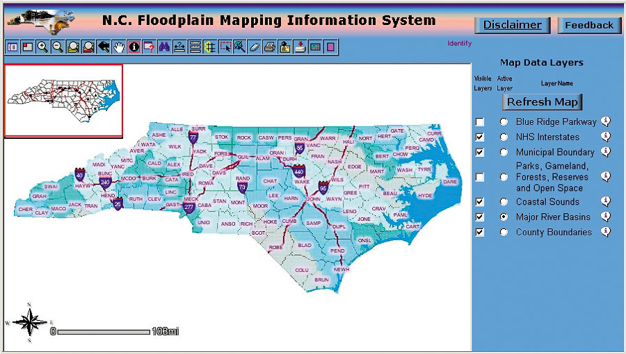
On September 15, 2000, the first anniversary of the Hurricane Floyd disaster, FEMA and the State of North Carolina announced a historic agreement to develop a model program to maintain accurate flood hazard information for the State. Working with FEMA, North Carolina would become the first Cooperating Technical State and assume the primary ownership and responsibility of the FIRMs for all North Carolina communities as part of the National Flood Insurance Program. The Information Resource Management Commission (IRMC) was formed by the State's legislature to assist the State in making key technology decisions involving major projects. "The agencies have to go through a project certification process," says Stan Jenkins, senior enterprise architect for the IRMC office. "Our group conducts the technological architectural reviews of these projects and recommends to the IRMC approval or disapproval of the architecture. Additionally, we provide a quality assurance program methodology to the project, which significantly enhances the probability of its success." The Selected SystemThe system architecture selected by the State, and approved by the IRMC, was a Unisys e-@ction Enterprise Server ES7000 16 processor system. The system was configured as a dual domain environment running the Microsoft Windows 2000 Datacenter Server operating system and the Microsoft SQL Server 2000 database. There is a test domain and a Web domain. The test domain is used to certify and qualify the data, such as county submittals, by performing an extensive upload and quality control process. Once the data passes these stringent tests, it is posted to the Web domain on the system where it is available to the public and various agencies for analysis, planning, and emergency response purposes. Unisys also worked closely with EMC, which provided the 7-terabyte CLARiiON FC4700 Disk storage system. Esri's ArcIMS was selected as the core software technology, providing map services over the state's wide area network and Internet to more than 40 government agencies as well as to counties, State municipalities, Businesses, and the general public. ArcIMS mapping services access data from a six-terabyte Microsoft SQL Server 2000 database using ArcSDE. Web services also support data downloads from a preconfigured FTP data source. ArcGIS clients (ArcInfo) are used, along with custom upload tools, to support data loading and administration. Floodplain Mapping ProgramThis Floodplain Mapping Program entails
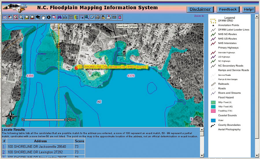
In August 2000, the North Carolina General Assembly allocated $23 million to the Floodplain Mapping Program, and FEMA contributed an additional $6 million as well as engineering, mapping, and program management services. The program was divided into three phases with Phase 1 consisting of the State's six eastern river basins, which comprise 50 percent of the State. One of the first contracts awarded went to Watershed Concepts, an Esri Business Partner that focuses entirely on floodplain analysis, to conduct the hazard analysis and produce the updated DFIRMs for four of the river basins. To determine the land elevation data, the program is utilizing Light Detection and Ranging (LIDAR) technology. This is a process where laser beams are shot to the ground as a plane flies over the targeted basin. By measuring the time it takes for the beams to hit the ground and return, one is able to calculate elevation and catalog this information with its respective GPS coordinates. "It generates a very large volume of data, and we are working with multiple terabytes of information in this project," says Tim Johnson, acting director of the Center for Geographic Information and Analysis, IT component lead of the Floodplain Mapping Program. "We are working closely with FEMA to provide them with a model that other states could follow." North Carolina communities and citizens will benefit from accurate information, enabling property owners to make sound site planning and design decisions when rebuilding after flooding disasters, building new structures and infrastructure, and when retrofitting existing structures. Additionally, the State expects a dramatic reduction in long-term flood losses as a result of updated flood hazard data for floodplain management. For more information, contact Steve Blain (tel.: 310-284-9621, e-mail: steve.blain@unisys.com) or Scott Arbogast (e-mail: scott.arbogast@unisys.com) of Unisys Corporation, or visit the North Carolina Web site (www.ncfloodmaps.com). |