Spring 2004
Spring 2004 |
|||||||
|
|
|||||||
Geography Matters in Business Applications
For Coinstar, GIS Provides Common Framework for Information Integration, Analysis, and Sharing |
|||||
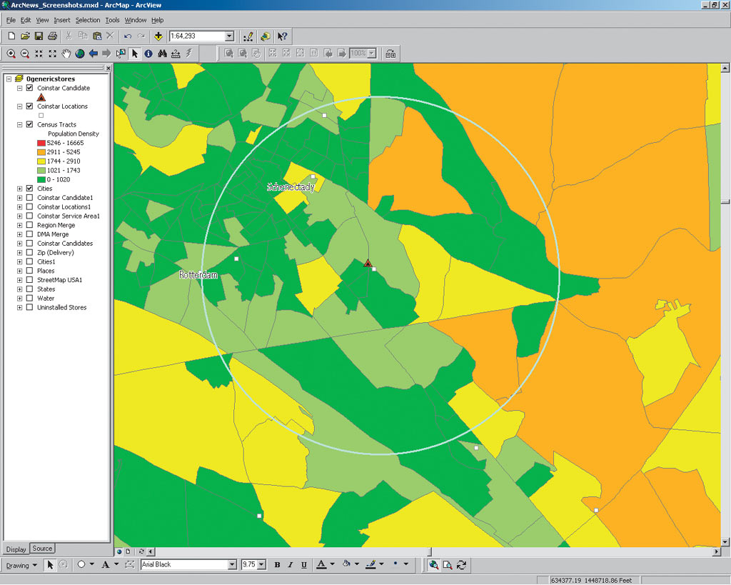
Who would have thought a lucrative, successful business could be forged from the pennies, nickels, dimes, and quarters lurking throughout the corners of most households, automobiles, and other locations? Well, that's exactly what Coinstar has done with its self-service coin counting machines located at the front entrances of supermarkets nationwide. The Coinstar machines count a person's accumulated coins and dispense a voucher that can be exchanged in the store for cash or groceries. Based in Bellevue, Washington, Coinstar, Inc., today has a network of more than 10,500 machines currently available to about 165 million consumers in 48 states and the District of Columbia as well as Canada and the United Kingdom. Coinstar's record profits and growth demonstrate the company's success and innovation. As easy as it may seem, placing Coinstar machines at the right store location is extremely complex and is of vital importance. Maximizing the best location for meeting consumer needs is the difference between business success and failure. And as the Coinstar enterprise grows—from hundreds to thousands of locations—finding the best place for a new location and evaluating how that new location impacts the rest of the existing enterprise becomes an even more arduous task. Coinstar turned to database technology for collating reams of information that continually swelled with each new store. These databases were used to answer a number of questions regarding new store site selection questions. But the company still did not have an effective means for separate department officials—from marketing to operations to sales—to integrate, share, and leverage each other's data and work experience knowledge. Several years ago Coinstar began to search for a solution that would better integrate information and allow easy access across the enterprise. After searching high and low for a solution, Coinstar recognized how GIS could meet these needs, provide powerful mapping, and provide a technology platform for growth into the future. The company began its first use of GIS via desktop software for basic, informative maps. What has resulted is a myriad of GIS applications used throughout the organization. "Today we have a range of applications that has been applied to several different areas of the company," says John Chestnut, GIS specialist at Coinstar. "GIS has proven itself over and over again as a technology tool for many facets of our business. It's more than just computer mapping. It's real data integration, analysis, and visualization." From Desktop to the EnterpriseCoinstar went through an extensive evaluation process before selecting Esri software. Different software packages were evaluated with non-GIS personnel in a number of departments to assess software ease of use, learning curve, Microsoft's ODBC compatibility, network access, cost, and other factors. Interviews with existing database users were also performed to get a firsthand understanding of the separate technologies. When the process was complete, Coinstar selected Esri software because of its scalability, flexibility, open standards, and other features. Today the company uses ArcGIS Desktop (ArcView) and the ArcGIS Spatial Analyst and ArcGIS Network Analyst extensions. The hardware platform consists of Dell Optiplex GX240 P4-2 GHz and Dell Optiplex GX110 PIII-866 MHz using a Windows 2000 operating system. The company uses SQL Server for its database management system with Microsoft Access software. In addition, the company uses Esri Business Information Solutions (Esri BIS) Portfolio software with Esri BIS data. GIS Business ApplicationsGIS is used for a vast array of business applications. Prior to GIS, maps were not used across the enterprise for these many different applications. The few maps that were used were hand drawn on paper and contained handwritten notes and annotations. The maps could not be shared throughout the enterprise, and updating maps with new information was time-consuming and often inaccurate.
Coinstar today has two GIS staff members who perform analyses for several departments across the enterprise including marketing research and analysis, retail account development (sales), coin services, field operations, installations, and finance. Using GIS, Coinstar links separate databases from these various departments that manage data sets for stores, customers, market demographics, and more. Marketers, for instance, use ArcGIS Desktop and Esri BIS Portfolio and demographic data from Esri BIS to carry out site performance modeling and develop a performance predictor for various grocery store sites across the United States. This helps ensure constant high-level performance for existing sites. It also helps them understand what variables make up existing market areas and where potential new markets exist. Thus, marketers know exactly where to carry out specific marketing campaigns such as direct mail. There is a host of logistical planning applications better served through fact-based maps. Using ArcGIS Desktop and ArcGIS Network Analyst, the company can more quickly and accurately plan and route coin pickups. In addition, service technicians can better deploy resources for installing new machines using site location maps. Sales staff can use demographic and customer-driven maps from ArcGIS Desktop and ArcGIS Spatial Analyst software to target new customers as well as show other Coinstar staff why certain locations should be pinpointed for new sales efforts. These maps can also be used to show potential clients why and how it makes sense to add a Coinstar machine to their store. Perhaps the most profound use of GIS data and maps is one of the most basic: providing a common point of reference in the form of a map during meetings where various stakeholders evaluate the merits of a potential new location. Sales, marketing, service, and other professionals come together to share and discuss the many data sets and variables for evaluating a potential new client: Does the area contain demographic characteristics similar to successful sites? Is it within a service technician location, or does a new location need to be added? How will a new site impact routing of coin pickups? Will the new site impact sales at an existing site? The GIS map provides many layers of pertinent data overlaid and used as a reference point for communication. Separate departments have a common framework for collaboration. For more information, contact John Chestnut, GIS specialist, Coinstar, Inc. (tel.: 425-943-8233; e-mail: jchestnut@coinstar.com). |