Spring 2005
Spring 2005 |
|||||||
|
|
|||||||
Consultants, Brokers, Developers Can Now Get a Clearer Picture
In Texas, the Greater Fort Bend Economic Development Council Helps Businesses Develop Sites, Relocate, and Expand With GIS |
|||||
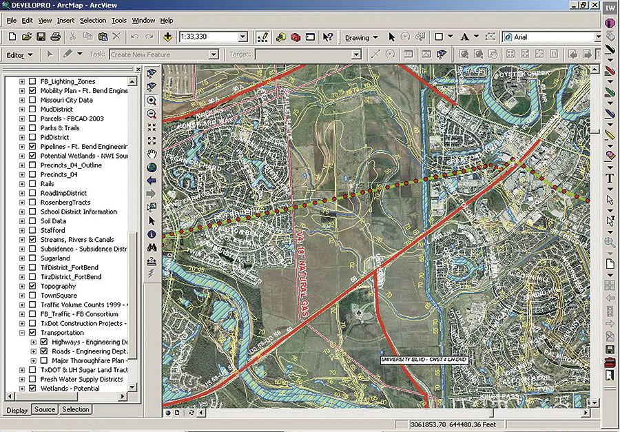
For more than 15 years, Fort Bend County, Texas, has been in the top 20 counties in the United States for economic excellence (99th percentile for job and population growth). It's because this county has something to offer everyone—affordable housing, high quality of life, ample recreational opportunities, excellent school districts, and jobs. The highly educated workforce (40 percent of adults have bachelor's degrees or greater educational attainment) has attracted global corporations seeking ethnic diversity. The subtropical climate allows outdoor activities year-round; it's no wonder Fort Bend County hosts 21 golf facilities with 450 holes of golf, making it one of the highest per capita golf areas in the nation. The Fort Bend markets are thriving. In less than five years, Fort Bend has added approximately 9.2 million square feet in office, industrial, and retail space. To continue promoting economic vitality and quality development in Fort Bend County, the Greater Fort Bend Economic Development Council (EDC), a public–private partnership, was established in 1986. This is the council's mission, and as a result, corporations requiring excellence and diversity in their workforce are finding a home in Fort Bend County. Global corporations, such as Baker Petrolite, Champion Technologies, Fluor Corporation, Frito-Lay, Input/Output, Nalco, Sabic Americas, Schlumberger Technology, Suntron, Tadarin Microwave Networks, Texas Instruments, and Unocal are thriving in this diverse environment. With 5 to 6 percent annual growth and rapid progress such as this come difficulties in getting information out to those who need it on a timely basis. The council had been using traditional paper process technology to respond to site location, demographic, and available space inquiries. The council needed a better way to assist developers while continuing to plan for quality development, as well as find a better solution for the input, storage, retrieval, and delivery of this information. The council was intrigued with GIS and saw how the technology could bring it benefits. Along with its business partner LJA Engineering (Austin, Texas), the council created an economic development tool—DEVELOPRO—based on ArcGIS Business Analyst. This tool is a customized application based on an easy-to-use menu system that is outfitted with a 72-inch, touch sensitive "smart" screen connected to a Dell laptop computer system. Using ArcGIS Business Analyst along with DEVELOPRO and the touch screen, GIS is easy to use by people who may not be familiar with the technology. Research time for site identification and development, fatal flaw analysis, and demographic research is greatly reduced. Site consultants, brokers, corporate real estate executives, and developers can now do site selection and feasibility research with little assistance from council staff.
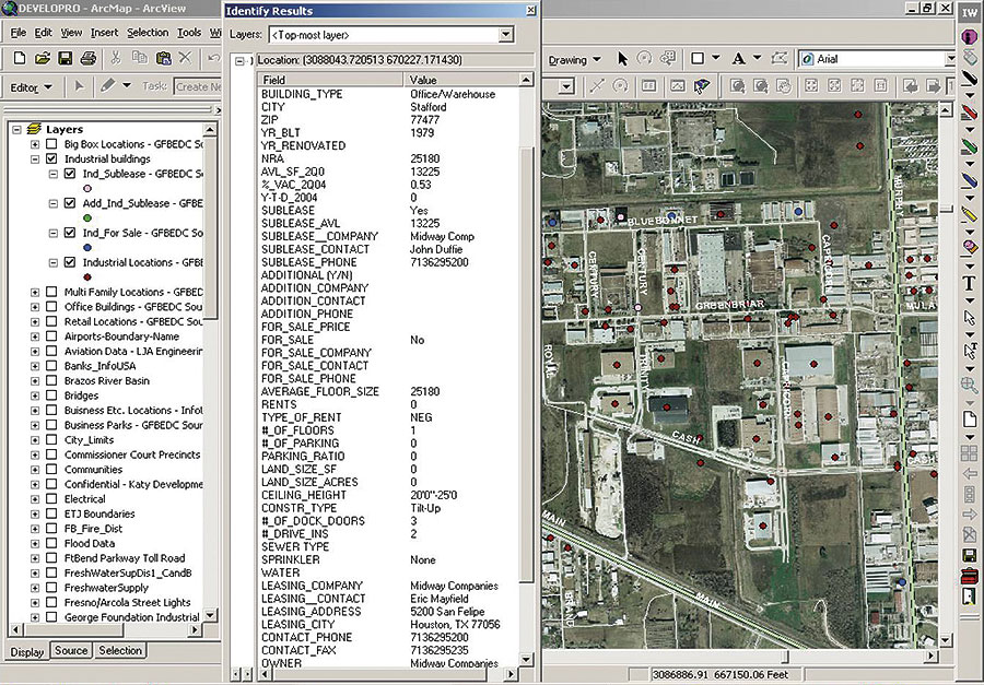
The data used is based on a digitized aerial photograph of the county with more than 100 layers of additional information, including roads, topography, county mobility plans, municipality utility districts, and demographics. The council has included data layers for retail "big box" and office and industrial buildings availability. Sharing of this data is now more efficient and cost-effective for the government agencies, the County GIS Consortium, and the private sector. ArcGIS Business Analyst has made it easy for users in these different organizations to share maps and data. New layers of information are added continuously, and cost sharing has reduced the basemap burden on individual participants. "Without the GIS Consortium and our partner, LJA Engineering, this exceptional project could have never become a reality," says Herb Appel, president of the Greater Fort Bend Economic Development Council. "Now, because of this cooperative effort, site consultants, brokers, users, and developers can now identify potential sites, research all infrastructure availability, and narrow their search criteria in one session with a staff member using the GIS system. This has the potential to revolutionize the way the entire economic development industry does business. We believe the process of identifying and utilizing shared information between the units of government, the Fort Bend EDC, and the private sector will lead to increased revenues and decreased expenses for all concerned." Now, a client or broker looking for office space in the county sets up an appointment with the council and sits down with a technician to search office space. ArcGIS Business Analyst is queried with the specified project parameters through the customized menus that make up DEVELOPRO. Information, such as address, name of building, rental rate, size, available space, amenities, and broker information, is instantly accessible. All the office buildings that fit these parameters are shown on the aerial photo. By touching one of the location symbols on the touch screen, the building specifics will appear along with a link to a photograph of the building. In less than one hour, the broker or client can leave the council's office with a color printout or digital file of each building that meets its needs, as well as complete demographic and tax information for the site. This analysis can be used for the county's retail, industrial, and raw land. The client or broker can identify potential sites, research infrastructure availability, and narrow its site search. "Throughout the years, we have gathered every piece of information that we could get hold of," says George Culver, GIS specialist, Greater Fort Bend Economic Development Council, "essentially creating a comprehensive library of Fort Bend County. Data creation and sources ranged from previously formatted GIS data and hard-copy maps to mapping personal knowledge of county activities and resources. Working with the people within the county (county officials, brokers, developers, and special interest groups), we have created a central data location that will answer any question that may arise about Fort Bend County." Research and Development ParkIn an effort to strategically plan for future development of the remaining commercial property in the cities of Sugar Land and Missouri City, the council and the cities retained Angelou Economics (Austin, Texas) to perform a market and economic study, a target industry analysis, and site assessments for seven developable sites. Angelou Economics' engineering and architectural partner M+W Zander (Stuttgart, Germany) used the council's staff and DEVELOPRO to analyze each site in order to determine site development alternatives. The study led the council to focus on one of the sites analyzed for a recommended "future energy" research and development park. Following the analysis, the council and Cullen School of Engineering at the University of Houston, Texas, initiated an effort to create the Texas Energy Center (TxEC), a cluster of research organizations, educational institutions, and energy companies assembling to find solutions to U.S. energy concerns. The council used DEVELOPRO to present the site of the TxEC future home to the developers and the Gas Technology Institute. This presentation was also given to the Research Partnership to Secure Energy for America (RPSEA), which focuses on ultra deepwater petroleum development and unconventional resources for energy. This effort was successful, and RPSEA and the Texas Energy Center are located in Fort Bend County today. The council is now more efficient and effective in attracting new business, industry, and development to Fort Bend County. The council believes this innovation has the potential to revolutionize the way the economic development practitioner does business. Says Appel, "We now know that the process of identifying and utilizing shared information between the units of government, the economic developer, and the private sector will lead to reduced time and effort, increased revenues, and decreased expenses for all concerned." Site specific research work that used to take up to three weeks to complete can now be accomplished in a matter of minutes. The system provides them with a more extensive understanding of a site's attributes than they have ever received from economic development groups. Appel continues, "The next generation system now under development will be Web-based and will also employ ArcGIS Business Analyst software to incorporate instant site specific demographics." The Greater Fort Bend Economic Development Council has assisted in more than 110 business relocations and expansions into Fort Bend County. This has resulted in increased tax valuations of more than 10 percent in each of the last three years and 14,700 new jobs. Based on this project, the council was selected as the recipient of the 2003 Global Innovator's Award given each year by CoreNet Global, the world's premier professional association for corporate real estate leaders. From the finalists, five winners were chosen: Ford Land, the Fort Bend Economic Development Council, Sprint, Toyota, and the U.S. Army. The council won in the Innovations by Communities/Economic Development Organizations category with DEVELOPRO. For more information, contact Herb Appel, president, Greater Fort Bend Economic Development Council (e-mail: happel@fortbendcounty.org). |