Spring 2006
Spring 2006 |
|||||||
|
|
|||||||
Modeling Archaeological Sensitivity in Vermont with GIS |
|||||
|
Over the past several decades, significant improvements in processing capacity and GIS software sophistication have encouraged the development and use of computer-based models of archaeological sensitivity to augment traditional research approaches and field investigations. The Vermont Archaeological Sensitivity Model (VTASM), a GIS-based framework for simulating archaeological sensitivity statewide, is a recent example of this trend.
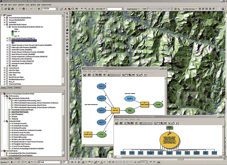
A key element of archaeological research and cultural resources management is estimating the relative potential for buried cultural deposits in specific geographic areas. Reliable estimates of archaeological potential or sensitivity are necessary for the implementation of effective sampling strategies. Quality assessments of relative archaeological potential are also useful planning tools, facilitating the avoidance of potentially significant cultural resources and minimizing the costs of regulatory compliance associated with development. VTASM emerged out of an interest expressed by the Vermont Division of Historic Preservation (DHP) and the Vermont Agency of Transportation (VTrans) for a statewide GIS map showing relative potential for subsurface prehistoric archaeological deposits. For several years, DHP has been involved in GIS modeling of archaeological sensitivity at the watershed level, utilizing environmental criteria specified on a field assessment scoring form used by the DHP and consulting archaeologists. These criteria were adapted from a paper-based environmental stratification model developed in 1989 by researchers from the University of Maine at Farmington Archaeology Research Center (UMFARC) for a major pipeline project. Most of the criteria highlight proximity to water and landform features that would have been central to prehistoric travel and subsistence strategies. VTASM is an integrated GIS solution for modeling archaeological sensitivity in Vermont based on the well-established DHP environmental criteria. Structured by the new ArcGIS (ArcInfo) geoprocessing framework, VTASM provides a suite of tools and a custom data management system designed to allow on-the-fly modification of data inputs and analytical parameters, facilitating the evaluation of different scenarios in a scientifically repeatable manner. VTASM was developed by a team of researchers from three organizations: Esri Business Partner Earth Analytic, Inc.; UMFARC; and the University of Vermont Consulting Archaeology Program (UVMCAP). Project funding was provided by the Vermont Agency of Transportation and the Vermont Division for Historic Preservation. Earth Analytic, Inc., served as the GIS technical lead for the development and implementation of VTASM. A GIS steering committee composed of archaeologists from a variety of state and federal agencies and institutions provided oversight and feedback. VTASM is implemented with ArcInfo, ArcGIS Spatial Analyst, and ArcGIS 3D Analyst, taking full advantage of ArcGIS ModelBuilder software and the ArcGIS application ArcToolbox. At the core of the system is a functionally and thematically organized directory structure for GIS data, documents developed with the ArcInfo application ArcMap, toolboxes, exported maps, and documentation. The VTASM user interface is an ArcInfo document that points to all required model inputs and a custom toolbox containing about 20 ArcGIS models: flowchart-like representations of sequences of GIS data management and analysis processes. The VTASM toolbox is subdivided into two toolsets: one for data preprocessing and one for statewide analysis. Geoprocessing environment settings are configured at the level of the toolbox, simplifying the process of changing default settings (workspace and scratch space locations, output extent, mask, and cell resolution) for the entire statewide model.
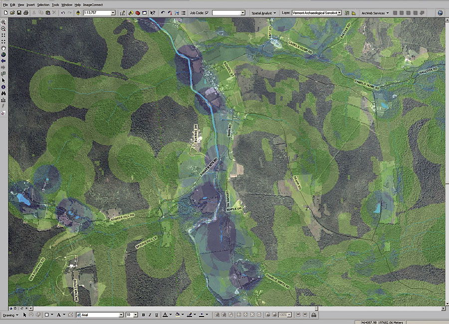
The project database includes statewide wetland and hydrological datasets, including the high-resolution (1:5,000) Vermont Hydrographic Dataset (VHD), as well as Soil Survey Geographic (SSURGO) data for most of the state. A notable data limitation is the absence of 10-meter digital elevation models (DEMs) for the state, although the model does incorporate lidar-based 8-meter DEMs for a subset of the project area. Five major preprocessing models prepare specific datasets for use in the statewide model: hydrological nodes (confluence and terminus points, collectively referred to as hydronodes), lidar, floodplain soils, streams, and wetlands. For example, one of these models draws on outputs from four watershed-specific hydronode preprocessing models applied to each of the 17 Vermont watersheds (USGS HUC8). Another preprocessing model converts multiple CAD point datasets into a triangular irregular network (TIN), then converts the TIN into an eight-meter resolution raster. The statewide analysis toolset consists of 11 environmental component models (ECMs) that are combined in a composite archaeological sensitivity model. Each ECM yields a statewide 10-meter resolution raster with binary cell values. In each raster, cells meeting model criteria are assigned a value of one and remaining cells get values of zero. Six ECM models assign archaeological sensitivity scores to buffer zones associated with specific water-related features: drainages, water bodies, wetlands, stream confluences, stream-water body confluences, heads of draws, and waterfalls. For example, the Drainage Proximity ECM generates a raster buffer zone of 180 meters around the preprocessed statewide VHD drainages. All cells within 180 meters of streams are assigned a value of one in the output raster. Given the large size of input datasets, the use of raster-based buffering methods (integer-based reclassifications of Euclidean distance surfaces) greatly reduced CPU requirements and time relative to vector-based buffer operations. The five remaining ECMs assign sensitivity scores to relict lakes, kame terraces, glacial outwash deposits, floodplains, and areas of level terrain. One example is the "Paleo" Lake ECM, which creates a statewide raster of all areas covered by soils (Vermont Center for Geographic Information/SSURGO) formed in late glacial periods, just prior to the arrival of Paleo-Indians. "Paleo" lake parent materials are assigned a value of one, and all other areas are assigned a value of zero. The final archaeological sensitivity model combines the results of the 12 component models using a weighted sum function. For the preliminary release of the VTASM, all ECMs were assigned equal weights by default. The resulting statewide raster has values ranging from zero to nine, representing the number of overlapping environmental criteria for each cell. While the preliminary results of the VTASM analysis are encouraging given that the model has strong predictive value, project stakeholders recognize that, in many cases, computer modeling is not a substitute for firsthand, field-based archaeological assessments. The project has provided tools for modeling and visualizing reasonable proxies of prehistoric archaeological sensitivity that can be used in concert with traditional archaeological approaches. The Vermont Agency of Transportation is the major sponsor of this work. For more information, contact Ellie Cowie, UMFARC (e-mail: ecowie@maine.edu); John Crock, UVMCAP (e-mail: jcrock@zoo.uvm.edu); Giovanna Peebles, Vermont DHP (e-mail: Giovanna.Peebles@state.vt.us); Duncan Wilkie, VTrans (Duncan.Wilkie@state.vt.us); or Wetherbee Dorshow, Earth Analytic, Inc. (e-mail: wdorshow@earthanalytic.com). |