Spring 2006
Spring 2006 |
|||||||
|
|
|||||||
Service Organization Catalogs and Maps Linguistic Data
Pinpointing the Languages of the World with GIS |
|||||
|
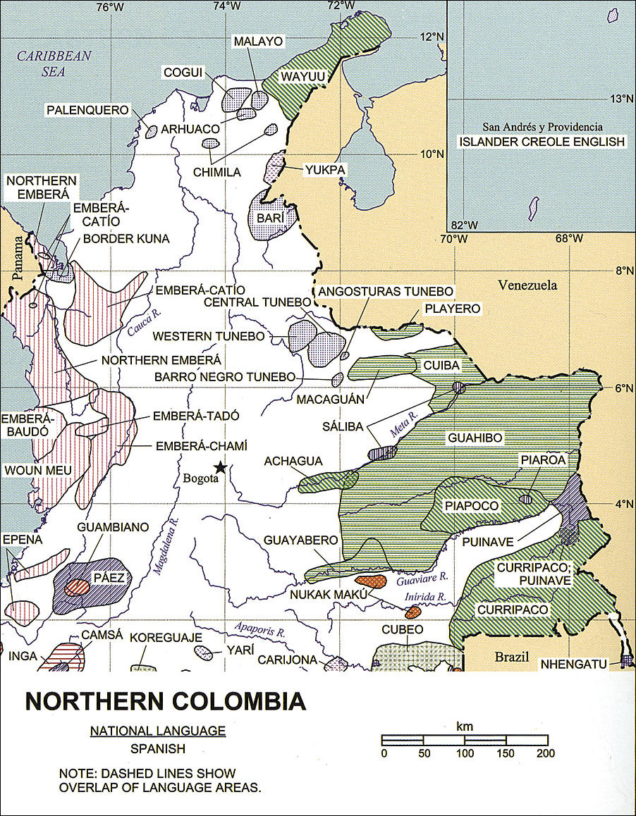
People with language interests, who study the vicissitudes of languages as new ones are cataloged and others fade away, need information about the locations of the world's living languages. Linguists, translators, anthropologists, educators, government officials, aid workers, and investigators rely on up-to-date data about the currently known languages of the world. For more than 50 years, SIL International, a service organization that works with people who speak the world's lesser-known languages, has published Ethnologue, a comprehensive listing of the known living languages of the world. Richard S. Pittman founded Ethnologue because he wanted to share information on language development needs with his colleagues and other language researchers. The fourth edition of the book, published in 1953, included maps for the first time showing the locations of language homelands for a few countries. In 1992, the project began generating the maps using GIS, and since then increasing numbers of maps have been included with each edition so that now maps are published for most countries of the world. The recently-published Fifteenth Edition of the Ethnologue includes 214 pages of maps produced with GIS and appearing in color for the first time. The Fifteenth Edition also introduces a new set of language codes adopted by the International Organization for Standardization. The Ethnologue database has been an ongoing research project. Every four years, a new edition of the book is published, and the continually updated database is available online at www.ethnologue.com, which includes maps and an extensive bibliography with citations for thousands of published works with additional information about the languages of the world. Language Mapping Project
The map products are the result of a collaborative effort between Global Mapping International (GMI), an Esri Business Partner, and SIL International. The geographic database developed from this joint effort is called the Language Mapping Project. Initially, the two organizations worked together to digitize information from various sources. Currently, SIL International is responsible for maintaining and revising the language polygon data and other linguistic information, and GMI provides the GIS technical expertise and geographic data and shares the language data. In addition to providing map output for Ethnologue, the Language Mapping Project also distributes language location data to other SIL publications and agencies that use the data for planning and publication. Irene Tucker is SIL International's chief cartographer and is responsible for research and maintenance of the map database of the world's language groups, producing the maps for Ethnologue and other corporate requests and supporting language surveys. The boundaries of individual languages and language families are shown with polygons. Tucker says, "Since 2004, we have introduced the use of ArcGIS Desktop and are now working toward moving all our work across to ArcGIS 9.1. Most jobs can be done using ArcView, but we use ArcEditor for annotations because it is vital to maintain the link between the individual language polygons and their language names as they are supplied and revised in the Ethnologue database." Tucker has a GIS staff of three full-time and four part-time people working on the database. Another dozen SIL International staff members use GIS software for maps in their specific regions of interest and contribute to the database maintenance. Other data is generated from first-hand knowledge of SIL International members who are working in the field on approximately 1,400 language projects around the world.
The hand-drawn maps that were first published in Ethnologue quickly became out of date, says Tucker. "The GIS allows us to maintain a database of polygons that can be linked or joined to the textual information published in Ethnologue. This information is also stored in database format, which enables us to quickly and easily produce maps that are both up to date and capable of showing any aspect of language development and linguistics that is required." Broader CoverageBill Dickson, GMI, says that the worldwide GIS point, polygon, and Ethnologue attribute data from the Language Mapping Project is available to the GIS community as the World Language Mapping System (www.gmi.org/wlms). Polygons delineate the linguistic homelands of approximately 8,800 language-in-country entries in Ethnologue with coastlines and international borders corresponding with Esri's Digital Chart of the World (VMap Level 0). Also included are polygon overlays for mixed-language areas, point locations of all Ethnologue languages, and attribute data corresponding to Ethnologue. Data from this system appeared in a large map on display at the 2004 Esri International User Conference. For more information on SIL's work, contact Irene Tucker (e-mail: irene_tucker@sil.org, Web: www.ethnologue.com). For information on the World Language Mapping System, contact Bill Dickson (e-mail: bill@gmi.org, Web: www.gmi.org/wlms). |
 Relatively few of the nearly 7,000 existing languages have the global influence of, for example, English or Spanish. In fact, many languages are in danger of becoming extinct because so few people speak them. For various reasons, speakers of a particular language might stop using it, and sometimes the number of users declines until there are no speakers left and the language vanishes. This kind of loss of linguistic diversity can affect changes in societies and cultures. At the same time, as endangered languages fall out of use, new languages are discovered or reclassified.