Spring 2006
Spring 2006 |
|||||||
|
|
|||||||
Studying the Past to Understand Today's Environment
Prehistoric Sites on the Island of St. Kitts Studied Using GIS |
|||||||
|
By Madiha A. A. Farag, Research Student, Department of History, University of the West Indies, St. Augustine, Trinidad and Tobago
The tropical island of St. Kitts is located in the eastern Caribbean Sea and has an area of 168 km2. It is one of the Lesser Antilles archipelago islands with a relatively low relief of mountains and hills; the highest peak on Mount Liamuiga is approximately 1,156 meters. The volcanic formation of the island has enriched the soil over the years, prompting agricultural activities. Recently, the rising awareness of environmental degradation, in addition to economic stresses facing the island, led to the introduction of plans to help protect the island's natural resources and ensure the optimum use of the land. To understand the present situation, the past must be examined, thus permitting a cause-and-effect analysis. Study the Past to Better Understand Contemporary ConcernsArchaeology is based on the examination of physical traces left by humans through their interaction with the surrounding environment. This kind of investigation requires data storage in easily accessible formats, sharing findings with others, and updating procedures. GIS fills these requirements with multifunctional tools. Extracting and placing data from old maps would have been problematic, due to variations in scale and units with the current basemap. However, this was surmounted and fully optimized with the flexibility of GIS tools. St. Kitts' indigenous settlers lacked suitable tools to maneuver the geographical obstacles on the island. These obstacles may have restricted their movement, but the impact on the landscape within the parameter of land use could be significant considering the size of the population and the period of site occupation. The prehistoric sites already known on St. Kitts have been systematically examined. The progress of the current investigation of these sites has relied on information that is provided by many disciplines. GIS has been used to more fully understand the relationship between those past activities and the surrounding environment. This information was used to reconstruct, store, and format a computerized Model of Existing Information (MEI). Results from MEI showed that settlers from the surrounding mainland selected locations for settlement on St. Kitts based on fundamental geographic requirements (FGR). This model allowed researchers to develop the Prehistoric Settlements Location Assessment (PSLA) using the available data and new techniques with the objective of providing a better understanding of the current environmental issues on the island. The development of PSLA relied on collating reliable information from archaeological and historical sources. The task of gathering this information involved a thorough review of literature from previous archaeological and historical investigations, in addition to traveling to other islands for data collection. Clearly, the relevant information is complex and scattered across various educational institutions. Data collated from the various resources includes the following aspects:
The data was then examined based on FGR to evaluate the relationship that evolved between the island's settlers and the surrounding environment. The interaction between the prehistoric settlers and the surrounding landscape on the island was clearly visible when the PSLA approach was used. Data obtained from reliable resources, both archaeological and historical, was then reorganized with new approaches appropriate to the Caribbean setting. Thus, analysis of the relationship that evolved between human settlements and the surrounding landscape became feasible. While the settlers' technology and their ability to manipulate the natural surroundings were evaluated, other factors were recognized and taken into account. Especially challenging for developing the PSLA was the fact that industrial activities on the island began four centuries ago. Nevertheless, focused investigation resulted in further industrial information that was collected from the field and collated into the MEI. The factors are briefly classified as follows:
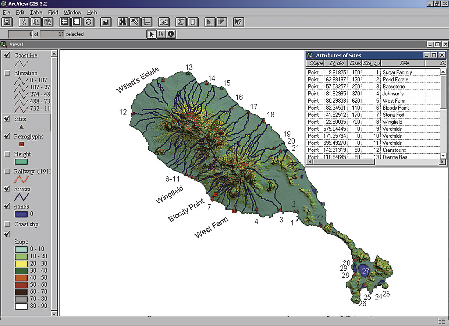
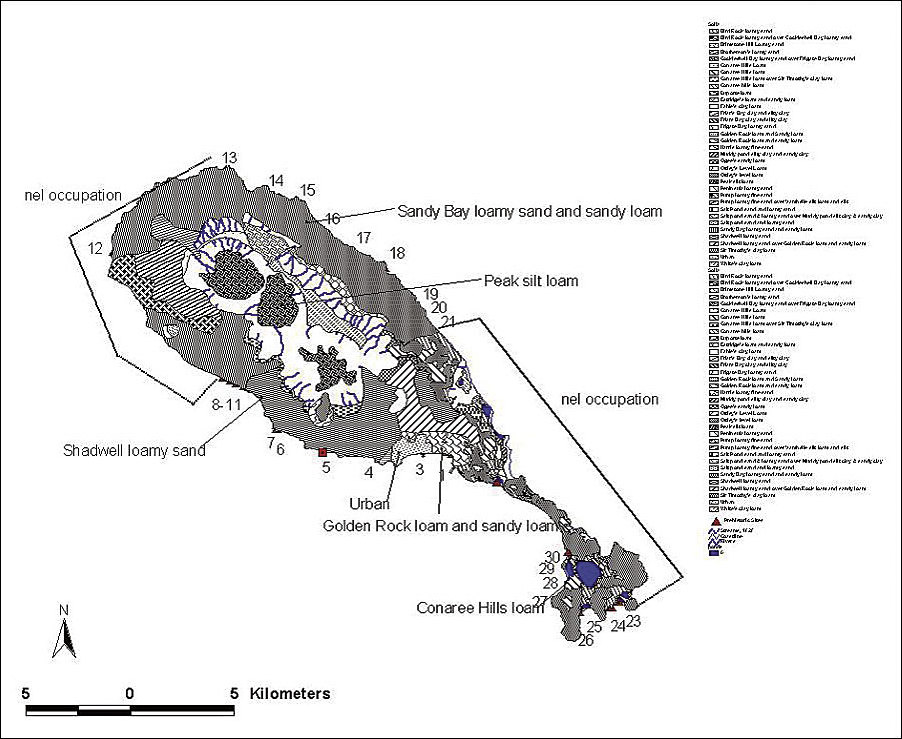
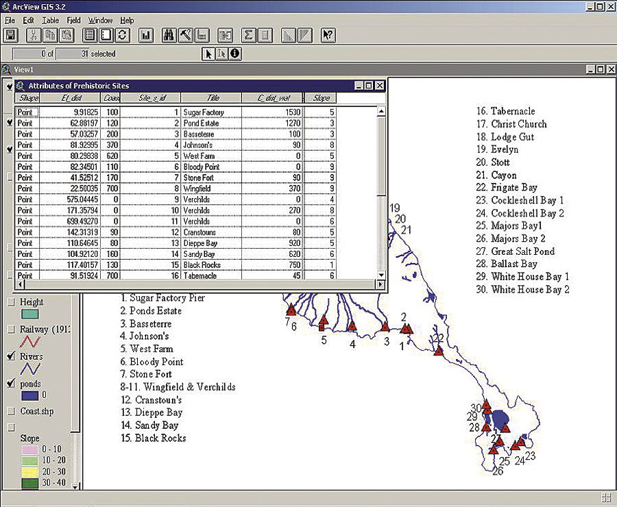
Application of MethodologyThe relevant information was combined, classified, digitized, or typed and input in a GIS database format for spatial analysis. ArcView was chosen due to the software's ability to manipulate multicomplex data efficiently and effectively. The land-use analysis was better viewed in polygon shapefiles. These were further supplemented with attributes. For instance, the digitized soil type, which was converted to a polygon shapefile, was examined in relation to the prehistoric sites. Island topography such as slope was produced using contour lines, with the rivers digitized from existing maps. Analyses needed to take into account the considerable changes of the island hydrology that have occurred during the previous two centuries; therefore, 19th century data resources were used. The archaeological sites were represented as points in the shape of a triangle and the locations of petroglyphs were shown as squares. These relationships then provided clear visualization for further analysis.
Spatial analyses of 30 specific sites (classification based on field surveys) done with ArcView revealed that the prehistoric settlers selected locations that were proximal to freshwater resources (i.e., all the sites were constructed at a distance of less than 100 meters from rivers). These sites were also consistent with land slope gradients ranging from two to five degrees. ConclusionThis study integrates complex data for an archaeological investigation that covers the whole island of St. Kitts in terms of settlement pattern. The study to date has revealed that the rugged topography of the island restricted the indigenous people from exploring further inland. This preserved a high-level rainforest and ensured a continual supply of freshwater from the rivers that originated at high altitudes. The influences of the indigenous activities on the local environment are centralized on regions that came under direct contact by settlers' activities. GIS provided new interpretations to past events. Results have stimulated further investigation for a better understanding of current environmental issues. Results also show potential for advanced analysis in the future, such as reexamining the changes in the island's landscape over the years, using the proven technology of GIS. At the completion of this project, the developed methodology will be applicable for other islands similar to St. Kitts. In a follow-up investigation, the relationship between selecting places for settlement, which is indicated by sites, and coastal characteristics is being fully examined. For more information, contact Madiha A. A. Farag, c/o Department of History, Faculty of Humanities & Education, the University of the West Indies (e-mail: madfarag@yahoo.com). |