Spring 2006
Spring 2006 |
|||||||
|
|
|||||||
User Conference 2006 Set for August in San Diego |
|
|
This year's 26th Annual Esri International User Conference offers an opportunity to find out what's new and what's next in GIS technology. Participants in the most important GIS meeting of the year will gather to share ideas, challenges, and successes August 7–11, 2006, at the San Diego Convention Center in San Diego, California. The conference brings more than 13,000 attendees from more San Diego's modern convention center and varied tourist attractions make it a great place for the conference. So great, in fact, that 2006 will be the 10th consecutive year Esri has held the annual meeting there. The center's expansive plenary space provides the venue for thousands of participants to gather and hear Esri president and founder Jack Dangermond's annual review of industry trends and vision for the future, followed by an inspiring keynote speaker presentation. Among this year's special events is a celebration of the United States National Park Service (NPS) and its use of GIS technology to protect some of our most precious resources. (See "Invitation to International National Parks Track.") Park staff, as well as representatives from international parks, will present their experiences in meeting challenges they face for managing protected areas. A separate display area will show how the NPS uses GIS to meet those challenges every day to help protect fragile lands and guide development, while the Map Gallery exposition will include an area devoted to showcasing National Park maps. This special focus coincides with the NPS' 90th anniversary operating as a separate bureau of the Department of the Interior. National and International GIS Users at All LevelsThe Esri International User Conference provides both inspiration and down-to-earth information for aspiring and experienced GIS users alike. It unites users and organizations from around the world during a week of workshops, technology briefings, presentation forums, and professional interaction. The knowledge-sharing experience can introduce or reacquaint attendees with cutting-edge technologies and galvanize new and lasting organization contacts. Planners, educators, technicians, developers, and managers come together to exchange ideas about their industries and regions. Preconference Seminars and WorkshopThirty preconference seminars offered on Saturday and Sunday, August 5–6, 2006, will tackle issues ranging from GIS development and management, industry solutions, and Internet applications to data collection and technical skills acquisition. Subject experts will lead more than 2,000 attendees through half-day and full-day seminars on specific technical topics and areas of interest. Registration is separate from User Conference registration, and the deadline is June 23, 2006. Sign up for one or more seminars by visiting www.esri.com/uc. The Esri Petroleum User Group and Pipeline Interest Group will present the third annual workshop on the ArcGIS Pipeline Data Model on Saturday, August 5. The full-day event includes presentations on model usage, integration with other models, standards, spatial analysis, and custom software development. The free workshop is open to any registered conference attendee who signs up. For more information on GIS for pipeline, visit www.esri.com/pipeline. User Paper Presentations and Technical WorkshopsUsers from all corners of the globe will present more than 1,000 papers covering topics from project design and modeling to implementation and lessons learned. With more than 30 industries represented, GIS users will discuss their real-world experiences during these presentation sessions. Esri staff will head more than 300 technical workshops, offering tips and tricks for new software versions and the wide range of Esri products. Extra workshop sessions will be provided Friday morning before the closing session to give attendees a chance to catch a workshop missed during the week. Esri Showcase and Exhibit PavilionEsri staff will demonstrate the latest software, including ArcGIS 9.2, at the Esri Showcase. Knowledgeable personnel will be on hand to answer questions about technical support, application development, and educational services. Users can visit the Doctor's Office in the Esri Showcase to consult with the experts and get answers to their most pressing technical problems. Esri Business Partners, including hardware vendors, application developers, software value-added resellers, service providers, data providers, and other GIS-related companies, will display technology solutions at the Exhibit Pavilion. This year's showcase exhibits include defense; health and human services; and public safety, law enforcement, and homeland security sections. Map Gallery and ReceptionA Monday evening reception will kick off an international array of Esri user map products and posters on display in the Map Gallery during conference week. Don't miss the special collection of National Park maps in the Map Gallery, just one of several NPS contributions to this year's conference. The deadline for poster submission is June 16, 2006. Also on the calendar is the Academic GIS Program Fair on Monday, August 7, when representatives from college and university academic GIS programs will be on hand to discuss their educational offerings and Esri recruiters will be available to discuss internship and employment opportunities. More than 100 special interest groups will hold meetings scheduled for Tuesday, Wednesday, and Thursday. A three-day User Software Application Fair will kick off on Tuesday, and the deadline to request to participate in the fair is June 16, 2006. Concurrent EventsTwo additional meetings, the Sixth Annual Esri Education User Conference and the Fourth Annual Survey and GIS Summit, will take place concurrently August 5�8 at the San Diego Convention Center and nearby Marriott Hotel and Marina. (See "Esri Worldwide Business Partner Conference Highlights" and "Esri Developer Summit—A Great Success!") Social and Sports ActivitiesEveryone takes a moment to relax and mingle during an entertaining evening at the Thursday Night Celebration. Conference registration includes entry to the event, but be sure to purchase additional tickets for accompanying family and friends at the Esri UC activities desk during the conference. Upon registering, attendees may also sign up for sports activities, beginning with a San Diego Padres baseball game on Saturday, August 5. Participant sports include a preconference golf tournament on Sunday, August 6; the 5K Fun Run/Walk on Wednesday morning, August 9; and a tennis tournament on Tuesday and Wednesday, August 8–9. The GIS Kids Camp offers fun, educational sessions for registered attendees' children. Sessions spread over three days, August 8–10, and are available for students in kindergarten through 12th grade. The deadline for sports activities and GIS Kids Camp registration is June 23, 2006. RegistrationThis conference is for all levels of Esri GIS users from around the world. The registration deadline is June 23, 2006, and guidelines for attending are available by going to www.esri.com/uc. For further information, contact the Esri User Conference registration staff (tel.: 909-793-2853, ext. 1-1363; fax: 909-307-3128; e-mail: ucregis@esri.com). |
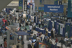 than 120 countries together under one roof to experience the ever-broadening range of GIS technology and applications. New and experienced GIS users can get connected and expand their knowledge, choosing from an impressive number of seminars, workshops, presentations, and user meetings.