Spring 2006
Spring 2006 |
|||||||
|
|
|||||||
Vietnam Veterans of America Foundation
VVAF and Esri Support Humanitarian Efforts with GIS |
|||||
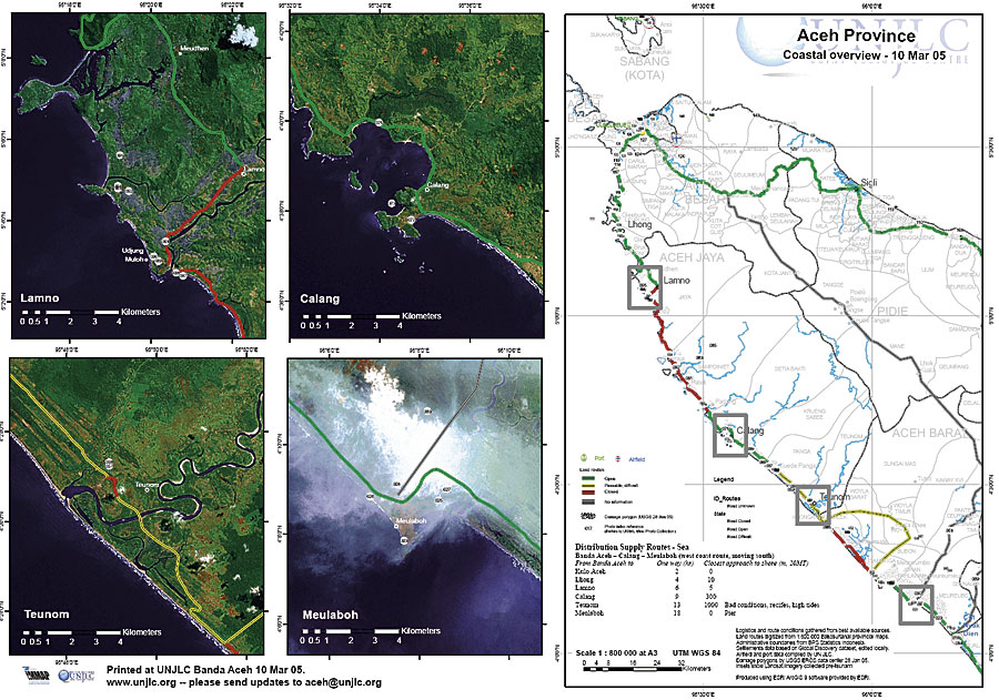
The Vietnam Veterans of America Foundation (VVAF) is an international humanitarian organization that addresses the causes, conduct, and consequences of war through programs of advocacy and service for victims of conflict. It is the cofounder of the 1997 Nobel Peace Prize-winning International Campaign to Ban Landmines. VVAF also implements rehabilitation programs that provide prosthetics for people with disabilities caused by war or debilitating diseases in Angola, Cambodia, Ethiopia, and Vietnam; it supports similar programs in Central America and sub-Saharan Africa. The VVAF Sports for Life initiative uses sports as a rehabilitation method for land mine survivors and victims of conflict in war-torn countries. Currently, VVAF is working with the Vietnam Ministry of Defense to survey and assess the impact of land mines and unexploded ordnance (UXO) that are remnants of the Vietnam War. VVAF's Information Management and Mine Action Programs (iMMAP) coordinates, supports, and implements this type of survey as well as other humanitarian information management activities. Results of this work provide a basis for setting priorities in humanitarian relief and development, economic recovery, land mine clearance, and victim assistance. (See "Iraq's Explosive Remnants of War Cleanup Is Supported by GIS" in the Winter 2004�2005 ArcNews.) In Information and Communication Technology for Peace: The Role of ICT in Preventing, Responding to and Recovering from Conflict, published by the United Nations in 2005, the authors say, "The NGO [nongovernmental organization] with most experience in this [GIS] sector, however, is the Vietnam Veterans of America Foundation, whose iMMAP project . . . has been instrumental in supporting both Mine Action initiatives and the HICs [Humanitarian Information Centers] operated by OCHA [the United Nations Office for the Coordination of Humanitarian Affairs]." iMMAP is a leading advocate for establishing standards on the practical use of GIS in support of making decisions; defining the common operating picture (COP); and promoting interorganizational coordination, planning, and collaboration. For more than seven years, VVAF and Esri have worked together to provide GIS technology and applications that support humanitarian efforts in nations recovering from violent conflict. "The Esri team has provided critical in-kind and technical support to our efforts aimed at helping those most in need," says Joe Donahue, vice president for Programs, VVAF. "Esri has always been there for us, especially at times when a delay of days or hours might cost lives." The following is an update on VVAF GIS-based activities over the past 18 months. Indian Ocean Tsunami Relief ProjectAfter the December 2004 South Asia tsunami disaster, iMMAP received funding to provide technical support to the United Nations Joint Logistics Centre (UNJLC), a project of the World Food Programme, for humanitarian tsunami relief efforts. Funds came from the UNJLC and the International Emergencies and Refugee Health Branch, a branch of the U.S. Centers for Disease Control and Prevention (CDC) National Center for Environmental Health. This support allowed VVAF to quickly send technical experts to Indonesia, Thailand, and Sri Lanka and to support humanitarian assessments. At the height of this deployment, VVAF had 11 technical experts in the field.
Using Esri-provided ArcGIS 9 (ArcView, ArcInfo, ArcEditor) licenses and extensions, VVAF produced the first up-to-date, ground-verified road condition maps for the affected west coast of Aceh province in Sumatra, Indonesia. These were updated weekly as Indonesian military engineers completed construction of new roads and bridges. VVAF also provided critical equipment and GIS support to the U.S. Army Corps of Engineers and Japanese government engineering teams for their road/bridge construction project assessments in Sumatra. "Because we store our geodatabases in Microsoft Access, it was very convenient and efficient for the emergency responders since they could move between the database and GIS environments," says VVAF's lead Indonesia responder Mark Yarmoshuk. Tables of information—for example, helicopter landing zones being used for emergency relief drops—were quickly mapped from the same data source used to record what equipment had been delivered to the sites. ArcView made it easier to process and tile the raster data (scanned maps, Landsat, and high-resolution images), while the Maplex for ArcGIS extension supported advanced labeling for printing map sheets. ArcGIS Military Analyst was used to access data provided in military formats, and ArcGIS Data Interoperability sped up sharing of different data formats. Additionally, ArcView made it easy to work with metadata stored inside the geodatabase. Demining in LebanonFive of Lebanon's six provinces have at least some land mine contamination, with the provinces of Nabatiyah and South Lebanon being most heavily affected. The Information Management System for Mine Action (IMSMA) is the global standard management application for compiling available land mine/UXO hazard, social, and economic information related to ground verification of suspected contamination. (See "IMSMA IMSMA GIS and Analysis Tools Support Demining Efforts.") Used by the Lebanon National Demining Office (NDO), IMSMA holds Land Mine Impact Survey (LIS) data gathered by VVAF and its partners and incorporates GIS functionality using an Avenue language-based extension link. Under a project funded by the U.S. Department of State's Office of Weapons Removal and Abatement, VVAF helped NDO assess its operational needs for additional IMSMA functionality. The resulting application, Operations Explorer (OpEx), was developed based on broad operational needs identified by the NDO in Lebanon and the Humanitarian Mine Action community. OpEx is stand-alone software that complements IMSMA. It integrates GIS and data management functions into a single user interface focused on streamlining NDO's operational use of LIS data. Created with MapObjects, OpEx queries and retrieves LIS and other IMSMA data as well as data from external sources. Response to the Pakistan EarthquakeWhen a 7.6 magnitude earthquake hit northeastern Pakistan in October 2005, it killed more than 70,000 people and left tens of thousands homeless. UNJLC and VVAF responded quickly, but the area's remoteness and rugged mountains posed huge transportation and logistical challenges to relief groups. Working at the UNJLC branch in Islamabad, VVAF personnel compiled cartographic information and assisted in the adaptation and application of existing transportation and logistics models to the specific conditions in Pakistan. VVAF acquired high-quality Pakistan survey maps of the affected region and conducted field reconnaissance in the Muzaffarabad area. Using ArcGIS 9 (ArcView, ArcEditor), VVAF was able to compile from disparate sources the best available datasets of roads, settlements, population, climate, and boundaries for basemap production. The team created helicopter landing zone data and a map series, generated a multilingual place-name converter, and compiled a climate dataset for a special map series used during winter operations. Health Information System for Refugee Camps in TanzaniaTanzania's refugee camps house approximately 400,000 refugees from neighboring East African countries. Health information is needed at all administrative levels, from camp managers to United Nations agencies to CDC researchers seeking a global picture of the issues affecting refugee health. In response, VVAF developed the Health Information System (HIS), an information management solution for collecting health data and statistics in 11 refugee camps in western Tanzania. Tanzania's poor infrastructure, intermittent electricity, scarce and expensive Internet access, and limited technical staff constitute a tough environment for collecting, storing, and using health data. In addition, a wide variety of organizations involved in camp management employ personnel with varied technical abilities using a range of equipment. Therefore, any information technology solution must be simple to use and run on low-end computers. The solution consists of a Microsoft Access database using the MapObjects LT ActiveX control to enable the creation of GIS capabilities directly within the HIS application. Access was used to facilitate rapid prototyping of the system. Users can enter data directly into the database or import Microsoft Excel spreadsheets that the system automatically geocodes according to camp location. Analysis and graphing functions are also provided. MapObjects components allow users to immediately visualize the HIS analysis results and produce maps from the data. The software choices allowed resources to focus on refining the data model and information flow, and the software platform is easily deployed without making major upgrades in computing machinery and telecommunications. The next step, to implement an enterprise solution, will use ArcSDE to manage the geodatabase and ArcIMS maps on the Internet. "This will permit data collection at shorter intervals and incorporate more detailed camp maps," says Andrew Ross, HIS technical advisor to VVAF. Further development will be driven by user needs. Democratic Republic of Congo Explosives Contamination AssessmentIn the Democratic Republic of Congo (DRC) explosive remnants of war are a fact of life. Since the early 1960s, DRC has seen varying levels of conflict that resulted in large areas contaminated with UXO. VVAF partnered with the Mines Advisory Group to develop a survey methodology and tools to effectively match Explosive Remnants of War Contamination Assessment information with technical clearance and disposal requirements. This project provided the national and international communities with relevant, high-quality, standardized data regarding the socioeconomic impact of land mines and UXO in DRC. Funded by the U.S. Department of State's Office of Weapons Removal and Abatement, the completed phase 1 survey helped the United Nations Mine Action Coordination Centre in Kinshasa, the DRC capital, allocate scarce mine action resources based on social and economic needs. With field-tested methodology and protocols in place, the development of a Hazardous and Abandoned Ordnance Survey Tool (HAOST) database application and user interface was completed during phase 1. The database structure is based on Microsoft Access and was developed to be compatible with IMSMA. The user-friendly interface allows for easy navigation during data entry and allows users to query the database, produce reports, and create maps with locations of affected communities. HAOST uses MapObjects to provide maps so each georeferenced community's GPS coordinates and attribute data can be verified as close to the point of collection as possible. Phase 2 of the project began in March 2006. Funding for phase 2 of this survey is provided by the United Nations Mine Action Service. New Tool Helps Monitor Worker Safety RisksInternational relief, development, and nongovernmental organizations, not to mention civilians, face severe operational and travel restrictions in places such as Afghanistan, Iraq, and Sudan. These work environments are extremely dangerous and pre-sent high personal security risks. As a result, VVAF has begun developing a secure, Internet-enabled tool, the Operational Activity Security Information System (OASIS). OASIS will provide humanitarian and development organizations with a toolbox that allows them to gain a true COP of the security risks confronting their projects and personnel at the operational level. The core of OASIS consists of a GIS-based security assessment system. During development, VVAF is using programming tools available through the Esri Developer Network (EDN) to assist in the sharing, display, and analysis of georeferenced security data. The finished OASIS system will provide users with an easy-to-use set of tools that allows organizations operating in volatile environments to assess and react to security threats that may affect their projects and workers. For more information on VVAF projects, visit www.vvaf.org. |