Spring 2010
Spring 2010 |
|||||||
|
|
|||||||
GIS Improves Water Management in Saudi Arabia's Eastern Region |
|||||
|
By Hussain Ammar and Haytham Abd El-Moniem Highlights
The General Directorate of Water in the Eastern Region (GDWER), Kingdom of Saudi Arabia (KSA), is actively engaged in providing all types of water services in the eastern region of KSA. The organization's principal responsibilities are to design, develop, and implement all water and wastewater network projects, as well as water treatment projects. GDWER also aims to establish a solid structure for the successful operation of water and wastewater utilities.
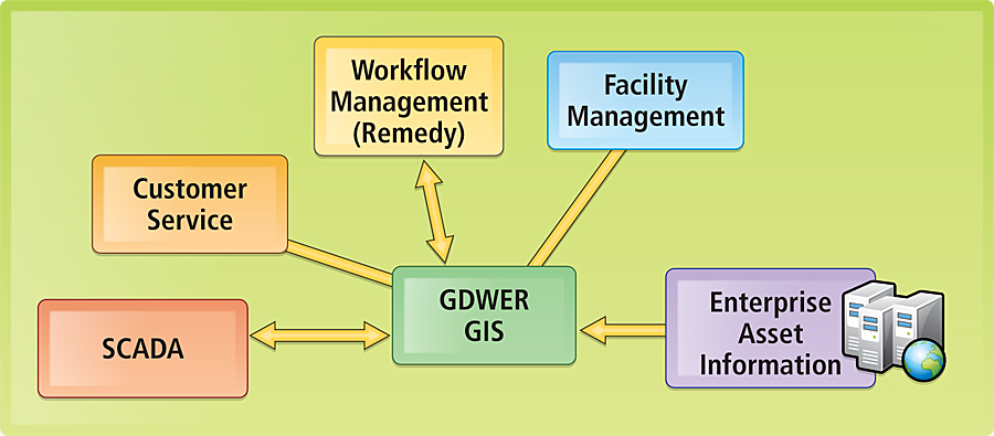
GDWER is located in Dammam, the capital and largest city of the eastern region, situated on the coastal strip of the Arabian Gulf and bordered by the gulf on the north, east, and south. Other cities that surround Dammam are Khobar, a thriving modern economic hub; Al-Dhahran, headquarters for Saudi Aramco, the largest oil company in the world; and Qatif, a well-populated fishing and agricultural town. Together, these cities have a population of two million people. There are 600,000 people living in the city of Dammam. Every year, GDWER receives thousands of calls in its service center from people reporting issues such as burst pipes and interrupted water supply. The directorate has a duty to respond quickly to these incidents. However, it wasn't always easy to establish precisely where the problem had occurred. Previously, GDWER had islands of technology and silos of information around the directorate. Data was not shared and was often duplicated. After a thorough evaluation process, GDWER selected Moammar Information Systems (MIS), Esri's distributor in Saudi Arabia, in association with Esri Northeast Africa (Esri NeA), to implement an enterprise GIS solution utilizing Esri's ArcGIS Server technology. A unified, spatially enabled water and wastewater data model was built as the basic foundation for the project. The data model represents all water and wastewater elements, such as wells, pipes, treatment plants, fittings, and house connections. GDWER is now using the GIS solution to manage its underground assets. Key to the success of the GDWER strategy was the implementation of the enterprise asset management (EAM) system. The implementation of an enterprise GIS system enabled GDWER to successfully integrate the EAM system and its location-based asset information, such as pipes, meters, and water treatment plants, with the associated attribute data stored in GIS.
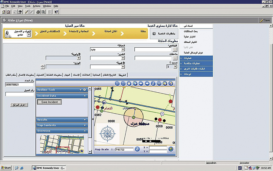
The GIS was successfully integrated with the SCADA system for the well network. The integration allows the GDWER SCADA system to be a part of the central IT network and information infrastructure for quicker response to any malfunctions or anomalies occurring within the well network systems. GDWER implemented a call center using Remedy software. When the call center receives a customer call, the system initiates operational response, then uses a predefined workflow to manage event tracking and logging. The workflows developed within the Remedy system allow GDWER to define and manage its standard operating procedure to support the call center system. The workflows will analyze the system's automated response to an event and escalate the response to a higher level if required. Through the Remedy system, the user can automatically record an exact location for each event in the network and analyze it to determine the impact on the surrounding area. Using the map location as a reference, the system can then identify assets GDWER has at any particular location and dispatch work crews to respond to the event. About the AuthorsHussain Ammar is project manager for GDWER. Haytham Abd El-Moniem is project manager for Esri NeA. More InformationFor more information, contact Hussain Ammar, project manager, GDWER (e-mail: halammar@mowe.gov.sa); Syed Athar Ali, customer service manager, MIS (e-mail: gis_maint@mis.com.sa); or Haytham Abd El-Moniem, project manager, Esri NeA (e-mail: haytham.moniem@esrinea.com). |