iPC Develops an Array of Map Content for Japan
Sophisticated Map Editing and Workflow System Developed
Highlights
- iPC uses GIS to quickly and efficiently create up-to-date and highly accurate map data.
- A twin-track approach consists of database building and editing system development.
- Multilanguage maps of Japan are provided to companies that plan to utilize the maps.
INCREMENT P CORP. (iPC), a digital map supplier and software development company owned by Pioneer Corporation, has been creating and compiling map data and developing software since 1994. iPC is responsible for Japan's first map discs for in-car navigation systems, marketing map software for PCs, providing packaging solutions for personal navigation devices, and supplying Japan's first off-board navigation application for the iPhone. Today, the company offers a wide array of map data and map services for use by markets around the world from its head office in Kawasaki, Kanagawa Prefecture, Japan, as well as locations in Shanghai, China, and the United States.
iPC compiles and retains in-house map contents, such as road network, map background, and address data. Also, it developed a spatial database system based on ArcGIS to achieve an environment for quickly and efficiently creating up-to-date and highly accurate map data. The company can make available attractive data to the highly competitive in-car navigation industry and Internet map service market.

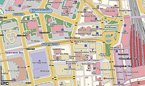
A map of the Shinjuku area, Tokyo, with English labels of shopping spots, restaurants, banks, schools, and so on.
In the past, the conventional systems had maps of Japan separated into files by units called meshes, delimited as tiles, and all of Japan was managed as data files consisting of tens of thousands of meshes. Making individual map meshes consistent with their adjacent meshes required much labor and time for alignment work. Only one person was allowed to edit each specific file in the database due to exclusive access control, which made operator work planning and management cumbersome.
Thus, iPC compared and studied a variety of GIS/CAD tools to overcome these problems and make the map editing workflow more efficient. As a result, iPC adopted ArcGIS. A twin-track approach was then taken for the new map system building project consisting of database building and editing system development. The following three goals were achieved with the new ArcGIS integrated spatial database:
- Making maps for all of Japan seamless and integrated
- High-level data modeling
- High-performance, multiple, simultaneous editing
With map editing, up to 200 operators may be editing and saving data at the same time. That could involve hundreds of thousands of transactions a day, and thus high performance was needed to secure work efficiency. Yet iPC released map data created by its new system in autumn of 2003.
The system that was initially developed only for basic map contents has been expanded into a map editing system to handle quickly evolving navigation products and map services, as well as diversifying contents and expanding business. Today, this GIS map editing system carries out work such as information management, including changes to roads and features across Japan and map information from users. This is in addition to work for conventional point of interest (POI) content and new content, such as road height and gradient. iPC has been constantly providing the market with leading-edge and multifaceted map data by making the most of this system. One example of such data is multilanguage Japan map data.
Japan has been actively enticing tourism from abroad, with the public and private sectors working together on projects such as the Visit Japan Campaign. In light of that, using ArcGIS, iPC developed a multilanguage Japan map database in 2009. This database comprises Japanese map data translated into English, Chinese (traditional and simplified), and Korean and covers 84.7 percent of the native or official languages of visitors to Japan. In this way, iPC is contributing to the creation of a variety of mapping solutions required for internationalization, such as navigation systems and websites for foreign visitors and foreign residents in Japan.
The multilanguage map database is made up of map notation, address, and POI data. It encompasses all of Japan and is compiled with multilingual notation in detailed maps (at 1:3,125 scale), assuming pedestrian use especially in major urban areas. That information is translated from Japanese and includes public facilities, shops, and the like, required by foreign visitors, as well as sightseeing location names and embassies.
Multilanguage Japan maps created with ArcGIS are provided to companies that plan to utilize the maps themselves either in shapefile format or by Multi-language MapFan onPage on web ASP services. Maps can be included with commercially available or in-car navigation products, mobile phones/smartphones, fleet management systems, and more, for use in a variety of environments and applications. Data is compatible with the World Geodetic System in anticipation of global usage. Some major implementations of the products are multilanguage maps for services such as Japan National Tourism Organization's (JNTO) JNTO Travel Planner (www.jnto.go.jp) on its website and Kinki Nippon Tourist's Japan Traveler Online (Japantraveleronline.com) hotel reservation website for foreign visitors to Japan.
For more information, visit www.incrementp.co.jp/ml/en or, for details on the multilanguage database, see www.incrementp.co.jp/english/multi_language.