Swiss National Mapping Agency Breaks New Ground in Geodata Products
Highlights
- Using GIS and photogrammetry in an integrated way, updating spatial information takes less time.
- The workflow implemented using ArcGIS streamlines production processes.
- Data is collected and stored in 3D, allowing z-values to be leveraged.
Traditionally, the key task of national mapping agencies like swisstopo (the Swiss Federal Office of Topography) has been the production of national map series. In recent years, the need for digital topographic base data has continued to increase because it is used to produce printed paper maps, as well as a variety of products, including digital multimedia products, digital elevation models, and 3D city models. For swisstopo, the increasing demand for better, more up-to-date, and more diverse digital data has meant that the generation and rapid updating of such products has taken on a high level of importance.
TOPGIS successfully marries GIS and digital photogrammetry, providing the infrastructure for the production of the TLM and DTM (images and maps courtesy of swisstopo, � 2009 swisstopo).
To create this new type of topographic data products, swisstopo established a production infrastructure called TOPGIS. This system is used to create, manage, and update the new Topographic Landscape Model (TLM) of Switzerland, as well as update a corresponding digital terrain model (DTM).
The TLM serves as the base landscape model for Switzerland's spatial data infrastructure and is a central dataset from which many products can be derived. Every feature of the TLM is stored in a geodatabase with better than one-meter accuracy in all three dimensions. Using this process has a number of advantages for swisstopo: processes are streamlined, the time to market for products is reduced, data is more accurate, and a 3D model is created.
TOPGIS Streamlines Data Production
TOPGIS is used to capture, update, and administer the TLM and DTM. The system was created by ESRI Schweiz AG, a distributor of Esri's products in Switzerland, and is based entirely on ArcGIS, including desktop, server, and mobile GIS components. Stereo photogrammetry is fully integrated through Stereo Analyst for ArcGIS from ERDAS, Inc., which gives swisstopo stereo collection capabilities inside the ArcGIS environment.
TOPGIS was designed to solve the challenges swisstopo faces in data production. Workflows need to be addressed because up to 50 users may be working on several delivery versions of TLM in parallel. Operator productivity and system performance are crucial. Compared to the previous VECTOR25 landscape model used at swisstopo, the operators need to capture significantly more detailed data in a shorter amount of time. The production of a primary 3D model must also be addressed. This means that each vertex of each object must have accurate z-values.
As the national base landscape model, the TLM is seamless and covers all of Switzerland. It consists of 10 thematic categories ranging from land cover to man-made objects and, once complete, will contain approximately 20 million objects. These objects and all related information are stored in a geodatabase. Every vertex of the TLM objects has x-, y-, and z-coordinates, so objects in the TLM can and should stay consistent with the DTM. Originally captured by a lidar sensor, the DTM includes mass points and breaklines and is photogrammetrically updated simultaneously with the updating of the TLM.
3D Data Capture
The third dimension of the TLM is captured either photogrammetrically based on high-resolution ADS40/ADS80 stereo imagery or, alternatively, by monoplotting using orthophotos and the DTM.
Twenty-inch planar stereo screens are used for stereo viewing. The polarized left lens of the glasses blocks light from the top monitor, while light from the lower monitor is blocked by the right lens. This technology allows flicker-free operation under any office's ambient light.
Three-dimensional stereo mode is used in many situations, such as when capturing objects that form or shape the terrain, for example, waterways, roads, and railways; to edit the DTM; and to capture the heights of objects, such as roofs, electric poles, and bridges.
Although the TLM is 3D, not all objects are edited in stereo mode. This is because they "sit" on the terrain, so they assume their z-values from the underlying DTM. Some examples include hiking trails, land cover, and boundaries.
In TOPGIS, mono and stereo capture are seamlessly integrated. To change modes, the operator simply moves the cursor from the 3D screen to the 2D screen or vice versa. All objects are always visible on both screens.
Parallel-Release Cycles of Products Are Possible
Using the geodatabase allows swisstopo to create and maintain multiple parallel-release cycles of the TLM. Within each release cycle, the operators' work is organized into work units that define a perimeter within which a defined set of layers can be edited. Automated batch jobs reconcile the operators' daily work with the release cycle during the night, which helps prevent uncontrolled growth of the database state lineage tree.

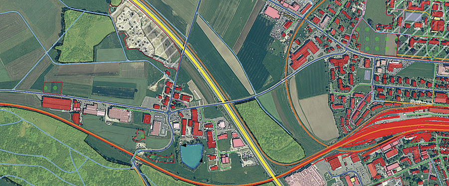
TLM data overlaid on an orthophoto (� 2009 swisstopo).
During the reconciliation step, conflicts may be detected between the edits of different operators. For example, a road object extending over more than one work unit may have been edited by several users. The system will first try to automatically resolve conflicts. If automatic resolution is not possible, TOPGIS assigns the conflicts to a work list that is subsequently checked and manually resolved by an administrator.
Periodically during data collection, and particularly when a release cycle is completed, a multilevel, rule-based quality assurance system ensures that a predefined level of quality is met. This modular, high-performance QA system was built especially for TOPGIS and includes 3D tests.
One step in the TLM production chain is improving and completing the TLM data in the field using ruggedized handheld Tablet PCs and GPS receivers. The data is checked out from the central database in the office and subsequently edited in the field. Because Tablet PCs are used, the full functionality of ArcGIS is available to the field topographer. The GUI differs only slightly from the office mono clients. Support for GPS data capture and GPS postprocessing is supplied by the GPS Analyst for ArcGIS extension from Esri Partner Trimble Navigation Limited.
Increased Productivity
To minimize the number of mouse clicks, mouse movements, and menu calls, special tools and mechanisms were built.
All relevant edit tools are available on a configurable toolbar for direct access. This toolbar can also be displayed as a pop-up menu at the current cursor position. A number of specialized tools were developed, for example, for automatically adjusting complex geometries to each other.
As the user selects which object to capture next, TOPGIS automatically sets all the edit properties, e.g., snap settings, z-capture rules, and default attributes, based on the type of object behind the scenes. These settings are predefined by an administrator and loaded automatically depending on the actual context. The operator can override the defaults if needed.
A rule engine enforces a set of consistency rules at each edit operation, helping the user prevent errors while editing. The rule engine is designed in a way that the user is not distracted by any delay.
Because TOPGIS integrates desktop, server, and mobile GIS, as well as digital photogrammetry, no data conversion steps are necessary to traverse system boundaries, as it used to be with previous solutions. Conversion is only necessary when data from third parties is imported, such as road authorities or national mapping agencies of neighboring countries, or when products are exported for customers. An individually developed component called DataHub, based on Esri Partner Safe Software's FME, is used to do import and export jobs.
The hardware and software infrastructure supporting the productivity of TOPGIS is designed to ensure short response times even with the large data volumes used. To ensure availability, a DBMS failover mechanism is used. (Failover is the capability to switch over automatically to a redundant standby database.)
In operation since 2008, TOPGIS successfully marries GIS and digital photogrammetry, providing the infrastructure for the production of the TLM and DTM. This modern infrastructure has a strong emphasis on productivity and workflows, allowing swisstopo to efficiently produce an up-to-date, primary 3D dataset designed to serve as the basis for a variety of products—not just maps.
For more information, contact Martin Suter, ESRI Schweiz AG (e-mail: m.suter@esri.ch).