Damage Control
Geospatial Mapping of Infrastructure Elements Essential for Effective Disaster Recovery
By Darrell Rigsby, GIS Analyst, Geospatial Research and Applications Center, and Matt Donaldson, MBA Student, Auburn University
Highlights
- GIS and GPS map at-risk surface-level utilities, such as fire hydrants and gas valves.
- Faculty and students had been trained to use these technologies through the Department of Geology and Geography.
- Many of the project's major stakeholders, including the cities' GIS departments, already use ArcGIS.
Auburn University, Auburn, Alabama, researchers are completing a project in which they mapped surface-level critical utility infrastructure elements (such as fire hydrants, gas valves, and sewer manholes) along Alabama's gulf coast communities using GIS and GPS technologies. Such mapping is expected to help locate these elements more quickly after a natural disaster, thereby further reducing damage occurring during the cleanup process. The GIS technologies used, processes developed, and collaboration achieved among multiple partners can be replicated in other coastal communities in hurricane-prone areas to protect these coasts, as well.
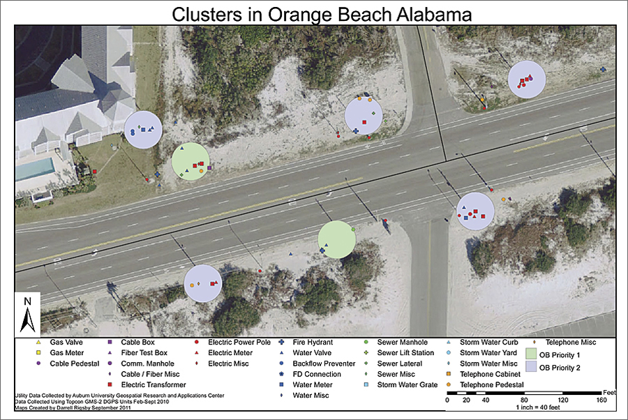
Example of maps created for stakeholders containing location of utility elements and priority cluster system.
Helping coastal communities recover after a disaster is critical. By 2025, it is projected that 75 percent of Americans will live in coastal counties (Henrichsen). Hurricanes and tropical storms are the major threats that affect the coastal areas. Over the past eight years, hurricanes and tropical storms have caused more than $200 billion in damages, mostly along the United States Gulf Coast.
During the recovery process, in many instances, it is found that debris and sand have been deposited over the roads and throughout the area, making it difficult for cleanup personnel to know where infrastructure is located.
Says Robert Craft, mayor of Gulf Shores, Alabama, "The City of Gulf Shores has endured six disaster declarations since 1995 due to tropical storms and hurricanes, and accidental damage to utilities buried by storm-displaced sand has been a major problem for our utilities that slows the recovery process."
Due to the size of equipment and the lack of knowledge on precise locations of the utility infrastructure, buried utilities are at risk of becoming destroyed further by cleanup personnel. If utilities such as natural gas meters and valves remain damaged, they pose safety risks for those working to clean up the disaster zones. This led to a research team directed by Auburn University (through its Esri campus-wide site license) to map the utility inventory, providing it to the cities and utilities and adding the information to a centralized system (such as Virtual Alabama) that may be readily accessed.
As the spatial mapping began, ArcGIS proved its mettle. First, the Auburn community has faculty and students from multiple departments who are familiar with Esri products and who have been trained to use these technologies through the Department of Geology and Geography. Second, the Topcon GPS equipment the team used easily exported real-time data directly to ArcGIS for Desktop as shapefiles without the need for any further processing. Third, Esri software is also used by many of the major stakeholders in the project, including the city GIS departments. Therefore, it was an obvious choice for easy transferability. The Auburn team is also currently working on setting up ArcGIS for Server to allow remote access to data in the event of a disaster.
The benefits of this project are both economic and social. Alabama has two coastal counties, Mobile and Baldwin, that make up almost one-third of the state's tourism tax revenues. Reducing the damage done to critical utility infrastructure during the cleanup process following a natural disaster would save the cities, public, and utilities money, time, and valuable resources.
Says Kit Alexander, director, Information Systems, City of Orange Beach, Alabama, "The GIS data provided by this project will allow the city to quickly locate and determine the extent of damage to the coastal infrastructure, which leads to speedier reentry of our residents and business community, ultimately decreasing the negative impact of the storms on our island community."

An undergraduate Auburn University student collecting location of utility in Fort Morgan, Alabama, using a Topcon GPS unit.
Auburn researchers obtained a grant from the Economic Development Administration to map the coastal communities of Alabama using GPS and GIS technologies. One goal of the project was to integrate the utility information into one easy-to-use format that is easily accessible in the event of a tropical storm along Alabama's gulf coast. Prior to this project, most utility infrastructure geospatial data for the Alabama communities was in many different formats, including paper maps, specialized CAD systems, and GIS systems.
"By mapping utility infrastructure points using GPS," says Stan Wright, mayor, City of Bayou La Batre, Alabama, "the time spent repairing and restoring services to our community will be dramatically reduced by knowing exactly where the utilities are located."
To combat these problems, Auburn recruited undergraduate students from geography, business, and engineering majors to collect GPS information of utility infrastructure elements. The undergraduate students were led by graduate students from geography and information systems departments. Over the course of a year, the students collected more than 12,000 data points along 50 miles of right-of-way utilizing mapping-grade differential GPS equipment.
In addition to student data collection, the team obtained utility data from respective utility companies and city departments to improve the accuracy of the product, as well as to incorporate necessary labeling information that is important to each respective utility. In total, over 100 students participated in the project in five Alabama coastal communities: Gulf Shores, Orange Beach, Fort Morgan, Dauphin Island, and Bayou La Batre. Due to the large quantity of utility elements mapped, the team developed a priority cluster system to minimize the quantity of points to flag in the event of a disaster while still protecting the most important facilities in the community. Each cluster contains three or more utilities within a 30-foot-diameter circle. This cluster system reduced the quantity of physical points from 10,000 for two communities to approximately 400 while still protecting thousands of the most important community utilities.
States Vaile Feemster, manager, Dauphin Island Water and Sewer Authority, "With the tools and knowledge provided by the staff of the geospatial program, the Authority will be better able to meet the needs of our citizens in the future. The ability to quickly identify critical infrastructure will free up man-hours, eliminate repairs and cost due to infrastructure damaged as a result of road-clearing crews, and allow us to continue our focus on providing water and sewer."
About the Authors
Darrell Rigsby is a recent graduate of Auburn University, with master's degrees in geography and community planning. He was the lead graduate student on this student-run project. He is currently working with Auburn University's Geospatial Research and Applications Center. Matt Donaldson is currently an MBA student at Auburn University College of Business. His undergraduate degree is in geography from Auburn.
Reference
Don Henrichsen, Coastal Rivers of the World, Island Press, 1998.
For more information, contact Dr. Chetan Sankar, director, Auburn University Geospatial Research and Applications Center (e-mail: sankar@auburn.edu, web: www.auburn.edu/grac).