HELCOM Powers Up Baltic Sea Map Service
Multiple Map Services Rolled Up into One Server Platform
Highlights
- GIS makes the HELCOM GIS map and data service flexible.
- Through ArcGIS for Server and ArcGIS API for Flex, Baltic Sea data is available from one centralized place.
- HELCOM GIS is visually interesting and functionally fast.
Northern Europe's Baltic Sea has a combination of geographic, climatic, and ecological characteristics that make it highly sensitive to environmental impact. Because it is shallow and almost enclosed, its brackish water remains within the sea for up to 30 years.
The environmental quality of the sea and its coastlines has deteriorated due to a long history of discharges from industries and municipalities, runoff from agriculture, and various airborne pollutants. These pollutants, combined with the basin's natural tendency to stagnate, endanger the Baltic Sea's living resources. Much work has been done to reduce pollution in the last few decades, so the deterioration has slowed.
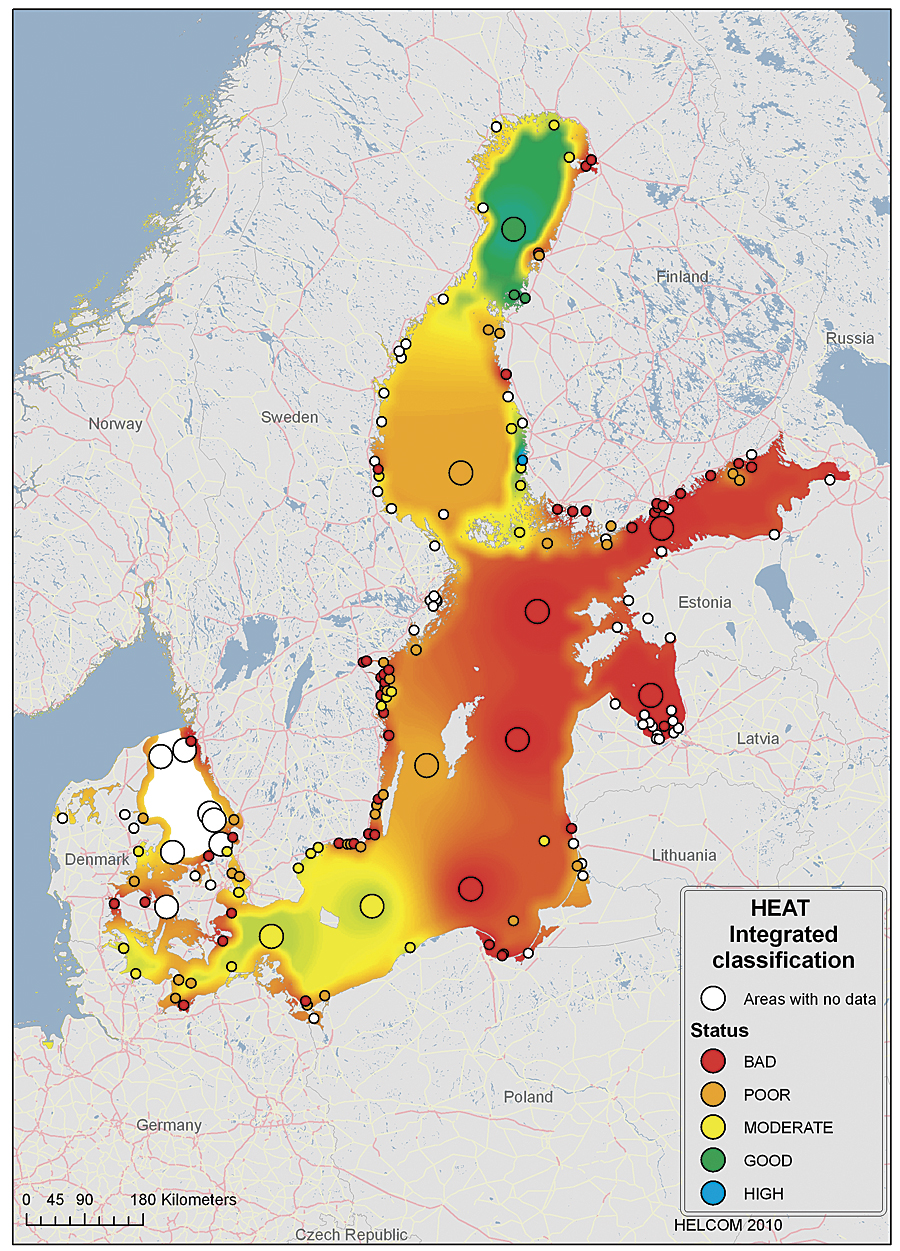
Heat-integrated classification shows the status of eutrophication in locations around the Baltic Sea.
The Baltic Marine Environment Protection Commission (commonly known as the Helsinki Commission, or HELCOM) is an intergovernmental organization of all nine Baltic Sea countries and the European Union; it works to protect the marine environment of the Baltic Sea from all sources of pollution. For more than 30 years, the commission has been assessing and reporting on the status of the sea. These reports, based on unique compilations of data and analysis, help experts evaluate the impact of human activity on the marine environment and formulate policies and priorities to protect the environment and ensure sustainable use of its natural resources.
HELCOM has used Esri's software for processing and analyzing data since 2004. The commission's GIS-enabled website provides users with access to the organization's various map and data services, including maritime accident response, nutrients, maritime spatial planning, coastal fish monitoring, metadata, the Baltic Sea Monitoring Programme, and project data. HELCOM recently migrated these to the ArcGIS for Server platform, which integrates all these services into a single map service.
"In the last few years, the commission's operations have increasingly utilized GIS," says Minna Pyhälä of the HELCOM Secretariat. "Now, with the new service, users can search for material themselves and do what they want with it. This reduces our workload dramatically. The map service is also an implementation of HELCOM's data and information strategy, which aims to make all HELCOM data openly available to the public."
As a result, Baltic Sea data is available from one centralized place. This makes it much easier for people to use maps and data to understand the Baltic's ecology, protected areas, pollution, maritime traffic, and fishing industry. Hosted on the commission's server, the GIS platform makes the map and data service more flexible. Users can access data via a friendly table of contents; select and combine data layers of interest; and use various GIS tools, such as adjusting layer transparency.
The new map service was built on ArcGIS for Server and ArcGIS API for Flex. Flex, an Adobe development platform based on an Adobe Flash Player client, is well integrated with ArcGIS for Server. Using it to build the map service made the development process relatively straightforward and the applications easy to deploy.
Project researcher Manuel Frias, who developed the HELCOM GIS, explains, "ArcGIS for Server has made our map services visually and functionally better because the service is much faster. It is more user-friendly, providing easy map navigation (zoom and pan), and has a look and feel similar to other popular web map services. Moreover, we can easily tailor applications to include special tools and services, such as exporting WMS or KML."
Users who want to use datasets in their own ArcGIS software can either connect to the HELCOM database via a Web Map Service (WMS) or download material in Esri shapefile format to their own projects. HELCOM's new map and data service provides Open Geospatial Consortium, Inc.-compliant WMS so that users can access available layers from within their own GIS mapping environments. The service is designed as a service-oriented architecture. All transactions between the Flash Player client and ArcGIS for Server occur via a REST-based service end point.
Although copyrighted data and maps cannot be downloaded, more than 200 map layers are contained in the service, of which 99 percent can be downloaded for personal use. In addition, attribute information for map objects can be downloaded in comma-separated variable format via the Search function, which means that data can be further used and edited in a spreadsheet.
Datasets hosted by other organizations can similarly be linked via WMS and displayed in HELCOM's map and data service.
Pyhälä concludes, "If a service has a live link to our database, you can be sure that you always have the latest version of our data available."
For more information, contact Minna Pyhälä, HELCOM Secretariat, Helsinki Commission (e-mail: minna.pyhala@helcom.fi).
Related Podcast
The Importance of a Marine Cadastre
Doug Vandegraft from the Bureau of Ocean Energy Management Regulation and Enforcement talks about the marine cadastre and mapping ocean resources. Listen to the podcast. [10:00 | 9 MB]