Summer 2002
Summer 2002 |
|||||||
|
|
|||||||
The City of Riverside, California, Takes Weed Abatement from Paper to Pixels |
|||||
Every year, government officials of the City of Riverside, California, inspect land parcels to ensure City codes for weed maintenance are enforced. This helps reduce fire and health hazards. Abatement only takes place after two mailed notices by the City and two on-site inspections by field-workers. If, after these many different warnings, code compliance has not been met, the City will provide weed abatement at the expense of the owner. Tracking whether land parcels were code compliant or not was a manual process. The Code Compliance Division at the City of Riverside used a loose-leaf Assessor Parcel Map Book to navigate through the City and identify parcels during inspections. Using the map book pages, the code compliance officer would estimate the assessor parcel number (APN) of a property. Once in the field, the officer would hand color the parcel maps to indicate to contractors which parcels required abatement work. Back at the office, the APN was used to look up owner information, which would then be input by hand to create labels for notices. This manual process allowed for potentially libelous errors. For example, since most noncompliant parcels are undeveloped, nondelineated land, errors in parcel identification arose, and some parcels were missed altogether; hand typing owner information for mailing labels sometimes resulted in data entry errors; and hand-colored parcel maps sometimes did not provide sufficient information for the contractors charged with cleaning up the property. City GIS Team Recognizes OpportunityRealizing that there were better ways to do this job, City officials approached its information services provider, Affiliated Computer Services, Inc. (ACS), of Dallas, Texas, for a solution.
"The opportunity to develop an ArcPad solution was obvious, and the code compliance manager was very receptive to the idea," continues Smith. "After a few formalities we began developing a solution to automate and standardize information retrieval in the field and allow for easy data download back in the office. Maximizing usability was a key requirement." The City GIS team understood that any application for use in the field had to be intuitive so non-GIS users could quickly master it. This would ensure buy-in by users. The application needed to help the code officers with their job. Together, the City and ACS implemented a Business solution using ArcPad 6 to improve existing methods and tools for weed abatement inspections by its code enforcement officers. ArcPad 6 and ArcPad Application Builder 6 provided the perfect platform for a powerful and cost-effective solution. Application development and quantifiable results were quickly achieved. Inspection time has been cut by 50 percent with a full return on investment after just one year. "The solution reduces the chance of errors either in identifying the lot or missing the lot altogether," says Cecelia Copeland, code compliance manager, City of Riverside. "It allows us to have more information ready to respond to citizen complaints or inquiries. And my favorite feature: it eliminates the need for highly paid, highly skilled employees to manually generate color maps for the contractor." User InvolvementThe code compliance officers were directly involved in the graphical user interface (GUI) design and were kept apprised of any changes from start to finish. The officers also selected the hardware to use in the field.
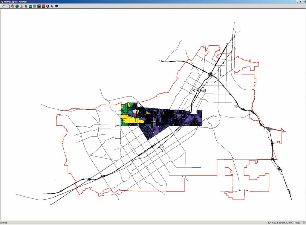
In addition to usability, the GIS team wanted a solution that would allow for improved routing to parcel areas. To solve this, the City purchased a GPS compact flash card (cfGPS) for each of the handheld units, which allows for automatic map navigation. The cfGPS cards were chosen for their size, low price, and lack of external cables. The employment of GPS dramatically simplified navigation by eliminating the need to flip through pages in map books and by clarifying parcel locations. GPS also eliminated the need to display a street layer. By default, the only layer that is needed is parcels. Users can toggle streets, city limits, inspection areas, zoning, land use, and orthophotos on or off. "One of the biggest benefits of the solution is the ability to easily navigate through the City," says Smith. "In the past, field-workers sometimes missed parcels in their jurisdiction, or some parcels were inspected twice. The ArcPad application eliminated this. Not only were workers able to better navigate throughout their jurisdictions, they actually discovered parcels that weren't known to have existed." How It WorksWhen the application starts, a screen appears identifying the parcels for which the officer is responsible. A simple GUI with buttons providing pan, zoom, refresh, search by address/APN, identify, and editing capabilities also appears. The GPS automatically starts up to show the officer exactly where he/she is on the digital map. During the first inspection, officers use one of two "editing" buttons to make changes to a shapefile containing parcels in their inspection areas. A click on a parcel with the "compliant" tool will mark a parcel as compliant and instantly shade the parcel green. A click with the "noncompliant" tool changes the parcel to brown. At the end of an inspection day, the officers download the edited shapefile to a server that is running an ArcMap application. Supervisors can track work progress by viewing inspection maps. Second inspection is exactly like first inspection, except now the "noncompliant" tool has been replaced by an "abate" tool. Inspections are limited to a simple connect-the-dot operation, navigating from one brown parcel to the next, using GPS. Each parcel that has been brought into compliance is clicked with the "compliant" tool; the database is instantly updated and the parcel is shaded green. Each parcel that is still not in compliance is clicked with the "abate" tool. At this point, a form pops up providing the officer with a combination of pulldown menus and radio buttons. This allows the officers to provide the necessary details about the work to be performed on the property by the contractors hired for the weed abatement. The process is kept simple and fast without the use of a keyboard. "A user must be able to describe work that needs to be done," says Smith. "Rather than creating a complex list, we customized the application with drop-down menus with keywords. A user can compose sentences like 'mow firebreak' or 'handwork hill.' This created a standard language that can easily be used to create a normalized database." At the close of the second inspection cycle, data is again downloaded to the server, where work orders are generated for the parcels that have been flagged for abatement. Work orders are printed and delivered to the contractor. Development of an ArcIMS application to provide additional services is under way. Front counter staff will use this application to respond to queries from the public regarding weed abatement. Managers will also be able to use this Web-based application to track progress. The positive feedback for the application may also lead to future field GIS application development. "The ArcPad solution is so easy to use even non-tech types feel comfortable with it," says Copeland. "And I can already see obvious potential for expansion beyond weed abatement." For more information, contact Steven W. Lindelof, ACS (tel.: 909-826-5420, e-mail: slindelo@ci.riverside.ca.us). |