Summer 2002
Summer 2002 |
|||||||
|
|
|||||||
Support for Government and Private Organizations
Esri Homeland Security Initiatives |
|||||
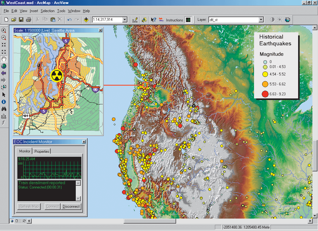
The events of September 11, 2001, together with the U.S. government's interest and leadership, have caused many organizations at all levels of government to see the benefits of creating solutions for better security of critical infrastructure. There is a growing awareness that a key component of homeland security strategy will be a GIS foundation (i.e., homeland = geography, and security = information). Esri has developed a series of homeland security initiatives, including a template for thinking through GIS-based security systems as well as supporting users with technology grants, training, and advanced educational materials, for local, state, and federal government agencies and private organizations. Esri has also created a Web site at www.esri.com/homelandsecurity to help people who are involved in homeland security. GIS is critical to homeland security because it enables integration of all types of information. Data from entities, such as water, sewer, utility, law enforcement, fire, health, and building and safety, can be easily integrated using GIS. This type of data sharing, analysis, and graphic representation speeds understanding of vulnerabilities, enhances event management, and improves the decision making process at all levels of response.
Esri's homeland security program is based on results from a small meeting held with technology, government, and private officials in health; fire; law enforcement; emergency response; and local, state, and federal government. The summit was held at Esri's headquarters in Redlands, California, to determine homeland security needs and develop processes for planning, preparedness, and response to homeland security threats. "The homeland security application is creating a lot of new interest in GIS and its capabilities for integrating critical data sets," says Jack Dangermond, president, Esri. "Our government user agencies at all levels are being asked to think about how they can use GIS technology and information to create systems that link multiple tiers of government. Homeland security is of paramount importance to our nation, and Esri is committed to supporting this in any way possible." "GIS provides a framework for thinking both locally and nationally about homeland security, whether it's for small rural communities, large urban areas, states, or even the nation," says Russ Johnson, Esri's public safety industry manager. "These new initiatives are key to dispersing the knowledge, skills, and tools vital to homeland security. They are also an important vehicle for bringing people together and utilizing the synergy that results." Esri initiatives include the following: A Technology Grant ProgramEsri is contributing 100 copies of GIS software to U.S. cities with populations under 100,000 people. Esri is also using an application process to award 10 enterprise GIS software grants to large government agencies. The grants will consist of software, training, and support. Esri plans that these grants will be pilot programs that allow Esri and others to observe and understand how to prototype the new applications. The grant program will provide a means for agencies of all sizes to utilize the power of GIS to conduct risk assessment, mitigation needs, preparedness analysis, and response assessment and to share data. Homeland Security Seminars
White Papers, Educational Materials, and More InformationPlease visit www.esri.com/homelandsecurity for more information on Esri's homeland security initiatives. Site visitors can apply for the technology grant program, obtain brochures, comprehensive white papers, educational materials, a multimedia CD, and much more. |