Summer 2002
Summer 2002 |
|||||||
|
|
|||||||
The Louisville/Jefferson County, Kentucky, Information Consortium
LOJIC Develops Interactive Geodetic Control Map |
|||||
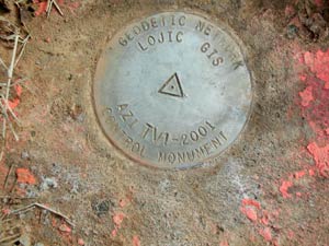
The Jefferson County, Kentucky, geodetic control network is a valued public resource, especially for the local professional land surveying and civil engineering community. Newly established by the Louisville/Jefferson County Information Consortium (LOJIC) GIS, this network consists of an extensive local grid of geodetic surveying markers, or "control monuments." A New Local Geodetic Control NetworkThere are numerous historical horizontal and vertical control systems in the County from various federal, state, local, and private sources--some of which are highly reliable--however, nearly all are spatially sporadic and vary in data, accuracy, and currency. A new network of accurate and routinely maintained geodetic control throughout the County was needed as a resource to
An approximate two-mile grid of geodetic control across Jefferson County (less in the urban core of Louisville) tied to the National Geodetic Survey (NGS) High Accuracy Reference Network (HARN) was sufficient to meet these needs. To minimize the installation of new monuments, existing control records were researched and field reconnaissance was performed to identify existing control monuments that were of suitable location, quality, and condition to be incorporated in the new geodetic network. In the summer of 2001, LOJIC contracted GRW Aerial Surveys, Inc. (Lexington, Kentucky) to recover existing survey control monuments, install numerous new monuments, and survey the existing and newly installed monuments using GPS survey techniques. LOJIC also contracted Fowler Surveys, Inc. (Elizabethtown, Kentucky), to monitor field activities and perform independent technical quality assurance throughout the project. New control monuments were installed in intervisible pairs consisting of a primary monument and an azimuth monument, each with an accurate coordinate position and elevation. LOJIC's Geodetic Control MapTo facilitate and enhance this effort, LOJIC developed an ArcIMS application to provide public access to the control data via the Web. This application, LOJIC's Geodetic Control Map, is the latest in a number of interactive maps that are accessible through the LOJIC GIS Web site. The Geodetic Control Map uses local digital orthophoto imagery in MrSID format as its basemap along with street names and control monuments, which are maintained in an Oracle/ArcSDE geodatabase.
Users can navigate and zoom in to an area of interest by entering a property parcel number, site address, street intersection, or the name of a specific control monument. One or more monuments may be selected in the map view by dragging a box or specifying a selection radius and clicking a center point on the map. Individual monuments may then be selected from a pick list. Control description sheets and reference photos for the selected monument can be displayed and printed by clicking on the appropriate icon. A simple preformatted site map may be created from the map view and users can display or download a County-wide geodetic control index map, the project survey report, and related project documentation. The Geodetic Control Map includes a detailed user guide, online help, and several links to a comment form that allow users to communicate suggestions and report on the condition of the control monuments via e-mail. New project databases accessible through the Geodetic Control Map include a control point geodatabase, control descriptions, digital photos of each monument, and north, south, east, and west lines-of-sight. GIS ResourcesLOJIC is no stranger to publishing interactive maps on the Internet, having already used Esri's ArcView IMS software. The Geodetic Control Map is LOJIC's first application to utilize the more robust ArcIMS software and an Oracle/ArcSDE geodatabase. While the majority of the Geodetic Control Map was assembled using the out-of-the-box capabilities of ArcIMS, the look, feel, and functionality of the final application was customized using HTML, JavaScript, and XML. Esri's Geography Network was a source of many ideas on format, presentation, and functionality. For more information on LOJIC GIS and the interactive Geodetic Control Map, visit www.lojic.org or contact Alex Talbott, Jr., LOJIC (e-mail: talbott@lojic.org, tel.: 502-540-6324) or Curt Bynum, LOJIC (e-mail: bynum@lojic.org, tel.: 502-540-6121). |